Home > Travel > States of India > Mawphlang
Mawphlang
Mawphlang is a place of tourist attraction in the state of Meghalaya because of its sacred groves.

Share this Article:

Mawphlang, MeghalayaLocated about 25 km from Shillong, the quaint village of Mawphlang is in the East Khasi Hills district of the state of Meghalaya.

Etymology of Mawphlang
Derived from the Khasi word, "maw" meaning stone and together with "phlang", the word Mawphlang means grassy stone

History of Mawphlang
During the 1890s, Mawphlang used to be a centre of Presbyterian Church of Wales missionary and medical activity in the Khasi Hills. A dispensary and then a clinic were established in 1878 by Dr Griffith Griffiths of Brynmawr, who died at Mawphlang. Once a princely state under the British Empire, Mawphlang came under the dominion of India after the country"s independence on 15th August, 1947.

Tourism in Mawphlang
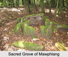
The village of Mawphlang is one of the famous sites for one of Khasi Hills" sacred groves. These sacred groves are closely linked to the indigenous culture and religious beliefs of the natives of the region. The most sacred among these is the Mawphlang Sacred Forest, which spreads over an area of about 192 acres.

Preserved for over a thousand years by the local Khasi tribes, the forest is believed to be the abode of the local deity, called "Labasa". According to the local tribal community, it is believed that Labasa in the form of leopard or tiger protects the forest and their community from any mishap. To appease the local deity, the villagers make animal sacrifices in the stone temples located within the forest. These sacred groves in the village of Mawphlang attract tourists and facilitate tourism in the East Khasi Hills district.

Visiting Information on Mawphlang
The nearest railway station is at Guwahati at a distance of almost 117 km and the Shillong Airport is the closest at a distance of about 52 km from the village of Mawphlang.

This article is a stub. You can enrich by adding more information to it. Send your Write Up to [email protected].


Share this Article:

Related Articles

More Articles in States of India


East Indian States
East Indian States comprises of Bihar, Jharkhand, West Bengal, Odisha and also the Union Territory of Andaman and Nicobar Islands. It defines the cultural heritage, rich historical background and the linguistic unity.
Erode District
Erode District is one of the districts in the state of Tamil Nadu. The district of Erode is having a land-locked area with no sea coast.
Purnia District in Bihar
Purnia District is located in Bihar and extends from River Ganga to Nepal. The district has a rich Hindu history and glorious past.
South Delhi District
South Delhi District is the third largest district of Delhi as far as its area is concerned. South Delhi District is known for its economic, historical, cultural and social significance.
North Indian States
North Indian States formed the cultural and religious unity in spite of having many foreign invasion and the political disturbances from the early era till the British gained supremacy in Indian sub continent.
Kendujhar District
Kendujhar District, spread over an area of 8,240 sq kms, is as varied as the whole of Orissa with waterfalls roaring gorges, mountains and minerals. The manifold expressions of nature in Kendujhar District are considered as unique.
Hooghly district
Hooghly District along the bank of the river Hooghly is one of the principal trading ports of West Bengal.
Districts of South Tamil Nadu
Districts of South Tamil Nadu consist of many tourism destinations like archaeological sites and the history of Pandyas and Cholas. Considering their proximity to the sea, many districts also boast of serene beaches and coastal beauty.
Flora of Arunachal Pradesh
Flora of Arunachal Pradesh includes infinite species and is a subject of great interests for the botanists.
Districts of South Gujarat
Districts of South Gujarat are the epicenter of Jain pilgrimages and the early Hindu kingdoms.
North West States of India
North West States of India consist of three states, which are Rajasthan, Punjab and Haryana. All of them are culturally and traditionally diverse and they have been ruled by different dynasties in historical time.
Geography Of Chittoor District
Geography of Chittoor district is spread along the topography of the land which is divided into two natural divisions; Chittoor has a dry and healthy climate.
Districts of North Rajasthan
District of Northern part of Rajasthan is dotted with ancient forts and medieval villages.
Districts of North Odisha
District of North Odisha has Bengal boundary and shares the same culture. These are reachable if one pays a weekend visit to Digha.
Districts of West Bihar
Districts of West Bihar is comprised of medieval monuments that were built by the different governors of Mughal era.
Districts of South Haryana
Districts of South Haryana consists of many cities of industrial excellence. These districts are dotted with popular tourism destinations.
Medieval History of Assam
Medieval history of Assam narrates the advent and rule of a number of kingdoms in the region. The prominent dynasties of the kingdom left an everlasting imprint on the socio cultural heritage of India.
Geography of Meghalaya
The suitable climate, highland plateaus, rivers and the flora and fauna together forms the geography of Meghalaya.
Districts of Rayalaseema
Districts of Rayalaseema in Andhra Pradesh state has urban population and rural settlements as well.
Districts of South Punjab
Districts of Southern part of Punjab depict medieval history of Punjab and the rise of Sikhs.