Introduction
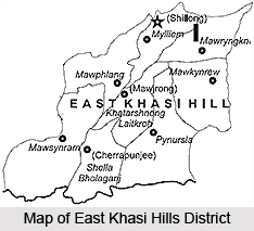 East Khasi Hills District is one of the seven districts of Meghalaya with its administrative headquarters located at Shillong. The district occupies an area of 2748 sq km. Khasi Hills District was divided into two districts namely East Khasi Hills District and West Khasi Hills District on 28th of October, 1976. On June 4th, 1992, East Khasi Hills District was further divided into two administrative districts of East Khasi Hills District and Ri-Bhoi District. The district consists of eight Community and Rural Development blocks at present. According to 2001 Census, total population of East Khasi Hills District is 2,306,069.
Location of East Khasi Hills District
East Khasi Hills District forms a central part of Meghalaya and East Khasi Hills District lies between 25 degree 7 minutes and 25 degree 41 minutes north latitude and 91 degree 21 minutes and 92 degree 9 minutes east longitude. This district of Meghalaya is bounded by Ri-Bhoi District in the north, Karbi Anglong District in the north east, Jaintia Hills District in the east, Bangladesh in the south and West Khasi Hills District in the west.
Geography of East Khasi Hills District
Geography of East Khasi Hills District is mostly hilly with deep gorges and ravines on the southern portion. The most important physiographic features of the district is Shillong Plateau interspersed with river valley, falling sharply in the southern portion forming deep gorges and ravine in Mawsynram and Shella-Bholaganj bordering Bangladesh. Shillong peak lying 10 kms from the city, offer a panoramic view of the scenic landscape and it is also the highest point in the district.
 Climate of East Khasi Hills District ranges from temperate in the plateau region to warmer tropical and sub-tropical pockets on the northern and southern regions. The district is influenced by the south-west monsoon which begins generally from May and continues till September. The weather is humid for the major portion of the year except for the relatively dry spell usually between December and March.
Culture of East Khasi Hills District
 Culture of East Khasi Hills District is basically tribal in nature. This district of Meghalaya is mainly inhabited by Khasi tribe. Khasis residing in Jaintia hills are now better known as Jaintias. They are also called Pnars. Khasis occupying the northern lowlands and foothills are generally called Bhois. Those who live in the southern tracts are termed Wars. Again among the Wars, those living in the Khasi Hills are called War-Khasis and those in the Jaintia Hills, War-Pnars or War-Jaintias. In the Jaintia Hills we have Khyrwangs, Labangs, Nangphylluts, Nangtungs in the north-eastern part and in the east. In the Khasi Hills the Lyngngams live in the north-western part.
Culture of East Khasi Hills District is basically reflected by the traditions, religious beliefs and ways of living of the tribal communities. Traditional Khasi male dress is `Jymphong` or a long sleeveless coat without collar. Khasi traditional female dress is rather elaborate with several pieces of cloth. On ceremonial occasions, they wear a crown of silver or gold on the head. Like the other tribes in the north-eastern region of India, among the Khasis also use of rice-beer is a must for every ceremonial and religious occasion. They have a matrilineal society.
 Khasis follow a matrilineal system of inheritance. In the Khasi society, it is only the youngest daughter or `Ka Khadduh` of a family who is eligible to inherit the ancestral property. Among the War-Khasis, however property passes to the children, male or female, in equal shares but among the War-Jaintias, only the female children get the inheritance. Marriage within a clan is a taboo. Rings or betel-nut bags are exchanged between the bride and the bridegroom to complete the union.
Music, crafts and costumes form an integral part of the culture of East Khasi Hills District. Khasis and Jaintias are particularly fond of songs praising the nature like lakes, waterfalls, hills, etc. and also expressing love for their land. They use different types of musical instruments like drums and instruments similar to guitars, flutes and pipes. Weaving is an ancient craft of the tribals of this region - be it weaving of cane or cloth. The Khasis are famous for weaving cane mat, stools and baskets. The Khasis have also been involved in extracting iron ore and then manufacture domestic knives, utensils and other warfare weapons using it.
Culture of East Khasi Hills District is also characterized by different festivals and their celebrations. `Nongkrem Dance` is a religious festival celebrated by the Khasis as a gesture of thanksgiving to Almighty God for good harvest, peace and prosperity of the community. It is held annually during October or November. Another most important festival of the Khasis is `Ka Shad Suk Mynsiem` or Dance of the joyful heart. It is an annual thanksgiving dance held in Shillong in April. This festival lasts for three days. Thus, it can be said that the culture of East Khasi Hills District is quite unique and vibrant.
People of East Khasi Hills District
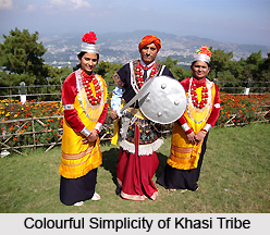
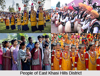 People of East Khasi Hills District constitute of the Khasi, Jaintia , Bhoi tribes who are collectively known as the Hynniewtrep people and they predominantly inhabit the district of East Khasi Hills, also known to be one of the earliest ethnic groups of settlers in the Indian sub-continent, belonging to the Proto Austroloid Monkhamer race. Khasis occupying the northern lowlands and foothills are generally called Bhois and those who live in the southern tracts are termed Wars. The common language spoken is the Khasi language and owing to the demands of globalization English as a colonial tongue is also being used by the educated masses as well as for official communications.
Costumes of East Khasi Hills District : The traditional Khasi male dress is `Jymphong` or a longish sleeveless coat without collar; fastened by thongs in front though as per the demands of time the Khasis have adopted the western dress. On ceremonial occasions, they appear in `Jymphong` and dhoti with an ornamental waist-band. Khasi traditional female dress is rather elaborate with several pieces of cloth, giving the body a cylindrical shape. On ceremonial occasions, they wear a crown of silver or gold on the head. A spike or peak is fixed to the back of the crown, corresponding to the feathers worn by the men folk. The Khasi lady wears a dress called `Jainsem` which flows loose to the ankles. The upper part of her body is clad in a blouse. Over these, she ties both ends of a chequered cotton cloth on one shoulder, thus improvising on apron. On formal occasions, worn over the `Jympien` is a long piece of Assam Muga silk called `Ka Jainsem Dhara` which hangs loose below the knees after being knotted or pinned at the shoulders. The `Tapmohkhlieh` or head-shawl is either worn by knotting both ends behind the neck or is arranged in a stylish manner as done with a shawl. The jewellery of the Khasis and the Jaintias are also alike and the pendant is called `Kynjri Ksiar`, being made of 24 carat gold. The Khasis and the Jaintias also wear a string of thick red coral beads round their neck called `Paila during festive occasions.
Foods in East Khasi Hills District : The staple food of Khasis is rice and they also into non vegetarian food. Like the other tribes in the North-East, the Khasis also ferment rice-beer, and make spirit out of rice or millets by distillation. Use of rice-beer is a must for every ceremonial and religious occasion.
Marriage System in East Khasi Hills District : The Khasis have a matrilineal society. Descent is traced through the mother, but the father plays an important role in the material and mental life of the family.
In the Khasi society, the woman looks after home and hearth, the man finds the means to support the family, and the maternal uncle settles all social and religious matters.
Khasis follow a matrilineal system of inheritance. In the Khasi society, it is only the youngest daughter or `Ka Khadduh` who is eligible to inherit the ancestral property.
If `Ka Khadduh` dies without any daughter surviving her, her next elder sister inherits the ancestral property, and after her, the youngest daughter of that sister. Failing all daughters and their female issues, the property goes back to the mother`s sister, mother`s sister`s daughter and so on. The Ka Haddon`s property is actually the ancestral property and so if she wants to dispose it off, she must obtain consent and approval of the uncles and brothers. Among the War-Khasis, however property passes to the children, male or female, in equal shares.
When it comes to marriage, the nuptial knot within a clan is a taboo. Rings or betel-nut bags are exchanged between the bride and the bridegroom to complete the union. In the Christian families, however, marriage is purely a civil contract. The Khasis are now mostly Christians. But before that, they believed in a Supreme Being, The Creator - U Blei Nongthaw and under Him, there were several deities of water and of mountains and also of other natural objects. The three major tribes of Meghalaya have distinct costumes and jewellery. However, with the change of time as in the rest of the country, the males have adopted the western code of dress leaving the ladies to continue the tradition of ethnic sartorial elegance.
Education in East Khasi Hills District : The history of formal education in Meghalaya in general and in East Khasi Hills District in particular has been a recent one commencing with the formulation of a Khasi Alphabet in 1842 by Mr. Thomas Jones, a Welsh missionary.
The first college was established in Shillong only in 1924 by the Christian Brothers of Ireland. Being a hill station blessed with bracing weather and having a strong colonial influence, several quality colleges and Public schools have been established over the years. Also several National Institutes of repute like the North Eastern Hill University which is a Central University, The North Eastern Indira Gandhi Regional Institute of Health & Medical Science (NEIGRIMS), the Indian Institute of Management (IIM), National Institute of Fashion Design (NIFT), Indian Institute of Hotel Management, Central Institute of English & Foreign Languages(CIEFL) and various other Prominent Institutes of Higher Learning have since then been set up at Shillong, the district headquarter.
Festivals of East Khasi Hills District
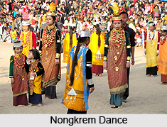
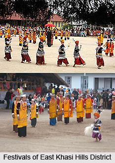 Festivals of East Khasi Hills District include those of Nongkrem Dance etc. Nongkrem Dance is a sacred festival that in the truest sense has its roots in the thanksgiving ritual to God Almighty for good harvest, peace and prosperity of the community. It is held annually during October/ November, at Smit, the capital of the Khyrim Syiemship near Shillong. As autumn drops by the hills, this magnanimous occasion witnesses its advent, its verve. The mountain comes to life, so do the tribe as the mood of tribal festivity pours in. On the fourth day of the Khasi dance, all the young girls together perform this dance in a ring in front of the priestess`s house. The dance depicts the warlike movements of the young folks who dance in a circle forming a ring in which the girls sway their heads slowly. This dance is considered as one the greatest dance festivals of the Khasis.
The dance is performed in the open by young virgins and men, both bachelors and married. The women dressed in expensive silk costumes with heavy gold, silver and coral ornaments dance in the inner circle of the arena. The men form an outer circle and dance to the accompaniment of music of flutes and drums. An important feature of the festival is the `Pomblang` or goat sacrifice offered by the subjects to the Syiem of Khyrim, the administrative head of the Hima (Khasi State). Ka Syiem Sad, the eldest sister of the king is the chief priest and caretaker of all ceremonies. The festival is conducted along with the Myntries (Ministers), priests and high priest where offerings are made to ancestors of the ruling clan and the deity of Shillong Shad Suk Mynsiem.
Nongkrem Dance Festival is usually arranged in a particular place called Smit which is the cultural centre of the Khasi hills in Meghalaya. This is located at a distance of 11 kms from Shillong. The festival was originally named after Ka Pemblang Nongrem which later on came to be known as Nongkrem dance Festival. This ceremony is usually performed by the Syiem of Khyrim along with the eldest priest of the community. It includes sacrifice of animals like a cock which is offered as an obligation to Lei Shillong; the God of Shillong peak. The offer is made to the ancestors of the ruling clan.
Besides the religious practice, the festival is equally entertaining owing to the cultural programmes which are organised during the festival. Often the young and unmarried boys and girls participate in it. The dances performed by the young people ooze with energy and grace. They usually dance with a sword which they carry in their right hand and a bunch of white hair of the Yak in their left hand while keeping pace with the changing tunes of the drums and pipes. One of the most important festivals of the Khasis is Ka Shad Suk Mynsiem or Dance of the joyful heart. It is an annual thanksgiving dance held in Shillong in April. Men and women, dressed in traditional fineries dance to the accompaniment of drums and the flute. The festival lasts for three days. With the advent of Christianity and the embracement of the Christian faith by the Khasis, various Christian festivals like Christmas, Good Friday, and Easter etc are celebrated during the year.
Tourism in East Khasi Hills District
 Tourism in East Khasi Hills District comprises visits to several amazing sites including parks, waterfalls, museums, lakes and more. Visiting East Khasi Hills District will give the travellers a peaceful and memorable experience. There is no dearth of tourist attractions in East Khasi Hills District. The scenic beauty of the nature adds charm to the travelling experience of the tourists.
Some of the popular attractions of East Khasi Hills District are as follows -
Shillong Peak: An ideal picnic spot, 1965 metres above sea level and 10 kms from the city, offers a panoramic view of this country side. It is also the highest point in Meghalaya.
Sohpetbneng Peak: This peak is 1343 metres above the sea level, 20 kms from Shillong, and is regarded as sacred by the local people. It provides a beautiful scenic view against the backdrop of a sacred forest. This `Navel of Heaven` as per Khasi mythology is considered as a heavenly peak.
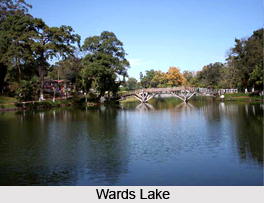
Ward`s Lake: Ward`s Lake is century old picturesque lake also known as Polok Lake. Located in the heart of the city, it is popular for boating. The lake has a striking arched bridge over it.
Umiam Water Sports Complex: The Water Sports Complex has been developed upon the mighty reservoir of the Umiam Hydro Electric Project, at Umiam Lake, 16 kilometres before reaching Shillong. The campus offers a wide choice of exciting water sports activities with row-boats, paddle-boats, cruise-boats, sailing-boats, water-scooters, speed-boats and a floating restaurant with ferry services.
Botanical Garden: A secluded but captivating spot with a plethora of indigenous and exotic plants and is located just below the Ward`s Lake. It also houses a mini-aviary with rare and colourful species of birds. The secluded setting of the Botanical Garden with its well-laid paved walks makes it a favourite resort for city dwellers as well as the tourists.
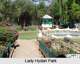
Lady Hydari Park: Lady Hydari Park, stretching over a km is replete with roses and blossoms of exquisite hues and colours, is a feast to eyes. It has an excellent mini zoo cum deer park.
 State Museum: State Museum is located in the state central library premises with a good collection of artifacts of North Eastern India.
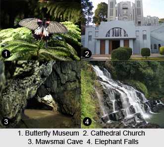
Elephant Falls: 12 kms on the outskirts of the city the mountain stream descends through two successive falls set in dells of fern-covered rocks.
Crinoline Falls: Located in the heart of the city adjacent to the Lady Hydari Park, lies the Crinoline Falls which cascades through its jungle path.
Diengiei Peak: Located to the west of the Shillong plateau, Diengiei Peak presents a spectacular view of green mountainous hills. The captivating hills are dotted with tiny shining villages.
Dwarksuid: An enigmatically beautiful pool with wide, rocky sand banks located on a stream alongside the Umroi-Bhoilymbong Road is known as Dwarksuid or Devil`s doorway. Its lotus-like rock formations are captivatingly scenic and magnificent.
Cherrapunji: Better known as Sohra, Cherrapunji is one of the most visited tourist spots of North Eastern India. Situated 56 kms from Shillong and 1300 metres above sea level, Cherrapunji is known popularly known as the rainiest place on the planet. The town is also famous for its limestone caves, oranges and as a Centre of the Khasi Culture and literature. The oldest Theological College in this region is located here. In addition, the natural beauty is complemented by springs and sacred forests.
Moreover, there are several caves in Khasi Hills like Krem Mawmluh and Krem Phyllut that attract the tourists from all parts of the country.
How to Reach East Khasi Hills District
The headquarters of the district Shillong is connected to Guwahati and Silchar by National Highway 44. The nearest Rail head and airport are at Guwahati. Further, Shillong is well connected with other parts of the state. Similarly, all the block headquarters in the district are also connected by roads.