
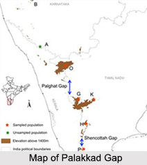
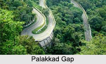
 Also known as the Palghat Gap, the Palakkad Gap is an east west trending low mountain pass across the Western Ghats between the cities of Coimbatore and Palakkad in the Indian states of Tamil Nadu and Kerala respectively. The Palakkad Gap is a low level landform standing at a height of about 140 m with a width of 24 to 30 km. The Nilgiri Hills to the north and the Anaimalai Hills to the south of this gap are marked by remnant plateau landforms.
Origin of Palakkad Gap
With various theories and speculations out there regarding the origin of the Palakkad Gap, the concrete theory is that it is caused by the landslide due to rivers flowing in opposite directions. The second longest river of Kerala, the Bharatha Puzha River originates here in the Palakkad Gap from rivulets and tributaries feeding from steep escarpment slopes along the flanks of the Western Ghats.
History of Palakkad Gap
Having played a major role in enabling the migration of people from parts of Tamil Nadu to Kerala, the Palakkad Gap from the 15th to 18th century helped in the migration of Tamil Brahmins to Palakkad from central Tamil Nadu. During the rule of the Cheras from 300 BC to 13th century, the Palakkad Gap helped them to rule over entire Kerala and the Kongu Nadu as one geographical unit from Karur in western Tamil Nadu.
 Palakkad Gap"s effect on Weather
The Palakkad Gap allows the moisture laden southwest monsoon winds into Tamil Nadu thus affecting the weather patterns of the south Indian states. This results in moderate summer temperatures and generates huge amounts of rainfall in the region which is relative to the rest of lowland of Tamil Nadu. The Palakkad Gap also allows hot winds from Tamil Nadu which warms the eastern part of Kerala and the tropical cyclone winds from Bay of Bengal bearing rain during the summer.
The Coimbatore and Tripura districts around the Palakkad Gap is one of the major wind power generation areas as the gap funnels the west blowing winds on to these regions. With large windmills around the areas of Udumalaipettai and Kadathur, the average annual wind speed is 18 to 22 km per hour.
Trade via Palakkad Gap
The Palakkad Gap acts as an important transport corridor between the states of Kerala and Tamil Nadu and earlier has served as a vital trade route between the east and west coasts of peninsular India. Both the National Highway 544 and the Coimbatore - Shoranur railway line joining Kerala to Tamil Nadu pass through the Palakkad Gap.









