Home > Indian History > Geography of India > Nigeen Lake
Nigeen Lake
Nigeen Lake is a eutrophic lake in Srinagar District of Jammu and Kashmir.

Share this Article:

Nigeen Lake, Srinagar District, Jammu and KashmirNigeen Lake is a mildly eutrophic lake located in Srinagar of Srinagar District in Jammu and Kashmir. Nigeen Lake is connected with both roadways and airways, as it is located in the midst of the capital city of Srinagar in Srinagar District of Jammu and Kashmir.

Location of Nigeen Lake
Nigeen Lake is located adjacent to the Hari Parbat hillock, to the west of the Dal lake. To its north and west, lie the localities of Baghwanpora and Lal Bazar while to its north east lies the locality of Hazratbal, which is known for the famous shrine.

Geography of Nigeen Lake
Nigeen Lake is sometimes considered a part of the Dal Lake and is connected to it via a narrow strait. It is also connected to the Khushal Sar and Gil Sar lakes via a channel known as Nallah Amir Khan.

Extension of Nigeen Lake
Nigeen Lake is surrounded by a large number of willow and poplar trees. Hence, it has came to be referred as a "nageena", which means "the jewel in the ring". The word "nigeen" is a local variant of the same word.

Tourism in Nigeen Lake
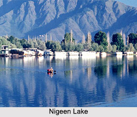
Nigeen Lake is a major tourist attraction in Srinagar, known for its relatively pristine waters as compared to the Dal Lake. Houseboats and shikaras are a usual sight. It is also ideal for swimming, being deeper and less crowded than the Dal lake. Nigeen Lake is the tourist"s paradise. However, as is the problem with other water bodies in the Kashmir Valley, the lake also suffers from encroachments which are deteriorating its water quality and also increasing the risk of floods. As such, the government of Jammu and Kashmir is engaged in taking steps to help improve the condition of the lake and restore it to its original glory.

This article is a stub. You can enrich by adding more information to it. Send your Write Up tocontent@indianetzone.com

Related Articles
Water Resources in India
Indian Rivers
Lakes of India
Sonamarg, City in Jammu and Kashmir
Jammu and Kashmir
Culture of Jammu and Kashmir
Costumes of Jammu and Kashmir
Srinagar,Jammu & Kashmir
Tourism In Srinagar, Jammu And Kashmir


Share this Article:

Related Articles

More Articles in Geography of India


Geography of Uttar Pradesh
The fourth largest State in India UP is located in the Northern part of India whose area is 2,36,286 sq Kms.
Geography of Maharashtra
Covering an area of 308,000 sq. km, Maharashtra, the third largest state in India.
Geography of Kerala
Geography of Kerala includes plains, hills, valleys and coasts. With the Arabian Sea in the west, the Western Ghats in the east and networked by several rivers, Kerala enjoys diverse geographical features.
Geography of West Bengal
The geography of West Bengal is unique with high peaks of the Himalayan range in the north, the Bay of Bengal in the south and the remaining region is covered with both plains and plateaus.
Geography of Jharkhand
Geography of Jharkhand is comprised of the rich mineral resources and the highly agricultural prospect in this state.
Geography of Sikkim
Geography of Sikkim is characterised by a vast array of magnificent hillock that extends from one corner of the state to the other.
Geography of Meghalaya
The suitable climate, highland plateaus, rivers and the flora and fauna together forms the geography of Meghalaya.
Geography of Mizoram
Mizoram is surrounded by hills, valleys, rivers, waterfalls and lakes. The hills range from 1000 meters to 2000 meters. Rivers, lakes and waterfalls also play major role in forming the land of Mizoram.
Geography of Jammu & Kashmir
Jammu and Kashmir is encompassed by valleys. Some of the dominant valleys of the state are Kashmir Valley, Tawi Valley, Chenab Valley, Poonch Valley, Sind Valley and Lidder Valley etc. Jhelum River is the only major Himalayan River which flows through the Kashmir valley. Indus, Tawi, Ravi and Chenab Rivers are the major ones flowing through the region.
Geography of Daman and Diu
Daman and Diu is situated on the west coast of India and are the smallest union territories of India.
Geography of Goa
Geography of Goa occupies a prime location along the Konkan coastal belt on the western coast of India. The state is bordered by Maharashtra in the north and Karnataka in the south. The Western Ghats in the east contribute to the flora and fauna of Goa.
Geography of Arunachal Pradesh
Geography of Arunachal Pradesh reveals that it is a hilly tract nestled in the foot of Himalayas.
Geography of Kutch
Geography of Kutch District is covering an area of 45,612 km. Kutch District is the largest district in the state of Gujarat.
Geography of Ladakh
Geography of Ladakh mainly comprises the huge Karakoram Range with long stretch of cold desert which mark the region separately from the rest of the states of Indian subcontinent. Surrounded with the mountain ranges from all corners this small region separates Indian subcontinent from rest of the Asian continent.
Geography of Rajasthan
Geography of Rajasthan defines the dry topography with arid climate of the western mountain region.
Geography of Tamil Nadu
The Indian state of Tamil Nadu is located in the Northern hemisphere in the hot zone.