 Territorial Integrity is the primary criterion which is taken up as a governing factor in maritime Indian interests. With piracy, militancy and terrorism raking the country`s borders, Indian military forces are always up in arms to safeguard the country`s emergency interests.
Geo-Economic Interests
UNCLOS III (United Nations Convention on the Law of the Sea) grants coastal states with sweeping powers within the Exclusive Economic Zone (EEZ), including rights for the purpose of exploring and exploiting, conserving and managing the ocean resources, living or non living. UNCLOS III bestows upon India almost 3.1 million sq. km. of EEZ after taking into account the continental shelf. Protection of the living and non-living resources in this vast EEZ is in India`s vital maritime interest.
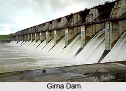
Oil and Natural Gas: It has been estimated that the continental shelf around India up to a depth of 200 metres can have an approximate potential oil reserve of 1 billion tonnes and natural gas reserve of around 271 billion cubic meters. Under India`s maritime interests, the stupendous discovery of Bombay High has been the biggest oil find in the country and it rates as one of the six biggest fields in the world. After Bombay High, surveys have led to the discovery of many satellite fields, like Panna, Bassein, Heera, Tapti, Mukta, and Leela. The discovery of major oil fields off the Andhra Coast, Cauvery Delta and in other areas of Bay of Bengal, further protection and security have been accounted for as a key governing factor in maritime strategy.
Deep sea mining: India`s contribution in deep sea mining has been recognised with the status of a `pioneer investor`. The country has been given the right of deep-sea bed mining in the equatorial Indian Ocean, an area of 1.5 lakh sq. km about 2500 km south of India. In order to evenly exploit Indian maritime interests, the country have started to tap resourceful areas underwater in search for more options. Ocean bed mining activity at present is limited to exploration, research and development, but not exploitation. The National Institute of Oceanography, India`s only oceanographic institute, is, however, conducting extensive research in this field.
Fishing: Indian maritime interests very much is rested in fishing, both deep sea and shallow. The seas are an excellent source of nutrition. India is auspicious to have an abundance of fish in its waters. India is looking towards a yet unrealised achievement of 3.92 million tonnes, including 2.28 million tonnes (58 percent) from the coastal waters and 1.64 million tonnes (42 percent) from offshore. Protection of this vast resource is considered cardinal.
Port Infrastructure: Another factor, which affects the trade potential of India, is its port infrastructure. There are 12 major ports and 185 minor ports in India. The World Bank has approximated that India`s present port handling capabilities could be boosted by around thirty to thirty-five, by a thorough overhauling of existing port management practices. Indian ports handle seven to eight containers in an hour, making port infrastructure a vital governing factor counted under Indian maritime strategies. Advancement has been made with the development of ports such as Paradip, Mangalore and Ennore. Headways have also been made in the mushrooming of private ports, especially in Gujarat.
 The Oceans as a Resource
The oceans of the world bring together nations as they provide the path for people and trade to move from one country to another. The Indian Ocean extends India`s neighbourhood to beyond the normally accepted concepts of land borders, to far away nations like South Africa and Australia. Maritime interests of India thus are often focussed on various outlandish subjects, involving such far-off countries.
Protection of SLOCs (Sea Lines of Communication): Ninety-seven percent of India`s international trade in terms of volume and seventy-five percent in terms of value are moved by sea. Most of India`s oil imports are from the Persian Gulf region. Indian maritime interests are quite logically, harnessed from this region.
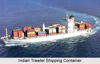
Shipping Industry: When India became independent in 1947, it had no shipping industry to speak of. Substantial progress has since been made. In 2000, Indian companies together possessed 514 ships with a capacity of 6.86 million GRT. With shipping becoming more and more a key governing factor under Indian maritime strategy, approximately thirty percent of Indian sea borne trade is carried in Indian freighters.
Non-Conventional Energy: The oceans afford India the opportunity to expand energy through non-conventional means such as tides and waves. The Gulfs of Kachchh and Cambay are ideal for production of electricity by harnessing the gigantic tidal variations. Maritime interests of India are thus being manoeuvred towards successful tapping of these hidden oceanic energies. India`s long coast line provides many suitable locations to harness the energy of the waves to produce electricity.
Regional Stability in the IOR (Indian Ocean Region) region is another fundamental governing factor under maritime strategies that India has started to utilise in order to safeguard its population interests.