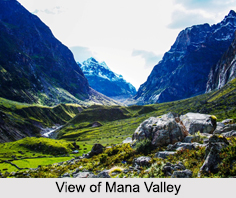
 Mana Valley with an altitude of 5545 meters is located in the Himalayan Mountain Ranges. This valley lies in the hinterland of Badrinath. Earlier this valley was used by the Rongpa traders for trade in Tibetan markets. Due to this trade, Mana Valley was an important one. It is one of the difficult passes in the region. The villages near this valley are Mana, Gajkoti, Pathya, Dhantoli, Ghunai, Pandu Kesar, Arudi - Patudi, Ghata and Pinaula.
Geography of Mana Valley
Mana Pass is located within the Nanda Devi Biosphere Reserve, 24 km north of the town of Mana and 52 km north of the Hindu pilgrimage town of Badrinath in Uttarakhand. It is the source of the Saraswati River.
Visiting Places near Mana Valley
There are several visiting places near Mana Valley and some of them are Ghantya Karan Mandir, Mata Murty Mandir, Bala Sundri Mandir, Bhimpul, Shanti Van, Vishnu Prayag Sangam, Ganesh Gufa, Byas Gufa, Basudhara, Badrinath Dham, Brahm Kapal, Shesh Netra, Kagbhusan, Hanuman Chatti etc.
Visiting Information to Mana Valley
Mana Valley can be reached via Badrinath; Indian National Highway 7 connects Fazilka with Badrinath. Nearest airport is Jolly Grant Airport on Rishikesh-Dehardun and nearest railway stations are Dehradun (341km) and Haridwar (324km). From Badrinath the last village near the valley is Mana, which 50 km by road.


