
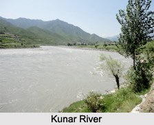
 The Kunar River system is located in northern Khyber Pakhtunkhwa in Pakistan and eastern Afghanistan. More specifically, it is located in the provinces of Khyber Pakhtunkhwa, Nuristan, Kunar and Nangarhar. The source and mouth of this river is located in different places. It originates from Hindu Kush Mountains while its mouth is Kabul River, located in Jalalabad. It is also an Indian river as it forms part of the Indus watershed basin.
Geography of Kunar River
Globally, Kunar River can be pinpointed at coordinates 34.4021 degrees North and 70.5367 degrees East. This river has a length of about 480 km (298 mi) and basin of about 2,600 km2 (1,004 sq mi). The melting glaciers and snow from the Hindu Kush Mountains form the water source of Kunar River.
Course of Kunar River
The Kunar River starts it"s journey in the north glaciated Hindu Kush Mountains of Chitral, Khyber Pakhtunkhwa, Pakistan. It is known as the Mastuj River, downstream from Mastuj to its confluence with the Lutkho River, which is located north of Chitral. Its name then changes to Chitral River, before flowing south into the upper Kunar Valley of Afghanistan. It then joins the Pech River, at the confluence in Asadabad (also known as Chaga Sarai). It then flows towards the Kabul River, just to the east of the city of Jalalabad in Afghanistan and amalgamates with it. The next destination of the two rivers combined together is Pakistan again which is reached flowing eastwards. It roughly follows the Grand Trunk Road through the Khyber Pass and meets the Indus River at the city of Attock.
Tributaries of Kunar River
Kunar River has tributaries on the left and right. Its left tributary is the Shishi River and right one"s are the Pech River, Lutkho River and Landai Sin River.
Trade Route of Kunar River
Before the political division of the area divided the Kunar and Chitral Valley between the modern nation states of Afghanistan and Pakistan, it had formed a significant trade route, being the easiest way to pass through from the Pamir Mountain"s passes to the plains of the Indian subcontinent.
Development of Kunar River
Development of Kunar River is ensured by the Golen Gol Power Project. This project has been undertaken to exploit the hydropower potential of this river for the generation of hydro electricity at low cost.
Related Articles:
Indian Rivers
Himalayan Rivers
Indus River
Coastal Rivers
Deccan Rivers









