
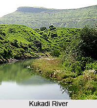
 Kukadi River flows across the city of Bori in the Indian state of Maharashtra. It is a tributary of the Ghod River. Several notable temples lie on its banks including the Vigneshwara Temple and Malganga Devi Temple. The Yedgaon Dam is on this river, creating an artificial lake. During the months when it is visible, the riverbed is considered to be a wonder of nature, characterized by rock erosion from water movement and gorges that are gouged with large potholes. Folk tales abound about the river. The river valley is characterized by grape vineyards.
Course of Kukadi River
The Kukadi, originating in the Western Ghats, is an easterly flowing tributary of the Ghod. The source of the river lies in the Western Ghats near Naneghat. The river passes to the north of Junnar and is situated outside Nighoj, near a road to Shirur.
The Kukadi`s tributaries include the Dimbhe, Manikdoh, Pimpalgaon Joge, Wadaj, and Yedgaon. The river rises in the Western Ghat`s high rainfall zone where the annual rainfall is greater than 4,000 mm.
 Kukadi Irrigation Project
The Kukadi Irrigation Project is a program in progress by the Maharashtra Krishna Valley Development Corporation. Approved in 1968, it is almost complete, with the remaining work on some of the distributory systems still in process. It includes five storage dams across the five tributaries; viz. Yedgaon Dam, Manikdoh Dam, Dimbhe Dam, Wadaj Dam and Pimpalgaon Joge Dam.
Potholes on the Kukadi Riverbed
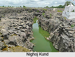
Nighoj is a village in Ahmednagar district of Maharashtra. It is famous for the naturally created potholes on the riverbed of the Kukadi River which is also called as "Nighoj Kund" as per the villagers. Experts from all over the world come here every year to study the phenomenon of their formation. It is Asia"s largest natural gigantic potholes recorded in the Guinness Book of World Records.
Geologists indicate that formerly there was high rainfall in this area. Over the years, in this geographical phenomenon where the pebbles are carried by the river get locked in the cracks developed in the basalt rock riverbed. These small hard pebbles vigorously swirl in these wear out areas due to flow of the water to create circular pot hole shaped cavities in the basalt rock over the hundreds of years. The interiors of potholes are smooth and regular. The Gorge is just about 2-3 kms in length and is hardly visible from a distance. Over the years the depth of these potholes has increased and villagers tell that they could be even more than 100 ft deep at few spots.









