
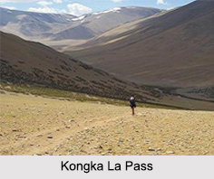
 Kongka Pass with an elevation of 5171 meters is a high mountain pass of the Chang-Chemno Range on the Line of Actual Control. Kongka Pass, also known as Kongka La Pass of Himalayan Mountain Ranges is situated on the India-China border near Ladakh. The location of the pass is quite debatable because China considers the Kongka Pass as its boundary with India, whereas India regards Lanak Pass further east as the boundary with China. During British era, Lanak La was decided to be the border between Ladakh and Tibet but modern scholars consider Kongka Pass as the traditional border between the two countries. This pass is mostly popular for the Indo-Sino war of 1962 between India and China.
Kongka Pass A UFO Base
Several incidents have happened in and around Kongka Pass which clearly prove Kongka Pass as a UFO base. According to the locals and other government officials from the Indian Army, UFOs have been seen landing in and around the pass several times. People have noticed strange lights occurring at midnight. However, strong evidence to prove the occurrence of such unusual activities has still not been found.
Cause of Indo-Sino War on Kongka Pass
In October 1959, Indian army crossed the Kongka Pass in an attempt to establish posts on the Lanak Pass. This resulted in a clash with the Chinese army on Kongka Pass. Nine Indian soldiers were killed out of 70 and ten were imprisoned. This incident further preceded the Indo-Sino war of 1962.
Visiting Information to Kongka Pass
The best time to visit the pass is from June to end of September, when weather remains favorable. During winter time Kongka Pass experiences heavy snowfall, hence it becomes difficult to reach the location conveniently as several roads get blocked by the snow. Nearest airport of Kongka Pass is located at a distance of 200 km at Leh. Jammu Tawi Railway Station is the nearest railhead of the pass located at a distance of 425 km. To reach the pass by road, one can go up to Shyok, which is 70 km from the pass. From Shyok one has to walk till Kongka Pass.









