Introduction
 Hingoli district of Maharashtra is one of the newest districts in the state. It came into existence as a result of the division of Parbhani district on 1st May 1999. It consists of two sub divisions namely Hingoli and Basmath and five Talukas namely Hingoli, Basmath, Kalamnuri, Aundha Nagnath and Sengaon. Initially, the district served as a military base for the Nizams being close to the border of Vidharba. The district covers a total area of about 4,526 square kilometres, and has a population of roughly one million (as per the 2001 census reports). With an average rainfall of about 900 mm, the district is well known for the production of cotton and jowar crops. Bharud, Gondhal and Shahiri are folk arts typical to the region.
Location of Hingoli District
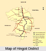
Hingoli district is situated in the northern part of Marathwada in the state of Maharashtra. It is bordered by Akola and Yavatmal district on the northern side, Parbhani in the western side and Nanded district in the south-eastern side. The district lies between the latitude and longitude of 19.43 north and 77.11 east respectively.
History of Hingoli District
Marathwada was initially under the rule of the Nizam, and a part of the Parbhani district. It served as the military base of the Nizam as it bordered Vidharba. Military troops, hospitals and even veterinary hospitals all functioned from Hingoli. Residents of Hingoli had experienced two big wars between Tipu Sultan and the Marathas in 1803 and in 1857 between Nagpurkar and Bhosale. Some of the names like Pultan, Risala, Tophkhana, Pensionpura, Sadar Bazaar are famous even today. When the state was reconstructed in 1956 post independence, Marathwada was attached to Mumbai state. In 1960, Hingoli became a part of the state of Maharshtra as part of the Parbhani district. Later, on the 1st of May, 1999, Hingoli district came in to existence by the division of Parbhani district.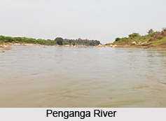
Geography of Hingoli District<
Hingoli district is situated in the Northern side of Marathwada. The tehsils of Sengaon, Hingoli, Kalmnuri and Aundha are scattered on this hilly tract. The mountain ranges run in an east-west direction. The average height height from mean sea level is 500 to 600 metres. The major rivers flowing through the district of Hingoli are the Penganga River, the Purna River and the Kayadhu River. The Kayadhu is the main river of the district. It flows through Sengaon, Hingoli, Aundha Nagnath and Kalamnuri. It meets the Penganga River in the Nanded district. The Penganga River flows through the northern region of the district passing through the Sengaon taluka and the Kalamnuri taluka. The Purna River flows from the southern side of Sengaon. It flows further south from Aundha and Basmat. The district is primarily agricultural. Among the major crops grown here, cotton, jowar, mango, pulses, rice, groundnut etc are the autumnal crops, whereas wheat, jowar, gram etc are the Rabi crops. There are three main dams that have been constructed in the district. These are the Upper Penganga dam built on the Penganga River, the Yeldari dam on the Purna River and the Siddeshwar dam which is also constructed on the Purna River.
Pilgrimage Tourism in Hingoli District
 Pilgrimage tourism in Hingoli district is an enriching experience. There are beautiful temples located in the district which are well worth a visit when on a visit here. One of the holiest sites for the Hindus, the site of the existence of the twelve Jyotirlingas is also found here. At Aundha Nagnath there is found what is said to be the eighth of the twelve Jyotirlingas. The beautifuk temple situated here is said to be very old, as it has been constructed by Dharmraj, one of the Pandavas, while they were in exile. Other places of pilgrimage tourism in Hingoli district include the Mallinath Digambar Jain Temple Tulaja Devi Sansthan and the Sant Namdev Sansthan. These are briefly discussed below.
Aundha Nagnath
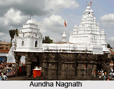
The twelve jyotirlingas are the most significant places of pilgrimage for Hindus in India. Five of them happen to be in the state of Maharashtra. Lord Shiva has been worshipped in these places for centuries. Aundha-Nagnath in the district of Hingoli is one of them. This pilgrim centre is of great significance, since it is considered to be the Eighth (adya), of the 12 jyotirlingas. It is believed that Dharmraj (eldest of the Pandavas of Mahabharat) had constructed this beautiful temple during the time that they were expelled for 14 years from Hastinapur. The temple has been constructed in the Hemadpanthi style of architecture and has exquisite carvings. It is situated in an area of about 60,000 sq. ft. A large number of pilgrims visit this temple on Shivaratri and Vijayadashami.
Mallinath Digambar Jain Temple
At Shirad Shahapur village of Aundha Nagnath taluka place lies a historical temple of the Jain community. There is found here a statue of Lord Mallinath which is about 300 years old. There is a legend behind the establishment of this temple. Years back the idol was placed at Ardhapur. Bhattarak shree Premanand once saw this idol placed in between other confuted idols and was annoyed. He sought permission from the Nizam to move the idol to Karanja. The Nizam permitted him to take the idol to Karanja. While he was travelling he once stayed at Shirad Shahapur. There he saw a dream in which he was given a message to establish the idol at Shirad Shahpur, and thus the famous temple came into existence. Now it is well constructed with facilities for pilgrims to stay. A number of Jain pilgrims from all over India visit this place.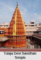
Tulaja Devi Sansthan
Around 125 years ago, swami Keshavraj had a divine vision of the Goddess Tulja Bhavani, and later on her found a sculpture of the Goddess while excavating a cave. He constructed the temple at the same place. In the year 1967, a trust was formed to run the temple. Now the trust is trying to provide scholarships to students, residential complex for pilgrims and health service.
Sant Namdev Sansthan
The village of Narsi situated in the district is the birthplace of the Saint Shree Namdev. Named as Namdev Damaji Relekar, the great saint was born in the year 1270. Every year a fair is arranged in the village in memory of the saint. The state government has declared Narsi as holy place and tourist place. The government has constructed a tourist home at Narsi. There are many followers of saint Namdev from Punjab and the rest of India who frequently visit Narsi. Now the Sikh followers are constructing a Gurudwara at Narsi and they have also decided to construct a memorial of saint Namdev.


