Introduction
 The East Godavari District is located towards the northern coast of Andhra Pradesh. This district is also known as the `rice bowl` of Andhra Pradesh because of its lush green paddy fields. The district headquarter of East Godavari is Kakinada. The district was formed in the year 1925 when the old Godavari district was divided into two parts namely the east and the west.
History of East Godavari
 The history of the East Godavari district has been created by a long period of dynastic rule. A number of different dynasties held sway over the region, and its earliest history can be traced back to the period of rule of the Nandas. Mahapadma Nanda, the founder of the Nanda dynasty led expeditions and defeated several monarchs of a large portion of the Deccan. Following the Nandas, the region came under the rule of a number of different dynasties. Following the Nandas, Chandragupta Maurya, the founder of the Maurya Empire assumed control over the empire which included a large portion of the Deccan. After the Mauryas, the district passed under the sway of the rulers of the Satavahana dynasty. The satavahanas appeared to have ruled till the first quarter of the third century A.D. Samudra Gupta, the Gupta ruler, who invaded this district in A.D.350, came into conflict with the rulers of both Pishtapura and Avamukta. The local rulers joined the rulers of neighbouring principalities to resist the onslaughts of the Gupta ruler. Samudra Gupta`s invasion was followed by the rule of a line of kings belonging to Matharakula. Their rule extended roughly from 375 A.D to 500 A.D.
The district passed into the hands of Vishnukundin during the rule of Vikramendravarma I. They ruled for over two centuries from the first quarter of the 5th Century A.D. or a little earlier. The records discovered indicate that their domain extended over Visakhapatnam, West Godavari district, Krishna district and Guntur district, besides the present East Godavari district. Ranadurjaya ruled Pistapuram or Pithapuram as a vassal of Vikramendravarma in recognition of his services to the state. Another Vishnukundin, ruler of lndrabhattaraka, defeated the rulers of Vasisthakula and re- established his authority over this region. Indrabhattaraka was followed to the throne by a few others belonging to the same family. Madhavarama III was the last important ruler of this family. Madhavarama III was, however, killed in a battle. He was succeeded by his son, Manchannabhattaraka who strove hard to maintain his hold over the ancestral dominion without much success.
Later, the western Chalukya ruler of Badami, Pulakesin II, with the help of his brother Kubjavishnu, attacked Pistapura and emerged victorious. Kubjavishnu was given the newly acquired territories in the east in token of appreciation of the service rendered by him. The rulers of eastern Chalukya dynasty founded by Kubjavishnu, ruled at first form Pistapura, then from Vengi and later from Rajamahendri (Rajahmundry). Many rulers held sway over the kingdom and their history is, at times largely a record of disputes about succession. Chalukya Bhima I, who ruled during A.D.892-921, built a temple in honor of Siva at Draksharama.
In 973 A.D. the eastern Chalukya ruler, Danarnava, was killed and Vengi was occupied by Jata Choda Bhima of Pedakallu in Kurnool district who ruled for 27 years. Vengi went on to become the bone of contention between the Cholas and Chalukyas of Kalyani to the West. Vijayaditya VII lost his and with his death in A.D 1075 the eastern Chalukya dynasty came to and end.
With the accession of Rajendra under the title of Kulottunga Chola I, an eastern Chalukyan prince and a rival of Vijayaditya VII, to the Chola throne, this district along with the rest of the Vengi kingdom became a province of the Chola Empire. These rulers were known as Chalukya-Cholas. A major portion of the district was also ruled by a local dynasty known as Velanati Cholas. The other rulers of this dynasty were Gonka I, Gonka II, Kulottunga Rajendra Chola I and Kulottunga Rajendra Chola-II (A.D. 1108-1181). The sudden demise of Kulottunga Rajendra Chola II in A.D.1181 led to the outbreak of civil war among the heirs of Kulottunga Rajendra Chola for the possession of the throne. With this, the rule of Velanati Chola over this district ended
An early ruler of Kakatiya dynasty, Prola II threw off the Imperial Yoke of the western Chalukyas of Kalyani and asserted his independence. During his reign, he was opposed by the Haihayas of Knoa. Prola II was succeeded by his son Rudra (A.D.1150-1195), who obtained the Godavari delta as a brief from the Chalukya Chola emperor Rajaraja II and attempted to avenge the defeat of his father at the hands of Haihayas of Kona. On the death of the Chalukya Chola emperor Rajaraja II in A.D.1172, Kulottunga Rajendra Chola II took advantage of the breakdown of the imperial power and made himself the master of the whole of the maritime region. He, however, died unexpectedly and the power of the Velanadu Cholas suffered a set back. Rudra was succeeded by his younger brother Mahadeva who died in a conflict with the Yadavas of Devagiri. His son Ganapathi succeeded to the Kakatiya throne. Ganapathi was succeeded by his daughter Rudramba (A.D.1259-95). During the latter part of her reign, the whole of Godavari valley appears to have come in full under her sway and remained under her control till the end of her reign. Prataparudra ascended the throne in A.D.1295. His reign faced many invasions by the Sultans of Delhi. In A.D.1323, he was defeated by Muhammad-bin-Tughlaq and was sent as a prisoner to Delhi. With this, the district along with the remaining Kakatiya dominion passed into the hands of the Delhi Sultans.
Muhammad-bin-Tughlaq divided the Deccan and the South India into five provinces and entrusted the job of administering them to the governors. The rule of the governors, however, became unpopular. All the Nayakas living therein formed a confederacy and Prolaya Nayaka of Musunuri family, was chosen leader of the confederates. Prolaya Nayaka became the undisputed leader of Costal Andhra. After his death Kapaya Nayaka, a cousin of Prolaya Nayaka, Succeeded him as the leaser of the chief of the coastal tract.
Kapaya Nayaka`s leadership was not able to inculcate a sense of oneness amongst the chiefs, who started acting in an independent manner. Therefore, Kapaya Nayaka entrusted the administration of this region to Toyyeti Anavota Nayaka who ruled over it with Rajahmundry as his headquarters.
The disturbed political situation was naturally taken advantage of, and the Reddy ruler, Anavota succeeded in capturing the throne. He was succeeded by Anavema Reddi (A.D.1364-86), who in turn was succeeded by Kumaragiri (A.D.1386). A large tract of land in the north, as far as the Simhachalam, was acquired by Kumaragiri`s general Kataya Verma along with prince Anavota. The newly acquired territory was annexed to the Reddi Kingdom and constituted into a separate province called the eastern kingdom or the Rajamahendra Rajya. After Prince Anantova`s premature death in AD 1395, Rajamahendra Rajya, was given to Kataya Vema. Kataya Vema`s departure to Rajamahendravaram led to the seizure of the throne of kondaveedu by force by Peda Komati Vema. Peda Komati Vema`s authority was defined by Kataya Vema. After his death, Allada Reddi ruled this region till his death in A.D.1420. About 1423 A.D., the Vijayanagar ruler Devaraya-II defeated Virabhadra, who was then ruling this kingdom and reduced it to subjection.
About this period, a dynasty of feudatory chiefs known as Virasamantas of Koppula chiefs came into prominence. After the downfall of the Kakatiya dynasty of Warangal, a minor dynasty known as of the chiefs of Korukonda rose to power. These chiefs became strong in due course and entered into matrimonial alliance with their powerful neighbours. They were reduced to submission by the Reddies of Kondaveedu and their principality was merged in the kingdom of Kondaveedu.
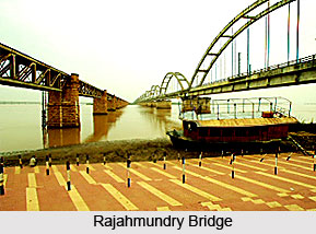
A period of political confusion ensued, rife with battles for control of the territory. Taking advantage of the disturbed conditions, a ruler of the Qutb Shahi dynasty, Sultan Quli Qutb Shah, invaded the coastal region and took possession of Rajahmundry and the neighbouring kingdoms. The last ruler of this dynasty was Abdul Hasan Tana Shas who ruled during 1672-87 A.D.
The rule of the Mughal dynasty started spreading to the South around this time. The district of East Godavari was then included in Golconda, which had become one of the twenty-two provinces of the Mughal Empire. The Mughal emperor Aurangzeb appointed viceroys to carry out the administration of these provinces. The Mughal emperor Farrukhsiyar appointed Nizam-ul-Mulk as the viceroys of the Deccan. Nizam-ul-Mulk`s death in 1748 A.D. led to a war of succession between his son Nasir Jung and his grandson Muzaffar Jung. The dispute ended with the accession of Salbat Jung, with the help of the French General Bussy.
Salabat Jung was subsequently deposed by his brother Nizam Ali Khan who leased out Rajahmundry and Chicacole to Hasan Ali Khan. Lord Robert Clive, entered into negotiations for the ceding of the Northern Circars and obtained a Firman to that effect in August 1765, but it was kept a secret till March, 1766. General Cillaud was sent to Machilipatnam to undertake military operations, if necessary. The Nizam also made brisk preparations for war. It was, however, prevented with the conclusion of a treaty whereby English agreed to hold the Northern Circars on payment of a tribute, accepting at the same time to furnish the Nizam with some troops. This treaty was confirmed by another treaty in 1768. Hasan Ali Khan`s lease expired in AD 1769 and Rajahmundry and Eluru came under the control of the newly constituted chief and council at Machilipatnam. The Zamindars came into prominence during the period preceding the transfer of the district to the English. The Zamindars of Rampa, Peddapuram, Pithapuram, Kota and Ramchandrapuram were the important Zamindars of this region.
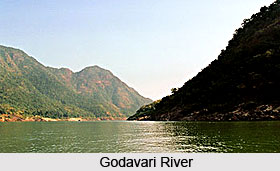
The East Godavari district today is a residuary portion of the old Godavari District after West Godavari District was separated in 1925. As the name of the district conveys, East Godavari District is closely associated with the river Godavari, occupying a major portion of the delta area.
Geography of East Godavari
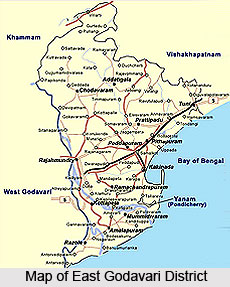
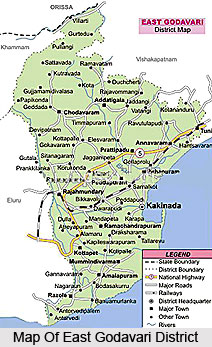 Geography of the East Godavari district, as the name suggests, is closely associated with the Godavari River which occupies a major portion of the delta area. East Godavari District lies between 16o 30" to 18o 20" North Latitude and 81o 30" to 82o 36" East Longitude. It is bounded by Vishakapatnam and Orissa on the North, Bay of Bengal in the South and East and West Godavari district in the West. Khammam lies to the Northwest. The entire east Godavari region can be broadly classified into three natural divisions. These are - the Delta, upland and Agency or hill tracts. The delta portion constituting the whole of Konaseema and portions of Kakinada, Ramachandrapuram and Rajahmundry erstwhile Taluks, presents a vast expanse of rice-fields surrounded by plantain, betel, coconut gardens and innumerable Palmyra`s. The upland areas are constituted by the erstwhile Taluks of Tuni, Pithapuram, Peddapuram and Portions of Kakinada, Ramachandrapuram and Rajahmundry. The general elevation of the East Godavari district varies from a few metres near the sea to about 300 meters in the hills of the agency. The Eastern Ghats mountain range rise by gradations from the level of the coast and spread throughout the erstwhile agency Taluks of Rampachodavaram and Yellavaram.
Climate in the region of the East Godavari district is relatively moderate throughout the year. The only exceptions are the months of April to June when the temperature reaches a maximum of 48 degrees. The normal rainfall of the region is 1280 mms. The majority of the rainfall, almost more than half of it, is brought by ten South West monsoons while a large portion of the rest of the district receives a rainfall from the North-East monsoon also. This happens during the months of October and November.
The main rivers of the region are the River Godavari, River Pampa, the Thandava and the Yeleru rivers. The soil in the district is mostly alluvial (clay loamy) red soil, sandy loam and sandy clay. There is mostly alluvial soil in Godavari delta and sandy clay soil at the tail end portions of Godavari River, red loamy soil in upland and agency area of the district. East Godavari is one of the agriculturally potential districts in the state of Andhra Pradesh. Situated in the Krishna Godavari Agro Climatic Zone, it contributes about 10% of the total food production of the State. The major crop of the district is paddy which is cultivated in both kharif and rabi as both irrigated and un-irrigated crop. Maize too is grown in both kharif and rabi. However pulses are concerned, black gram and green gram are the major crops. Among oilseeds, the major cultivations include those of Sesamum and kharif in both kharif and rabi. Other crops grown here include sugarcane and jowar.
Administration Of East Godavari District
 Administration of the East Godavari district is carried out in keeping with the norms of district administration. Accordingly, the Collectorate plays a pivotal role in district administration. The entire district is headed by a collector in the cadre of IAS officer.
He acts as the District Magistrate for maintaining law and order within his jurisdiction. The role of the Collector is mainly to deal with planning and development, law and order, scheduled areas/ agency, general elections, arms licensing etc.
The Joint Collector who also belongs to the IAS Cadre runs the administration of revenue under various enactments in the district. He is also designated as the Additional District Magistrate. His function is mainly to deal with civil supplies, land matters, mines and minerals, village officers etc.
Assisting the collector and Joint Collector in discharging their duties is the District Revenue Officer (DRO). He is responsible for looking after all the branches of the collectorate. He mainly deals with general administration and is vested with supervision of day-to-day functions of the Collectorate.
An administrative officer in the rank of a Tahsildar acts as general assistant to the Collector. He directly supervises all the sections in the Collectorate and most of the files are routed through him.
According to the Administrative reforms taken up by the Government of Andhra Pradesh, the Collectorate is divided into 8 sections. For the purposes of easy reference, an alphabet is given to each section.
Listed below are these different sections along with their corresponding alphabets.
1. Section A: Deals with Establishment and Office Procedure
2. Section B: Deals with Accounts and audit.
3. Section C: Deals with Magisterial (Court/Legal) matters.
4. Section D: Deals with Land Revenue and relief.
5. Section E: Deals with Land Administration.
6. Section F: Deals with Land Reforms.
7. Section G: Deals with Land Acquisition.
8. Section H: Deals with Protocol, Elections and Residuary work
Sub Divisional Office
For the purposes of administrative convenience, the entire region is divided into 5 sub-divisions. A sub division is headed by a Revenue Divisional Officer in the rank of a Deputy Collector or a Sub-Collector in the cadre of the IAS. He is the Sub Divisional Magistrate having jurisdiction over his division. He is assisted by an administrative Officer in the Cadre of a Tahsildar. The Sub divisional Offices are a replica of the Collectorate in the matter of number of sections. They act as a kind of intermediary in the entire administrative set-up. There are 81 divisions in Andhra Pradesh, each consisting of a few mandals whose performance is constantly being monitored by the concerned divisional office.
Mandal Revenue Office
Sub divisions are also found in the mandals. East Godavari District Consists of 60 Mandals. A Mandal is headed by the Mandal Revenue Officer (MRO). The MRO is vested with the same powers and functions as that of the Tahsildars of the erstwhile Taluks, including magisterial powers. The Mandal Revenue Office is headed by the Mandal Revenue Officer. He provides the interface between the government and public within his jurisdiction. He initiates welfare measures within his jurisdiction. The MRO assists the higher authorities in collecting information and conducting inquiries. He provides feedback to the district administration that helps in decision-making at higher levels of administration.
The deputy Tahsiladar supervises the day-to-day functions of the MRO`s office and deals mainly with general administration. Most of the files are routed through him. He monitors all the sections in the MRO`s office.
The Mandal Revenue officer assists the MRO in conducting enquiries and inspections. He supervises the Village Secretaries. He inspects the crop fields (Azmoish), writes Sharas (field inspection details) in Pahani, collects land revenue, non-agricultural land assessment and other dues and keeps close watch on the villages within his jurisdiction to maintain law and order.
The Assistant Statistical Officer (ASO), who is under the overall control of Chief Planning Officer at the District and Directorate of Economics and Statistics at the State Level, maintains data related to rainfall, crops and population. He conducts crop estimate tests. He inspects crops to submit crop condition details. He prepares periodical reports on births and deaths and assists the MRO in conduct of livestock census, population census and other surveys taken up by the government from time to time. MRO sends reports on above items to the District collector. Later these are sent to the department of economics and statistics and planning department at government level.
The Mandal Surveyor, who belongs to the Survey Settlement and Land Records Department, assists the MRO in survey operations. Chain Man assists Mandal Surveyor in his duties.
As per the administrative reforms the various sections in the MRO Office are:
1. Section A: Office procedure and financial activities
2. Section B: Land Related activities,
3. Section C: Civil Supplies, Pension Schemes etc.
4. Section D: Establishment, Natural Calamities,
5. Section E: Issue of Caste, income, nativity etc certificates.
Temples In East Godavari District
 Temples of the East Godavari district are many in number. A few of the most important ones are discussed below.
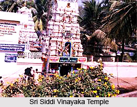
Sri Siddi Vinayaka Temple, Ainavalli
The Siddi Vinayaka temple is located at Ainavalli, in the Konaseema area of the lush - green fields of the River Godavari. Ainavilli is located at a distance of 72 Km from Kakinada, 55 Km from Rajahmundry and 14 Kms from Amalapuram. In a spacious, elevated area, this temple of Vinayaka stands with idol facing south. With two gopurams and gates, one can approach Vinayaka from the south and Sri Visveswara Swamy from the East. In the same compound is situated Sri Devi, Bhudevi with Sri Kesava Swamy. By the side are situated Sri Annnapurna Devi, Sri Kalabhairava Swamy and Kshetrapalaka are situated by the side. Special Pujas are performed at the temple every month on Chaviti, Dasami, Ekadasi days. During Vinayaka Chavithi Navarathri, Karthika Masam, Prabha festival on Sankranthi and Shivaratri special archanas are performed. Archanas are performed here everyday according to the Saivagama, Abhisheka is done regularly according to sastra. Thousands of people from far - off places throng the temple to worship Siddi Vinayaka. Devotees worship at the shrine of Lord Ganapathi, placed in the midst of coconut gardens, the green fields and natural surroundings.
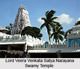
Lord Veera Venkata Satya Narayana Swamy Temple, Annavaram Annavaram is situated 32 Km from Pithapuram, 51 Km from Kakinada and 72 Km from Rajahmundry. It is famous for Lord Veera Venkata Satya Narayana Swamy temple, situated atop the Ratnagiri Hills on the banks of the river Pampa. One of the most popular temples in Andhra Pradesh, a unique Yantra based on Tripad Vibhuti Narayan Upanishad exists here. The shrine is constructed in two storeys, the lower one containing the Yantra and upper one housing vigrahas of the Lord. The idol which is about 4 metres high is in cylindrical form. The base in the lower sanctum represents Lord Vishnu and the middle portion represents Lord Shiva. The image of the deity forming a single idol and representing the Hindu Trinity is of unique attraction. In this temple premises, there is a sun dial which shows the Indian Standard Time. The Kalyana Mahotsavam of the deity at the Annavaram Satyanarayana Swami Temple, during May attracts thousands of pilgrims from all parts of the State.
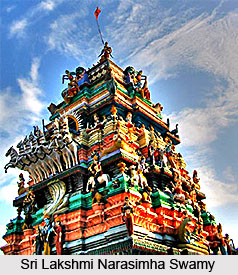
Sri Lakshmi Narasimha Swamy Temple, Antharvedi
 Antharvedi is located at a distance of 130 Kms from Kakinada, 100 kms from Rajahmundry and 65 Kms from Amalapuram. Antarvedi is said to be the second Varanasi by the grace of the Lord. There is a long history behind the construction of the temple, as it is said to have been made, destroyed and remade a number of times. It was finally set in place by a Sri Adinarayana, and completed by the combined efforts of his sons Ranganatha and Krishna. This is historically evident from a stone inscription in the temple even today. There are five important spots of this Holy shrine namely, the Sea, the Sagar Sangam, the Vasishta River, the Raktakulya River and the Chakrateertham. Performing ceremonial formalities to the ancestors at this holy-shrine is equivalent to those done at Gaya and Ganga River.
Antarvedi has the sea in the East and the South the Godavari in the West and the Raktakulya River the North. Special conveyance facilities are arranged for the convenience of the pilgrims coming from distant place to attend the annual Mela there. . People from distant place, like Varanasi, also visit this place, especially to participate in Lord Narasimha`s Chariot procession in the month of Phalguna (January) and dolepournami celebration in the month of Phalguna (March).
Sri Bala Balaji Devasthanam, Appanapalli
Appanapalli, a remote village in Mamidikuduru Mandal of East Godavari District, situated on the holy banks of river Vynateya has attained reputation as second Tirupathi of Konaseema being the abode of Lord Bala Balaji. It is Located at a distance of 70 Km from Kakinada. The village Appanapalli derived its name after a Rushi called "Appana" who did thapassu for the good of the world. This place in olden days was famous for well-read Brahmins in Vedas who used to spend their time in reciting hymns and performing sacrifices as ordained in the scriptures.
 The founder of the present Bala Balaji Devasthanam is Sri Molleti Ramaswamy an ardent devotee of the Lord of the seven hills. One night he saw in his dream the Lord ordering him to go ahead with his samkalpa of building a temple for the Lord at Appanapalli without coming to Tirupathi with the share of profit in his business for the Lord annually. Accordingly Sri Ramaswamy at once installed the photos of Sri Sri Sri Venkateswaraswamy varu and his consort Padmavathi Ammavaru in his coconut shop in 1966. In course of time pilgrims in thousands started pouring in and Appanapalli occupied a place of devotional importance in the pilgrim map of the state. On 18th March 1970, Ekadasi Wednesday at 10.10 A.M. the foundation stone for the construction of the New Temple was laid by Sri Ramaswamy amidst the chanting of Mantras by the Vedic Scholars. On 4.7.1991 the New Temple was completed. Strictly in accordance with the Panchahnica Agama Sastra in which, His Holiness Sri Sri Sri Tridandi Srimanarayana China Jeeyar Swamy varu installed the idols of the Lord and his consort. Maximum care is taken for the convenience of the pilgrims who visit the temple in great numbers.
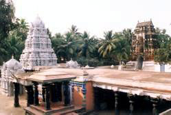
Sri Golingeswara Swami Vari Temple, Biccavolu
This temple is located at a distance of 33 Km from Kakinada, 40 Km from Rajahmundry and 60 Km from Amalapuram. Biccavolu is known for Beautiful stone temple of Lord Shiva. Built by the Eastern Chalukya dynasty in the 9th-10th centuries, the temples are a fine example of the architectural grandeur that was typical of the Dravidian style. A stone sculpture of Lord Ganesha in the village is a masterpiece of Chalukyan craftsmanship.
Located in the village of Biccavolu are a number of beautiful temples belonging to the Eastern Chalukya period. Some of them are the Sri Rajaraja Temple, Sri Chandrasekhara Swamy and three temples of Shiva situated in the fields of the Village. An eleven foot monolithic statue of Lord Ganesh is also found in the fields, a top draw for tourists.
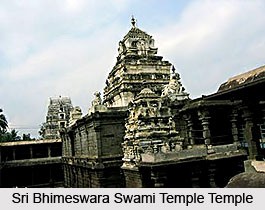
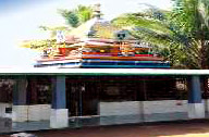
Sri Bhimeswara Swami Temple, Draksharama
Draksharamam is located 28 Km from Kakinada, 50 Km from Rajahmundry and 25 Km from Amalapuram. It is a pilgrim site situated on the Eastern Bank of the River Godavari. It is colloquially known as Draksharama carrying the implied meaning as "Draksharama" meaning the Abode of Daksha Prajapathi - the Father-in-law of Lord Siva and the beloved Father of `Sati` the spiritual spouse of Lord Siva. The history of the Sacred Pilgrimage is exhaustively dealt within the `Skanda Purana` of Sri Vyasa. This Holy Pilgrimage is one of the rare few, where the God and Goddess are equally important. The Lord`s existence here is said to be a swayambhu. Celebration of Sri Bhimeswara Swamy varu, Subrahmanya Shasti, Maha Sivaratri and Kalyanam etc., are the important festivals of this Temple. The temple is a protected monuments and its renovation has been undertaken by the Archaeological Department.
Sri Suryanarayana Swamy Temple, G.Mamidada
This temple is a well - known pilgrim centre of the East Godavari district for the last hundred years, situated on the banks of the river "Thulya Bhaga" (Antharvahini). All over Andhra, Gollala Mamidada is called "Gopurala Mamidada". Found here at this holy place are the famous "Rama Temple" with its towering (Gopuras), the famous "Surya Temple" (The second Surya Temple of A.P after Arasavilli), "Venkateswara Temple, Sainatha Temple" and also the ancient and the famous "Bheemeswara Temple".
Sri Suryanarayana Swamy Temple at Gollalamamidada village was incepted by late Sri Kovvuri Basivi Reddy Garu in the year 1920, a great Charitable Jamindar of Gollalamamidada. This temple owns 16 Acres of wet land donated by successors of late founder for the maintenance and up - keep of the temple. The performance of rituals in this temple is in accordance with Sri Vyshanava Samradaya. This temple has gained much importance in Andhra Pradesh as the tenets are of Vyshanava Sampradaya. It is attracting good number of pilgrims all days and especially on Sunday to pray their Owings to Lord Sri Suryanarayana Swamy Varu. This temple was classified U/s.6 (b) (ii) of the Act 30/87 and it is under the administrative control of the Deputy Commissioner, Endowments Department, Kakinada.
Amalapuram
This picturesque village 65 Km from Kakinada via Yanam offers easy access to other places of tourist interest such as Vigneswara temple at Ainavilli, Vireswara temple at Muramalla, Uma Koppulingeswara Swamy temple at Palivela, Sri Skhana Mukteswara Swami temple at Mukteswaram, Allavaram beach and Aduru a Buddhist site.
Apart from the above-mentioned temples, a number of temples are found at Korukonda, Kotipalli, Mandapalli, Muramalla, Palivela, Peddapuram, Pithapuram, Rajahmundry, Ryali, Samalkota, Sarpavaram, Talupulomma Lova and vanapalli. These are a rich legacy of the historical and religious tradition of the place and well worth a visit when travelling to ten East Godavari district.
 Saneeswara Temple
Location: Mandapalli near Rajamundry, East Godavari.
Deities: Saneeswara
Also known as Sri Mandeswara Swami Temple and Someswara Temple, it is said that Saturn himself consecrated the linga representing Lord Shiva here. Other deities here are Bhrameswara and Nageswara enshrined in black stone Shivlingas. There is a shrine to Saturn - Saneeswara. This is a small temple attracting a large number of pilgrims.
Legend: A great sage Dhadichi gave a great sacrifice by donating his spinal cord for Lord Indra`s `Vajra` to relieve the people from the tyranny of the demon Kartabha. However, the sons of the demon Aswartha and Pippala vowed revenge and created havoc in Mandapalli. Sage Agastya approached Lord Shaneeswar or Saturn with the request for help but Shani stated that till the prayers and penance was completed, he would not have strength to fight and get rid of the demons. He relented when sages agreed to give their `Tapasshakti` (power of penance) to him. He fought and killed the demons and relieved the people of their tyranny. Saturn installed a `Shiva Linga` known as `Someswara` or `Mandeshwara` to mark his victory, around which the Saneeshwara temple is built.
Kesava Swami Temple
The Shrine is Salagrama Ekasila and is 5 feet in height and 3 feet wide, with the image of Jaganmohini, the female aspect of Vishnu in the rear. This temple is said to date back to the period of the Cholas. The idol is made of black stone depicting Maha Vishnu and Mohini in the front and rear sides, and is a marvel of sculptural dexterity. The ten incarnations of Vishnu with consorts are beautifully, sculptured around the shrine. A rare feature is that, Ganga flows from the feet of Vishnu and is the origin of Akasa Ganga, which can be seen here.
Golingeswara Aalayam Temple
Location: Ramachandrapuram, East Godavari
Deity: Lord Siva
There are three temples here facing east and are called Golingeswaraalaya, Rajarajeswaraalaya and Chandrasekaraalaya - all dedicated to Siva. Of the three, Golingeswaraalayam is the biggest and grandest because of the sculptures. The Sivalinga installed in Golingeswaraalayais is made of black granite and is very tall and highly polished. The temple also enshrines Subrahmanya in a niche and is called Subbarayudu. There are anthills with serpents all around that are also worshipped. People come here and offer prayers for ten to 40 days to get relief from earache and get Santanaprapti.
Kapoteswara Aalayam Temple
Location: Razole (Rajolu), East Godavari
Deity: Lord Siva
Siva linga is worshipped in the form of a dove or kapotha. Hence, the name Kapoteswaraalayam. The Sivalinga has two doves over it and there is a tank called Kapotagundam.
 Legend: The two doves sacrificed their lives for the benefit of a hunter. A serpent used to come from the tank and worshipped the Lord. And since that time, the temple authorities introduced the Subrahmanya Shasti, a special prayer service.
Koppulingeswara Swamy Aalayam Temple
Location: Palivela near Kottapeta, East Godavari
Deity: Lord Shiva. This Sivaalaya owes its existence to the sage Agasthya.
Legend: A certain priest was known for his higher learning, but was notorious for his passion for flesh. He worshipped the Lord regularly with garlands worn by his ladylove. The King suspected it, when he found the garland containing a long hair. Insisting on the truth, the priest hoodwinked the King, saying that the Sivalinga has a braid. The King left desiring to see it the next day. The priest wailed and called out to the lord. Pleased with his devotion, the Lord gave darsan to the King with a braid. The King bestowed many valuables and lands on the priest. The temple houses other deities too.
Kukkuteswara Swamy Aalayam Temple
The presiding deity reveals himself in linga form and is in white marble stone about two feet in height. The linga resembles the back of cock; hence Lord Siva is called Kukkuteswaraswamy. He fulfils the desires. It is a Swayambhu linga and water trickling down in a pot from his nose. Vyasa worshiped this murti for a very long time.
Annavaram Satyanarayana Swami Temple
The temple is dedicated to Lord Satyanarayanaswami where this Vratham is performed. This temple is dedicated to Veera Venkata Satyanarayana Swami and is built atop the Ratnagiri. The temple resembles a chariot. The distance from the foot of the hill there is a path laid out in stone steps.
 Bheemaramam Temple
Location: Samalkot near Kakinada, in East Godavari District of AP. It is also known as Kumararamam.
Deity: Shiva
Legend: When Subramanya killed the demon Tarakasura, the Shivalingam in the demon`s throat broke and fell in five different spots, which became the Panchaarama kshetras. The foremost is Amareswara at Amaravati where Indra and other gods are said to have worshipped Shiva. The others are Draksharama, Somarama at Kotipalli, Bheemarama at Kakinada and Ksheerarama or Palakollu. The Shivalingam was installed here by Skanda and hence the name Kumararamam. There are puranic references to Kumararamam in the Skanda Purana.
Architecture: The Shivalingam is large and is housed in a three-storied sanctum, and worship is performed in the upper level. The sculptures are worth a mention. There is intricate work done in stone. For eg. a black granite swing here actually sways when rocked.
Someswara Temple
The place is famous as the seat of the temple of Bhimeswaraswami. The temple is a perfect blend of Chalukya and the Chola styles of temple architecture. There are 381 inscriptions from Saka 1002 (1080 AD) to Saka 1356 (1434 AD).
Someswaram Temple
Found at the origin is the Tryambakeshwar Jyotirlinga shrine thus the worship at Someswaram is associated with a ritual bath in the river Godavari. Draksharama is one of the pancharaama shrines, and is associated with the legend of the destruction of (the vain) Daksha`s ritual sacrifice. The ritual bath in the river is symbolic of a new beginning in life, a change in direction.
Economy of East Godavari
Coconut Plantation is a major source of subsistence for the people belonging to the district of East Godavari. In order to use natural resources to enhance economy of the district, the Andhra Pradesh has employed a large number of females in the `Coir Project`. Maximum number of people in the East Godavari district earns their living from the Andhra Paper Mill, the Godavari and Nagarjuna Fertilizers, the Plywood unit at Rampachodavaram, Sugar factories at Samarlakota and people are also engaged with a number of dairies, hatcheries, piggary farms, fisheries, spinning and saw mills. The handicraft industry is also well flourished in East Godavari. Bell metal crafts are a common handicraft industry of the district. Some other small scale industries which have flourished in the district of East Godavari are the making of musical instruments.
Tourism In East Godavari District
 Tourism in East Godavari district is all about the beauty of nature. The district abounds in a number of places which are resplendent in their natural beauty, and rich in their display of flora and fauna. The prime attractions of tourism in the East Godavari district are listed below.
Coringa
Coringa is home to a beautiful sanctuary. It is at a distance of about 15 Km from Kakinada on Kakinada Yanam Road. Coringa Sanctuary, named after a tiny village Coringa in East Godavari District of Andhra Pradesh a part of Krishna Mangroves was declared as a wildlife sanctuary by Govt. of Andhra Pradesh vide G.O.Ms.No - 484. Forests and Rural Development (For.III) Department dated 5-7-1978 was to conserve the mangrove vegetation of the estuary, extending to an area of about 235 Sq. Kms. It is located between 16o-30` to 17o-00` N latitudes and 82o-14` to 82o-23`E longitudes.
Mangroves are salt - tolerant forest ecosystems of tropical and sub - tropical intertidal regions of the world. They normally occur between high water levels and near about mean sea level along the sheltered shores, estuaries, tidal creeks, back-waters, lagoons, marshes and mud-flats. Mangroves contain a highly specialised community of plants associated with animal species which are not capable of surviving in any other situations.
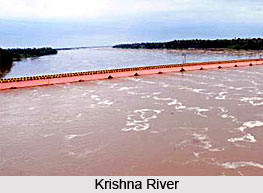
Mangroves occur in Andhra Pradesh in estuaries of Krishna River and the Godavari River. Andhra Pradesh has got an area of 582 Sq km of Mangrove forests, accounting for about 9% of local forest area of the State.
The fauna and flora found in these Mangrove forests is rather unique. This is because the mangroves provide certain unique conditions which are conducive to the growth of these plants and animals. The crowns of trees including trunk, branches, leaves, flowers and fruits provide niches essentially, to terrestrial fauna like birds, mammals and insects. The soil surface of mangroves provide niche for mudskippers, crabs and molluses. The water in the forest supports a variety of animals like the smooth Indian Otters (Mud skipper, Crab) Jackal Monkeys and Fishing cat. The Sanctuary has a unique distinction of having an 18 Km. long sand spit in the North Eastern side, where the species of Olive Ridley sea turtle (endangered species) nests during January - March every year.
 Apart from these animals, mangroves invariably attract large populations of birds which feed on various organisms occurring in the mangrove forest and in the back water. Over 120 species of birds are reportedly found in the sanctuary. This sanctuary is easily accessible from Kakinada in the East Godavari District of Andhra Pradesh. The Kakinada town is well connected by rail and road. The sanctuary can be visited from places viz; Chollangi, Matlapalem or Ramannapalem which are located on Kakinada to Yanam Road about 10 - 15 Km distance from Kakinada. The visiting season is from December to June and it can be accessed by boat as well as by foot.
Dowleswaram
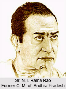
Dowleswaram is best known for the Sir Arthur Cotton Museum located here. It was inaugurated in 1988 by the Hon`ble Chief Minister of Andhra Pradesh Sri Nadamuri Tarakarama Rao. The Museum is located in the building which was previously under the occupation of Executive Engineer, Godavari Head Works Division Dowleswaram. This museum was started with an intention to educate the people about how the great Engineer Sir Arthur Cotton during those olden days constructed the mighty anicut across Godavari River and converted the lands of East and West Godavari District as very fertile. The Museum also narrates the construction of present Sir Arthur Cotton Barrage constructed with the advance engineering skill. A number of models collected from various places and projects have been exhibited in the museum to attract the visitors and to make them understand various items connected to irrigation works. Besides the above, a number of lawns, flower plants, croton plants, and decorative plants, in the garden around the Museum contribute to the pleasant Greenery. The museum is visited by a number of visitors from other states and countries as well as students of engineering institutions. The museum charges a nominal entry fee of rupee1.00 per child and Rs.2.00 per adult. Rupees five has been fixed as the price for photography.
Kadiapulanka
Kadiapulanka, abutting the National Highway-5 and 20 Km from Rajahmundry is the hub of nurseries of myriad varieties of flowers and fruits. Since the past four years, flower festivals are being organised here. Kadiam nurseries are spread over a radius of about 10 Km comprising the villages of Kadiam, Kadiapulanka, Burrilanka, Veeravaram, Pottilanka, Venkatayammapeta and Damireddipalli. The nurseries in Kadiam are as old as 100 years and at present there are more than 600 nurseries, the extent of each ranging from just 0.5 cents to 200 acres. In Kadiam nurseries alone, more than 25,000 people are engaged in the 600-odd nurseries. Nursery products from Kadiapaulanka are exported to every nook and corner of the country.
 The all India Nurserymen`s Conference is organised at Kadiapulanka and it has become a mega event, with people in tens of thousands visiting the flower festival daily. The nursery is a must see visit in the tourism of the East Godavari district.
Maredumilli
Another major tourist attraction of the east Godavari are the Maredumilli forests of East Godavari District. They have a rich biodiversity and the area has semi evergreen forests with undulating terrain, which forms part of the Eastern Ghats mountain range. The Maredumilli Community Conservation & Eco Tourism Area is situated on Maredumilli - Bhadrachalam road, nearly 4 Km. away from Maredumilli village. There are many streams flowing through the area over the undulating rocks in the deep woods. The Eco-tourism project is managed by the local indigenous tribal community of Valamuru, Somireddypalem and Valmeekipeta Vana Samrkshana Samithi people with the active support of Andhra Pradesh Forest Department. This also provided a unique opportunity to the native ethnic community to spread the message of conservation to the masses. The jungle star campsite is located adjoining the Valamuru River with the stream flowing on 3 sides overlooking the Vali-Sugriva Konda which is believed to be the battle ground of the Vali-Sugriva during the Ramayana period. As a part of Tourism Development Maredumilli Forest Rest House was constructed in the year 1914, the Forest Rest House is in Maredumilli Village with all facilities. The name of the rest house is Abhayaranya Forest Rest House. Suits are available here for stay of Tourists.
Masaani Tippa
Forest Department, Government of Andhra Pradesh started Eco Tourism Project at Maredumilli, Rampa Agency areas and at Massani thipa costal area with an intention of letting the people know about the development and protection of forest area of Kakinada Territorial Forest Division. Eco tourism at Rampa consists of the Amruthadhara Water Fall at Rampa Forest Area and the statue of Lord Shiva at Deep Forest of Rampa Forest Area.


