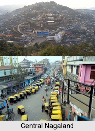
Districts of Central part of
Nagaland include
Zunheboto District, Dimapur District and
Tuensang District.
The central part of Nagaland is full of natural beauty and serenity. This will always be every adventurer"s dream. The breath taking hillock, the striking mountains, the beautiful streaming lakes are picture perfect. In the central area of Nagaland, a stream or lake will be there to surprise one every time and one will decide to go for a trek out in the wilderness. There are several brooks and tributaries, flowing freely within the state making the trip Nagaland a truly memorable one.
Zunheboto District : Zunheboto District is a district of Nagaland state in India. It is located in the central part of Nagaland. "Zunheboto" derived its name from two sets of words "Zunhebo" and "To" in Sumi dialect. Zunhebo is the name of a flowering shurb with white leaves, which bear sponge like ears containing sweet juice, and "To" means the top of a hill. Zunheboto District is the home of the Semas Tribe. They are famous for their colourful war dances and folk songs. Sumis in general in those days had so many traditional festivals in sequence of seasons of the year. Even these days, two main festivals, Tulunih Festival and Ahunah Festival are celebrated with gaiety and grandeur by young and old. These two festivals also promote the tourism sector here.
Dimapur District : Dimapur District is a district of Nagaland state in India. Its headquarters is Chumukedima. As of 2011 it is the most populous district of Nagaland.
Dimapur Jain Temple was built in 1947. This is one of the prime attractions here. The temple is architecturally very well built and has an impressive structure. The temple has some intricate glasswork. The temple is considered very auspicious by the people of Dimapur. The temple was built by the tireless effort of Shri Nandlal Mangilal Jain and his family, Shri Kanhaiyalal Pannalal Sethi and family, Shri Phulchand Sethi, Shri Jethmal Sethi, Shri Udayram Chabra, Shri Chunnilal Kishanlal Sethi, Mangal chand Megh raj family and other Jain families present in Dimapur at that time. During the Second World War, Dimapur was the centre of action between British Government in India,
Azad Hind Fauz and the Imperial Japan. It was the staging post for the Allied Offensive. The Japanese could reach Kohima where a siege was laid. The Allied reinforcement came through Dimapur by rail and road for the push against the Japanese. An airport at Dimapur was also in use for supplies to the allied forces in Burma. The battle for
Kohima about 77 km from Dimapur is considered the turning point for the retreat of Azad Hind Fauz led by
Subhas Chandra Bose and Japanese Army from South East Asia.
Tuensang District : Tuensang District is the largest and the eastern most district of Nagaland, a state in North-East India. Its headquarters is Tuensang. This district is known as the land of culture. Tuensang District is located in the eastern part of Nagaland. It is bounded by Mon District and Longleng District in the north and north east respectively, Mokokchung District in the northwest, Zunheboto District in the southwest,
Kiphire District in the south, and Myanmar in the east.
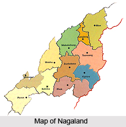 Nagaland has 11 administrative districts. Nagaland is a vibrant hill state located in the extreme North Eastern end of the country. This state is bounded by Myanmar in the east; by Assam in the west; by Arunachal Pradesh and a part of Assam in the north with Manipur in the south. Districts of Nagaland are headed by district magistrates or deputy commissioners. Each district is under the administration of a deputy commissioner and he is assisted by other officials, who are in charge of the different wings of the district administration. Maintenance of law and order in a particular district of Nagaland is the responsibility of Superintendent of Police.
 Districts of North
  Districts of South


