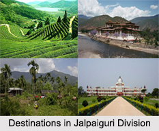
 Districts of Jalpaiguri Division in West Bengal include the districts like Darjeeling District, Jalpaiguri district, Alipurduar District and Cooch Behar district. This division in West Bengal has the hill stations, mountain ranges and the wildlife sanctuaries.
Darjeeling District
Darjeeling District is the northernmost district of the state of West Bengal in eastern India in the foothills of the Himalayan Mountain Range in India. Darjeeling District is famous for its hill stations and Darjeeling tea. Darjeeling is the district headquarters. Kalimpong, Kurseong and Siliguri, three other major towns in the district, are the sub divisional headquarters of the district. Mirik, another town of the district, has been developed as a lake resort since the late 1970s. Darjeeling hill area is formed of comparatively recent rock structure that has a direct bearing on landslides. The heavy monsoon precipitation contributes to the landslides. The soils of Darjeeling hill areas are extremely varied, depending on elevation, degree of slope, vegetative cover and geolithology.
Jalpaiguri District
Jalpaiguri district is a district of the Indian state of West Bengal. It is situated between 26 degree 16 minutes and 27 degree 0 minutes North latitudes and 88 degree 4 minutes and 89 degree 53 minutes East longitudes. Jalpaiguri district was established in 1869 in British India. The headquarters of the district are in the Indian city of Jalpaiguri, which is also the divisional headquarters of North Bengal and has its special importance in respect of tourism, forest, hills, tea gardens, scenic beauty and commercialization and business. Jalpaiguri district comprises western part of Dooars and the major part of the eastern Morang; and this area, in the ancient time was a part of the kingdom of Kamrup, and since the middle of the seventh century it became a part of the Kingdom of Kamatapur.
Alipurduar District
Alipurduar District is the 20th district in the state of West Bengal, India. It consists of Alipurduar municipality, Falakata municipality and six community development blocks: Madarihat–Birpara, Alipurduar–I, Alipurduar–II, Falakata, Kalchini and Kumargram. The six blocks contain 66-gram panchayats and nine census towns. The district has its headquarters at Alipurduar. It was made a district on 25th June 2014. Alipurduar District was bifurcated from Jalpaiguri district and made a separate district on 25th June 2014. Buxa Tiger Reserve, Jayanti Hills, Buxa Fort, Chilapata Forest, Jaigaon, Rajabhatkhawa and many more are the tourism destinations in Alipurduar District.
Cooch Behar District
Cooch Behar district is a district of the state of West Bengal, as well as the district`s namesake town. During the rule of British East India Company and later the British Government in India, the town of Cooch Behar was the seat of a princely state of Koch Bihar, ruled by the Koch dynasty.


