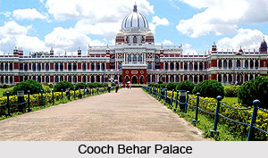
 The district of Cooch Behar is situated in the north-east corner of the state of West Bengal. It is surrounded by the Jalpaiguri district in the north and north-west, the state of Assam in the East and the international boundary of the Indo-Bangladesh border in the south and south-west. Beside this bounded area there are enclaves (called Chhits) which are outlying and detached tracts of land situated inside Bangladesh. The independent Koch kingdom has been the most active component in determining and making the history of the district of Cooch Behar. Cooch Behar is well known for the beautiful Raj Bari situated here, the grand and majestic palace of the former Koch rulers.
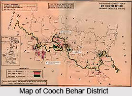
Location of Cooch Behar District
Cooch Behar is situated in the North-Eastern part of the state of West Bengal. It lies between 26 degrees 36 minutes and 25 degrees 57 minutes north latitude and between 89 degrees 54 minutes and 88 degrees 47 minutes east longitude. It is bounded by the Jalpaiguri district in the North and north-west and the state of Assam in the east (the districts of Kokrajhar and Dhubri in Assam). In the South and South west lies the international border in the form of the Indo-Bangladesh boundary. Beside this bounded area there are enclaves (called Chhits) which are outlying and detached tracts of land situated inside Bangladesh. There are 110 such Chhits.
History of Cooch Behar District
It has been seen that the ancient territory of Kamrup played a very important role in the development of the present region of Cooch Behar district in West Bengal.
 During the 15th century AD, the western part of Kamrup came under the sway of the Khen dynasty to usher a new kingdom there known as Kamta. The present Cooch Behar owes its origin to this Kamta land. It is widely believed that king Maharaja Viswa Singha was responsible for the establishment of an independent `Koch` kingdom in 1510 AD or 1530 AD. The Mughal forces grabbed certain portion of the `Kamta` kingdom in the middle of the 17th century AD. Later on the accounts of Badshanama, Shah-Jaha-nama, Tarikh-I-Assam and the Alamgirnama ascribed this territory as Cooch Behar. It is, therefore, very much apparent that the Koch kingdom was known as Kamta even during the middle of the 17th century AD when the Koch kings like Maharaja Viswa Singh, Maharaja Nara Narayan and Maharaja Pran Narayan used the title `Kamteswar` for themselves.
Geography of Cooch Behar District
Cooch Behar district is located between 26 degrees 36 minutes and 25 degrees 57 minutes north latitude and between 89 degrees 54 minutes and 88 degrees 47 minutes east longitude. The total area covered by the district is 3387 sq. kms, which contributes 3.82 percent of the land mass of the State of West Bengal. There are six main river systems which cut through the district, and all of them flow in a south-easterly region. From the west to east these are: the Teesta river system, Jaldhaka river system, Torsa, Kaljani, Raidak river and Gadadhar river system. The climate of the Cooch Behar district is characterised by an extremely humid atmosphere with abundant rains. The temperature is hardly ever excessive. January is the coldest month with temperature varying between 10.4 degrees Celsius to 24.1 degrees Celsius, and April is the hottest month with mean daily maximum of 32.5 degree Celsius and mean daily minimum of 20.2 degree Celsius. Average annual rainfall in the district is 3,201.3 mm. Flora in the district comprises of palms, bamboo, creepers, ferns, orchids, aquatic plants, fungi, timber, grass, vegetable, fruit trees, etc.
 Education in Cooch Behar District
The educational scenario in Cooch Behar district is fairly good. Educational facilities are high in number. There are a total of 1805 primary schools found in the district and 120 high schools. Other educational systems here include- 60 junior high schools, 61 higher secondary schools, 5 high madrasas, 9 general colleges, 2 engineering and technical schools, 16 professional schools and even one blind school. In the entire region an average of 13, 86, 965 form the literate population.
Economy of Cooch Behar District
Agriculture is the main source of income in the district. Favourable climate has allowed agriculture to flourish in the Cooch Behar district. Among the crops grown here, wheat is one of the most important crops grown in the Rabi season. Pulse is another important cereal crop and attempts have been made to increase the productivity as well as production. The district is marginally surplus in rice production. Animal resource farming and dairy activities also contribute towards the income of the district. Among the industries, the main ones are cold storage, fruit processing, jute processing, oil extraction, mini rice mill and paddy husking.
Tourism in Cooch Behar District
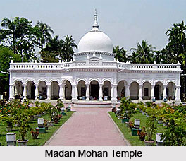
The most famous tourist spot located in the Cooch Behar district is the Raj Bari- the palace of the Koch Maharajahs. It is a beautiful palace constructed in the Classical Italian Renaissance style, on orders of Maharajah Nripendra Narayan. Since Cooch Behar is primarily a Hindu-majority district, a number of beautiful temples are found here. Of the various temples located here, the most outstanding temple is the Madan Mohan Temple constructed by Maharaja Nripendra Narayan. Others include Brahmo mandir, Dangar Aayee temple, Siddheshwar temple, Kamteshwari temple, Siddhanath Siva Temple and many more.
Cooch Behar District
Cooch Behar District is situated in the state of West Bengal. Located here is the famous Raj Bari, a popular tourist attraction and the former palace of the Koch kings of Cooch Behar.


