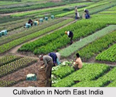
 Cultivation in North East India is basically influenced by the physiographic conditions having varied topography, different soil types, uneven distribution of temperatures, rainfall etc. The region is also lagging behind in development. About three-fourth of the population of North East India, depends on agriculture and other related activities. Rice and maize are the leading crops in both hilly regions and plain areas.
Types of Cultivation in North East India
The cultivation practices of North East India are of three types:
•Shifting or Jhum Cultivation
•Settled or Plains Agriculture
•Terrace Cultivation
Shifting or Jhum Cultivation: As a large part of the region has hilly features settled by different tribal groups, shifting cultivation is the utmost customary which is the rudimentary life supportive subsistence intensive agriculture. Shifting cultivation is commonly practising in hilly red soil and laterite soil region. They are mostly practise by tribal people in all districts of Arunachal Pradesh, hill region of southern Assam, mountain areas of Tripura, Mizoram, Nagaland and Kukis and Nagas in the hill regions of Manipur. The region is known for "slash and burn" type of shifting cultivation.
Settled or Plains Agriculture: The plain or settled agriculture is generally practise in fertile alluvial plains of Assam, plain areas of south eastern Nagaland, Brahmaputra plain in southern Arunachal Pradesh, Barak Valley and some plain areas of Tripura and the central Imphal Valley of Manipur. A few of the tribes of Arunachal Pradesh such as the Apatanis, the Singphos and the Khamptis have been practising settled cultivation for longer periods since they settled in river valleys and plateaus with suitable terrain.
Terrace Cultivation: Terrace Cultivation is practiced in valleys and foothills, and inside plantation forests. This is being practiced for last three decades, to provide improved production system, to conserve soil moisture and also to prevent land degradation and soil erosion. In this system, bench terraces are constructed on hill slopes where the cultivation is practised.
Thus, the Cultivation in North East India is not much similar to the other parts of the country. The modern agricultural inputs used in agriculture are comparatively low.
Cultivation in North East India
Cultivation in North East India is characterised with diversified agro-climatic condition, different soil types and irregular physical features. Jhum Cultivation and Settled Cultivation are mainly practised in the Seven Sisters States.


