
 The state of Uttarakhand is located in the northern part of India, more specifically, in the Himalayas. This state has a total of 13 districts. It has some of the holiest Hindu shrines, rivers like Gangotri and Yamunotri, ancient temples, nationally protected monuments, forest reserves, national parks, hill stations and mountain peaks. They have not only beautified this state but have also made Uttarakhand one of the famous tourist destinations of India. To reach the "Land of the Gods" or Devbhumi namely Uttarakhand, a number of airports have been established in the state.
Jolly Grant Airport
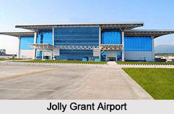
Jolly Grant Airport or Dehradun Airport is located about 22 km southeast of Dehradun, in the foothills of Himalayas. This airport is operated by the Airports Authority of India. It was constructed in the year 1974. This airport has been provided with a new domestic terminal building. It was inaugurated in February, 2009. The terminal has the potential to handle 150 passengers during the peak hour. Its annual handling capacity is about 122,000 passengers. The apron of this airport can accommodate 2 category `C" type of aircraft.
 Jolly Grant Airport was involved in rescue operations during Uttarakhand floods in the year 2013. In order to evacuate pilgrims from Kedarnath and the surrounding pilgrimage sites, the flight handling capacity of this airport was extended from 16 flights a day to more than 100 daily flights on some days.
Bharkot Airport
Bharkot Airport is located in Chinyalisaur of Uttarkashi district. This airport is also utilized by the Indian Air Force as an Advanced Landing Ground (ALG). Bharkot Airport is also known by the other name of Chinyalisaur Airstrip.
Naini Saini Airport
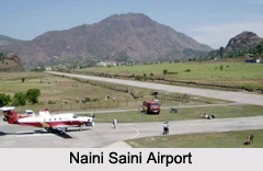
Naini Saini Airport is situated in Pithoragarh. This airport was constructed in the year 1991. Earlier this airport was planned for the operations of Dornier 228 type aircraft. The State Government plans to upgrade it to Category 2C airport under Visual flight Rules (VFR) conditions in order to facilitate operations of ATR-42 type of aircraft.
Pantnagar Airport
Pantnagar Airport is located in Pantnagar of Udham Singh Nagar district. This public airport is operated by the Airports Authority of India. For the people visiting the Kumaon hill stations of Nainital, Bhimtal, Ranikhet and Almora and the Jim Corbett National Park, Pantnagar Airport serves as the nearest airport. Since 1st of October, 2014, daily Air India Regional flights to and from Indira Gandhi International Airport in Delhi started operating in Pantnagar Airport. Airport Advisory Committee in August, 2015 said that the length of this airport"s runway will be increased from 1,372m to 1,865m.









