Introduction
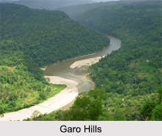 Garo Hills are a part of the range that is called the Garo-Khasi range in Meghalaya. The range is part of the Meghalaya subtropical forests eco-region. It is one of the wettest places in the world. Situated close to the Indo-Bangladesh Border, the Garo hills are part of the Patkai hill range, which extends across the Indo-Myanmar border. The greater part of Garo Hills ranges in height from 450m to 600m and drops steeply to the Brahmaputra Valley on the north and to the plains of Bangladesh on the south.
Through the Garo Hills, two mountain ranges pass, called the Arabella Range and the Tura Range, which forms the great Balpakram Valley in between. Balpakram area is considered to be sacred for the Garo community due to their belief that the spirits of the dead sojourn here. The Nokrek Peak is the highest point in the Garo Hills, which is covered by a thick film of lush forest. The hills are also decked with splendid waterfalls, enriching the environmental coherence of the place.
Flora and Fauna of Garo Hills
Garo Hills are known for its abundance of wildlife with a unique range of flora and fauna. The Nokrek National Park comprises herds of wild elephants, many rare varieties of birds and pheasants along with rare orchids. Garo Hills is densely forested and hence one of the richest spots in bio-diversity.
Divisions of Garo Hills
 The Garo Hills have an area of approximately 8,000 sq. Kms which forms the western part of Meghalaya. Garo Hills comprises 5 districts; North Garo Hills, East Garo Hills, West Garo Hills, South Garo Hills and South-West Garo Hills. West Garo Hills is one of the largest districts of Meghalaya located in the western part of the state. Tura is the largest town having a population of 70,000.
Tribes of Garo Hills
The Garo Hills are mostly dominated by the tribes known as Garos. The Garos call themselves Achik-mande. In the Garo language Achik means "Hills" and mande means "Man". So, Achik-mande means the Hills people.
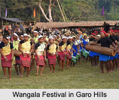
Festivals in Garo Hills
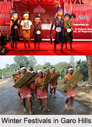 Winter Festival in Garo Hills comprises of three days festival that takes place at Ampati in West Garo Hills, Resubelpara in North Garo Hills and at Tasek in East Garo Hills. At Ampati two events are held simultaneously, namely the Dimchrang and Kite Festival. Resubelpara holds the Awe Festival and Tasek Festival in Tasek. In all the festivals, the cultural mosaic of different communities was showcased.
Celebration of Winter Festivals in Garo Hills
The cultural parade and carnival was led by Dimchrang troupe followed by a skill troupe from Manipur. At least 11 troupes displayed their cultural lifestyle of different communities – Koch, Hajong and Garos at Ampati.
The Winter Festivals in Garo Hills gives a platform for the locals to take part in different activities and showcase their skills.
Tourism in Garo Hills
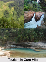 Tourism in Garo Hills known for its abundance of wildlife attracts adventure lovers with sights of a unique range of flora and fauna. There are various amazing landscapes of hills against a backdrop of low-lying plains. There are several places in Garo Hills that has been developed for tourism. Some of them are of historical importance; others are important because of their association with the cultural traditions of the Garo people and many of them have famed for their scenic beauty.
Some of the famous places of Tourism in Garo Hills are as follows:
Tura Peak: A sunset view can be best seen from Tura Peak at 1,400 m and its summit can be reached by a taking a 5 km adventure trek and partly by hiking tour and also by rock-climbing trip.
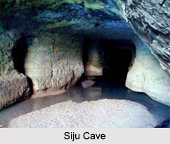
Siju Cave: Located on the cliff overhanging the right bank of the Simsang River in South Garo Hills district, the cave is locally known as "Dobakhol" or the "Cave of Bats". The cave consists of innumerable internal chambers and labyrinths.
Nokrek Peak: The highest point in the Garo Hills is Nokrek Peak with elevation of 1412 m; this is the place good for adventure trekking tours. The Nokrek National Park has been established at Nokrek and it abounds in various wildlife including herds of wild elephants, rare varieties of birds and pheasants, beside rare orchids.
 Siju Bird Sanctuary: Just across the Siju Cave on the other side of Simsang river in the South Garo Hills; where you can spot many rare and protected wild birds-during winter. Some migrating birds have been visiting this places, which will be an added attraction to wildlife lovers.
Imilchang Dare: This waterfall is located in South Garo Hills. The deep, wide pool at the bottom of the fall with its wide and expansive surroundings makes it an exciting swimming pool.
Balpakram: A National Wildlife Park, located in South Garo Hills and 167 km from Tura. It is home to the rare Red Panda, the Indian bison and the stag like Serow.
Sisobibra: Sisobibra is a place of historical importance where the Garos fought their last battle against the British under the command of Pa Togan Nengminja.
Bhaitbari: Bhaitbari is a small village of West Garo Hills district. The site is renowned for the archaeological finds having been uncovered after protracted `excavations` on the area.
Chibragre: The traditional hanging bamboo cane bridge suspended over the Ganol River from bank to bank lures many picnickers to try this swinging bridge.
Rongbang Dare: Clustered on either side by vast evergreen hills of Bamboo, the falls itself appears to be on the sway, leaving the viewer with memories of ecstatic joy.
Rongdong Falls: Just above the famous Siju Cave in the midst of green thick jungle one can see a beautiful waterfall cascading down.


