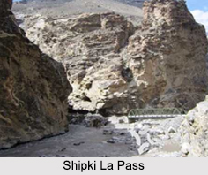
 Shipki La is a mountain pass with 3930 meters of elevation. It is also the border post between India and China. Indian portion of this pass comes under Kinnaur region of Himachal Pradesh and China occupies the pass in Ngari Prefecture in Tibet. River Sutlej, also called Langqen Zangbo in Tibet, enters India near this pass. Shipki La pass is one of the border posts of India for trade with China along with Nathu La pass in Sikkim and Lipulekh in Uttarakhand. Shipki La pass is located near the Khab village of Himachal Pradesh. The road at the Shipki La pass is an offshoot of the ancient Silk Road. Currently, the road is mainly used for local trade of small scale across the border. The opening of the border at the Shipki La pass is considered to be potential enough to increase trade on the both sides of the border.
Visiting Information to Shipki La Pass
There is no way to take permit to reach the pass directly without any special cause. One can go up to Puh or Nako via Spiti circuit to go close to the pass.
This article is a stub. You can enrich by adding more information to it. Send your Write Up to content@indianetzone.com


