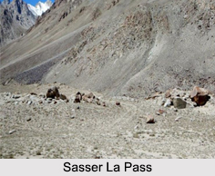
 Sasser Pass is high mountain pass located on the route from Leh in Ladakh to Yarkand in the Tarim Basin. This mountain pass with an elevation of 5411 meters leads from the head of the Nubra Valley into the upper Shyok valley to Karakoram Pass. Sasser Pass is also known as Saser Pass or Saser La pass. Saser Pass is located at a distance of 37 km southeast of the Siachen Glacier area that the 1972 Simla Agreement between India and Pakistan failed to define clearly. Earlier this place was too icy for the Bactrian camels, which were the usual pack of animals to the north of the Saser Pass.
Visiting Information on Sasser Pass
Sasser Pass can be reached via Leh. Nearest railway station to Leh would be Jammu Tawi railway station. Nearest airport would be Leh Airport.
This article is a stub. You can enrich by adding more information to it. Send your Write Up to content@indianetzone.com


