
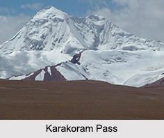
 Karakoram Pass is a mountain pass between India and China. It is located at an elevation of 5,540 meters above sea level and is the part of the Karakoram Range. The Karakoram Pass is also known as the silk route of India. It is the highest pass on the ancient caravan route between Leh in Ladakh and Yarkand in the Tarim Valley. The word "Karakoram" literally means "Black Gravel" in Turkic. Karakoram Pass is reckoned to be a potential tri-point of India, Pakistan and China. The pass once rendered excellent trade facility between India and China.
History of Karakoram Pass
The towering altitude and deficiency of food grains were the principal causes for the losses of numerous pack animals. The course through the pass was disreputable for the trace of bones sprinkled adjacent to the itinerary. There is virtually no presence of flora on the entry routes to the pass. The southern segment of the pass is more barren than the north. Traversing the lower Suget Pass is easier.
Route to Karakoram Pass
Karakoram Pass is in a saddle between two mountains. The width of the pass is approximately 45 meters (148 ft). There is no vegetation or icecap and it is generally free of snow due to the winds. There are low temperatures, recurrently powerful breezes, snowstorms are a common feature, and the towering altitude has an outcome. In spite of all these factors, the Karakoram Pass was considered a relatively easy pass due to the stable upward slope on both sides. There was deficiency of summer frost and snow for the maximum portion of the year. Therefore, the pass remained open for the maximum part of the year. However, there is no passable path over the pass, and the pass at the moment is kept shut to all types of traffic movements.
Geopolitical Issues of Karakoram Pass
The Karakoram pass falls on the boundary of Indian state of Jammu and Kashmir and China. It also plays a major geographic role in the dispute between Pakistan and India over control of the Siachen Glacier area immediately to the west of the pass. This situation arose from the Simla Agreement, signed in 1972 between India and Pakistan, when the treaty failed to specify the last 100 km (60 mi) or so of the cease-fire line from the end of the Line of Control to the border with China.
A probable India-China-Pakistan tripoint at Karakoram Pass is mentioned in a border pact between Pakistan and China in 1963. This was in relation to the Trans-Karakoram Tract; however India was not aware of that accord or any tripoint contract. The presently existing tripoint is approximately 100 km west to the pass at Indira Col in the Siachen Muztagh. This is the spot where the Actual Ground Position Line between Pakistani and Indian Army touches the boundary with China.









