 Pensila Pass is a mountain pass in the Ladakh region of Jammu and Kashmir. It is known as the "Gateway to Zanskar" and is also the gateway to Padam, the headquarters of Zanskar sub-division of Kargil district. This mountain pass connects the Suru valley to the Zanskar valley and also acts as a watershed destination for the Suru River. This pass is essentially the beginning of Ladakh on the Srinagar route. Pensila Pass in Zanskar Valley is the highest point on Kargil-Padam Road. This region is famous for plethora of medicinal plants as well as water springs with green water. This pass is a nature lover"s delight as one can spot brown bears and Marmots here.
Location of Pensila Pass
Pensila Pass is situated at an elevation of 4,400 m (14,436 ft) above sea level and connects the Suru Valley region to the Zanskar Valley region. The summit at this end of the Suru Valley, the only peak which can be seen, is 7,012 m (23,005 ft) high, while the mountain to the north is 6,873 m (22,549 ft).
Statso/ Langsto is a twin water body as lake at the point which gets discharge of melting snow around Drang Drung Glacier and Panzella glacier originates from Suru River. To the west of Pensila watershed flows the Suru River, an important tributary of the Indus which meets at Kargil. The Drang Drung Glacier to the eastern flank of Pensila Pass is the source of Stod or Doda River which flows into the Padam Valley, and joins with Tsarap Chu to form the mighty Zanskar River.
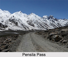
Route to Pensila Pass
Pensila pass is about 25 km from Rangdum Monastery. The pass is traversed by a metalled road. The descent from the Pensila into the Stod Valley is steeper than the climb up from Rangdum Gompa, but not too difficult. The road winds about with many hairpin turns, which can be cut across on foot, to the river below. Avalanches and heavy snowfalls can sometimes block some sections of the road and can be extremely dangerous due to frequent patches of ice. The Pensila Pass remains open between May and October.


