 People in Kargil are of diverse Dard and Tibetan descent. The inhabitants of Kargil were adherents of Tibetan Buddhism until the 14th-15th centuries when Muslim missionaries began to proselytise to the local people.
Location of Kargil
It is situated 60 km and 204 km from Drass and Srinagar to the west respectively, 234 km from Leh to the east, 240 km from Padum to the southeast and 1,047 km to Delhi in the south. This town has an average elevation of 2,676 metres (8,780 feet), and is situated along the banks of the Suru River. Like other areas in the Himalayas, Kargil has a temperate climate. Summers are hot with cool nights, while winters are long and chilly with temperatures often dropping from 48 degree C to 32 degree C (-54 degree F).
Geography of Kargil
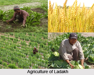
The architecture of older mosques in Kargil is an amalgamation of Tibetan and Iranian styles, while the newer mosques architectural styles have a tendency to follow those of modern Iranian and Arabic styles. Kargil town lies in the lower Suru basin. Two other rivers that meet here are Drass and Wakha Chu. All around there are thriving green fields of barley and wheat, vegetable beds and rows of poplars and willows. Kargil is well-known for its apricots and mulberries.
History of Kargil
 The name Kargil is derived from two words Khar and rKil. Khar means castle and rKil means center thus a place between castles as the place lay between many kingdoms. In the views of many critics, the word Kargil has been derived from the words Gar and Khil. Gar in local language mean "Any where" and Khil means a central place where people could stay. This has the support of the fact that the place is equidistant from Srinagar, Skardo, Leh and Padum with around 200 Kms. With the passage of time Khar rKil or Gar Khil came to be known as Kargil.
Gasho Tha Tha Khan is said to be the first renowned crusader who established a dynasty in the area. Tha Tha Khan was a scion of the royal family of Gilgit who captured Kargil in early 8th century. His dynasty ruled the Sod area of Kargil in early period and later permanently settled in Shakar Chiktan area where the dynasty is still in existence. Kacho"s of Kargil are believed to be the off-shoots of Tha Tha Khan. Purik Sulatan believed to be a renowned builder of Kargil who established his domain in Suru area and ruled from Karchay Khar near Sankoo. Kunchok Sherabtan of Fokar, Kalon of Mulback and many Kachos, Sultans and Maqpons of Sod, Pashkum, Wakha, Chiktan, Karchey ruled the area of Kargil and expanded their principalities to be merged with the State of Jammu and Kashmir.
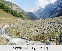
Islam came to Kargil in 15th century. Mir Shams-ud-Din Iraqi, a scholar of Shia school of central Asia visited Baltistan and Kargil with his missionaries to preach Islam. The chief of Baltistan embraced Islam first and it was later followed by the Chiefs of Kargil. Kargil became a separate district in the Ladakh region during the year 1979 when it was bifurcated from the erstwhile Leh district. Many monuments of the early Buddhist era dot the landscape and are accessible from the village. Perched atop a rocky cliff, the Mulbekh Gompa (monastery) dominates the valley. Like all monasteries it is adorned by frescoes and statues. Shergole is a small village right of the Wakha brook on the Kargil-Leh road. Visible from afar as a white speck against the brown granite, the monastery here literally hangs out of a cliff. The hilly land Kargil, has its own appeal to the travellers for the near to heaven surroundings with the snowy vicinity that takes the minds to a distant place where the beauty of Himalayas catches the eyes of the beholder.
Demography of Kargil
As per 2011 census Kargil district has a population of 143,388. Kargil district has a population density of 10 inhabitants per square kilometre (26/sq mi). The population growth rate over the decade 2001-2011 was 20.18%. Kargil has a sex ratio of 775 females per every 1000 males, and a literacy rate of 74.49%, slightly more than the national average of 74.04%.
People in Kargil are of mixed Dard and Tibetan descent and majority are Baltis. These inhabitants of Kargil were adherents of Tibetan Buddhism until the 14th-15th centuries when Muslim missionaries began to proselytise to the local people. Today, 90% of Kargil`s population are Shia Muslim, 5% Sunni and 5% Tibetan Buddhist.
Tourism in Kargil
There are several places of tourist interest in Kargil town. Situated 45 km east of Kargil on the road to Leh, Mulbekh (3230m) is a typical Buddhist village. There are several monasteries that can catch the glimpse of many visitors like Sani Monastery, Rangdum Monastery, Zongkhul Monastery, Karsha Monastery, Stongday Monastery, Phugthal Monastery, Zangla and Shargole Monastery are notable ones. Apart from these the natural beauty of the snow caped hills and the wildlife at Kargil are other major attractions. Kargil is home to many endangered wildlife species like snow leopard, Tibetan wolf, Himalayan brown bear, Asiatic ibex, Ladakh urial, musk deer (, pikas, marmots and hares.
Visiting Information in Kargil
National Highway 1D, connecting Srinagar to Leh, cuts through Kargil. This highway is typically open for traffic only from June to mid-November due to heavy snowfall at the Zoji La, but in recent years it has been opened before June. There is a partially paved road where the first 40 kilometres (25 mi) or so is leading from Kargil south to Zanskar. Total distance to Zanskar is nearly 220 km (140 mi), which is again open only from June to September. The region has recently been opening to tourists by the Central Government.