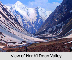
 Har Ki Doon Valley is a hanging valley with the shape of a cradle situated in the Garhwal Himalayas in the Indian state of Uttarakhand. This valley is encompassed by peaks and alpine vegetation. It is connected to Baspa Valley by the Borasu Pass. Har Ki Doon Valley has an elevation of 3566 meters above mean sea level and it is located at a distance of 26 km from Taluka. Har Ki Doon Valley is considered to be one of the best places for trekking. The 5-day trekking to the Har Ki Doon Valley starts from Taluka village and passes through Gangar, Osla and Seema. This valley is also known as "The Valley of Gods".
This article is a stub. You can enrich by adding more information to it. Send your Write Up to content@indianetzone.com


