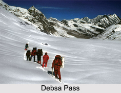
 Debsa Pass is a mountain pass in Himalayan Mountain Ranges, which is situated between the districts of Kullu and Spiti of Himachal Pradesh. The pass is 5360m in height. Joydeep Sircar with his teams discovered the pass after approaching through the Parbati River valley in Kullu.
Expeditions to Reach Debsa Pass
First they made an attempt in the year 1992, which was futile. Later in 1993 finally the pass was located and reached successfully. But the team did not cross the pass on the Spiti portion for the wrong impression of being arrested for not having Inner Line Permits for Spiti. Then in 1995, the team again planned to approach Spiti but due to heavy autumn floods in the upper valley of the Beas River and other portions of Himachal Pradesh, they had to take the Parbati route again to reach Debsa Pass. This time they crossed the pass on 21st September and completed the route from Manikaran to Kaja.
This article is a stub. You can enrich by adding more information to it. Send your Write Up to content@indianetzone.com


