 The state of Himachal Pradesh is located in the northern part of India. This state has convoluted topography of interlocking mountain chains, snowy peaks and plunging river valleys. Such a geographical terrain has beautified Himachal Pradesh. It also provides opportunity for trekking, rafting, paragliding and skiing, thereby drawing tourists to this state. Lakes of Himachal Pradesh are no exception in this regard. They also have the potential to catch the attention of tourists visiting this state.
Renuka Lake
Renuka Lake is located at an altitude of about 672 m above the sea level in the district of Sirmaur. Its name is based on the name of goddess Renuka. It has a circumference of about 3214 m. This lake is threatened by silt deposition and accumulation of waste of construction material. It has the distinction of being the largest lake of Himachal Pradesh.
Kareri Lake
Kareri Lake is situated south of the Dhauladhar range in the district of Kangra. Characteristically, this lake is a high altitude, shallow and fresh water lake. Its name is based on the name of a nearby gaddi village of Kareri. Mankiani Peak is regarded as its primary inflow and Nyund Stream is known to be its primary outflow.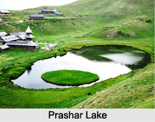
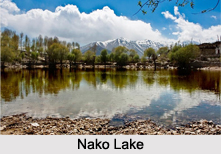
Nako Lake
Pooh sub-division of the Kinnaur district is beautified by Nako Lake. This lake is situated at an elevation of about 3,662 m (12,010 ft) and therefore is known as a high altitude lake. Willow and poplar trees and four Buddhist temples lend a picturesque setting to this lake.
Rewalsar Lake
Rewalsar Lake is located on a mountain spur, about 22.5 km south-west from Mandi district. It is also called the "Tso Pema Lotus Lake" by the Tibetan Buddhists. This lake is situated at an elevation of about 1,360 m above sea level and its shoreline is about 735 m. It is a square-shaped mid-altitude lake and is also held sacred. Being a holy lake, fishing is prohibited here.
Dehnasar Lake
Dehnasar Lake is situated in Barot Valley in the district of Kangra. Characteristically, it is a high-altitude freshwater lake. Its catchment area is formed by Lumbadug Valley. This lake is situated at an elevation of about 4,280 meters (14,040 ft) above mean sea level.
Other Lakes in Himachal Pradesh
Some of the other Lakes in Himachal Pradesh are Dhankar Lake, Macchial Lake, Prashar Lake, Chandra Tal, Ghadhasaru Lake and Mahakali Lake.


