About Mangalore
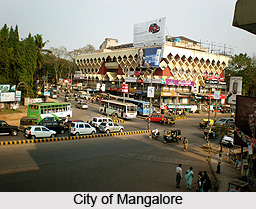
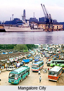
 Mangalore is a city of Karnataka and also the capital of Dakshina Kannada. Mangalore is situated at 12.870 N and 74.880 E of Karnataka. The main attraction of Mangalore is its beaches, temples and industries. This chief port city of Karnataka is located on the west coast of the country on the Arabian Sea and on the east of the city is the Western Ghats. Mangalore is also the administrative headquarters of Dakshina Kannada. The port of Mangalore handles India`s 75% coffee exports and the bulk of its cashew nuts. Mangalore is also the 9th largest cargo handling port of India. As per the World Gazetteer, the estimated population of Mangalore in 2008 is 431,976, which makes it the 101st most populous city in India. The same census depicts that the 50% of the population is male and the 50% are female, which is a nice balance of the genders.
The Mangalore city was named after the local Hindu deity Mangaladevi. The earliest reference of the Mangalore city`s name was made by the Pandya king Chettian.
The cosmopolitan nature of Mangalore is hundreds of years old. The languages spoken in the Mangalore are mainly Tulu, Konkani, Kannada and Beary apart from Hindi, Urdu and English. A large group of people of the city follow Hinduism. There is also a sizeable group of people, who follow Jainism.
The landscape of the city is very beautiful with the coconut palms in the rolling hills and streams flowing into the sea. The tiled-roof buildings of the city are made with the popular Mangalore tiles made from the local hard red clay and walled with laterite blocks. The older houses are mainly made of wooden walls.
Mangalore is the trading centre for the state. Even the 1st century travelers knew about the city. The history of the city is hardly known but it is known that the city was once ruled by a tribe named `Alupas`. But Mangalore has been declared as the earthquake prone zone by the Government.
 The visitors` attraction point is the Kerala style Kadri Temple of Mangalore. This temple is designed in modern layout and it has a bronze statue of Lokeshwara, which is famous for being the best bronze of India.
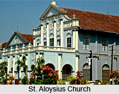
The St Aloysius College chapel of Mangalore is well known for its mural covered walls and ceiling. These were painted by Reverend Antonio Moscheni at the beginning of the 20th century. Rosario Cathedral is another site to visit in Mangalore. It is a large, plain white washed edifice built in 1910. It is said that the dome was modelled on St Peter`s Basilica in Rome.
Mangalore got its name from the temple of `Mangaladevi`, which is situated at a short distance of the cathedral. The three silver doorways of the temple are the most beautiful part of the temple.
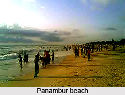
The Mangalore city is surrounded by numerous beaches like Mukka beach, Panambur beach, Tannirbavi beach, KREC beach and Someshwara beach. These are surrounded by coconut trees, palm trees, Ashoka trees along with others. This city is yet very much covered with greenery compared to the other cities of the country. These green beauty of the city can be enjoyed in the Pilikula Nisargadhama, Kadri Park, Tagore Park and in Corporate bank Park.
There are lots of malls and shopping complexes in Mangalore. The "Empire Mall" of Mangalore has the Nilgiris supermarket, Coffee Day, Pizza Corner, Dollar store and few other retail chains. The "Bharath Mall" has Adlabs 4 screen Multiplex, Big Bazaar,Food Bazaar, PlanetM, Pizza Hut, Pantaloons, Coffee Day, Subway, Adidas, Reebok, Provogue, Planet Sports, Swawroski, Lewis are few among many others. Spencers, McDonalds, Westside, Reliance Fresh, Landmark, Shoppers Stop have also booked their spaces. This mall will also feature a 6-screen multiplex called `Fun Cinemas`.
The climate of Mangalore is of tropical nature. The average temperature of the city ranges between 270 C to 340 C, which is almost same in both summer and winter seasons. It is very comfortable for the tourists but the humidity is a problem, which reaches up to 78%. The 90% rainfall of the Mangalore city is received within the months of May to October, whereas it remains extremely dry from the month of December to March. The best season to visit the Mangalore city is from September to March month because during this period the humidity and temperature remain lowest.
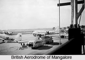
 Mangalore is one of the pleasant and beautiful cities of India. The city is well connected with other districts and many other states of the country. Various transportation means like air, road and rail are available. Mangalore has an international airport located at Bajpe, which is about 30km away from the city. Now, there are daily flights are available for Mumbai, Bangalore, Chennai, Goa, Kochi and Calicut. Whereas, for the international visitors, there are weekly and bi-weekly flights are available for Dubai, Abu Dhabi, Muscat (Oman), Doha (Qatar) and Bahrain. The flights operating from Mangalore comprises Alliance Air, Jet Airways, Kingfisher Airlines, Air Deccan and Air India Express.
There are two big railway stations in Mangalore. The Mangalore station is at Hampankatta, in the heart of the city, which is a terminus. Another station is Kankanady, which is situated about 5 to 10 km from the city. This is on the Konkan railway track and connects Mangalore to Goa and Mumbai in the north and to Kerala in the south. The visitors coming from North Mangalore get down at Surathkal to avoid the traffic between Surathkal and Mangalore. It is a suburb of Mangalore and about 20 kilometers away from the city. From there, bus is available for Mangalore.
The visitors from the nearby states can opt for the bus as the medium of transport. There are two bus stands in Mangalore for long distance services. One is at Bejai, which is the state run KSRTC bus-stand and it is located to the North of the city. From here buses go to Mumbai, Bangalore, Mysore, Goa, Hubli-Dharwad and many other areas within and outside Karnataka. The second bus stand is behind the Town Hall and it is commonly known as the `State Bank` stand.
Another bus stand is also available in front of Milagres Church, where most of the tour and bus operators have their offices. Here buses of semi-deluxe, sleeper and Volvo types to various destinations viz. Mumbai, Bangalore, Goa, Thrissur, and Hubli-Dharwad etc can be found.
 To look around the Mangalore city, the visitors can opt for buses, cabs and auto rickshaws. There are private bus services like Padmambika Bus Co. Ltd, which connect to all other minor centres surrounding Mangalore. Most of them leave from the `State Bank` stand.
The ambassador cabs/Indicas are also available to move around the Mangalore city. Prepaid cabs are also available from the airport to the city, which has a fixed fare of Rs 350 to 400. One can even rent cars in Mangalore to visit the city. So, Mangalore is one of the cities, which is targeted by the tourists to enjoy a holiday.
For complete business listing of Mangalore visit Mangalore Yellowpages
History of Mangalore
 History of Mangalore deals with the mythological stories of Indian epics, ancient kingdoms of South India, medieval kingdoms of the Muslim Dynasty and the rulers of European colonial eras.
Mangalore is locally known as Mangaluru. The name "Mangalore" has been mentioned in many ancient works of Hindu mythological and political history. The name of this town Mangalore appeared first in maps as early as the 1652 Sanson Map of India.
Early History of Mangalore
Early history of Mangalore deals with the early Indian mythology. In the Indian epic, Ramayana, Lord Rama ruled over the region, which is now called as Mangalore or Mangaluru. While on the contrary, in another Indian epic of Mahabharata, Sahadeva, the youngest of the Pandavas, governed the area. Arjuna, the hero of Mahabharata, also visited the area when he travelled from Gokarna to Adoor, a village near Kasargod district. The region of historical importance, Mangalore is highlighted by the many references to the city by foreign travellers. Cosmas Indicopleustes, a Greek monk, referred to the port of Mangalore as Mangarouth. Pliny the Elder, a Roman historian, made references to a place called Nitrias. The Greek historian Ptolemy referred Mangalore as Nitra in the early times. The views of Ptolemy and Pliny the Elder were probably made to the Netravati River, the major lifeline of Karnataka which flows through Mangalore. Ptolemy is also referred to the city as Maganoor in some of his works. In the third century BC, Mangalore was governed by Maurya Empire. At that time Mangalore was known as Sathia (Shantika). From second century BC to sixth century BC, the Kadamba dynasty ruled over the region.
 Medieval History of Mangalore
Medieval History of Mangalore begins with the glorious regime of Kadambi Dynasty to the Chalukya Dynasty. Later from 567 to 1325 AD, the town was ruled by the native Alupa rulers. The Alupa rulers ruled over the region as feudatories of major regional dynasties like the Chalukya Dynasty of Badami, Rashtrakuta Dynasty, Chalukya Dynasty of Kalyani, and Hoysala Dynasty of Karnataka.
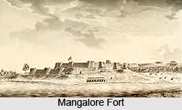
Mangalapura or Mangalore was the capital of the Alupa dynasty until the 14th century. The city of Mangalore became an important trading zone for Persian merchants. The city, Mangalore was visited by Adenese merchant Abraham Ben Yiju. The Moroccan traveller Ibn Battuta, who had visited the town in 1342, referred to it as Manjarun, and stated that the town was situated on a large estuary. By 1345, the Vijayanagara rulers brought the region under their control. Later, the Jain Kings ruled the town as feudatories of the Vijayanagar Empire, and brought the town firmly under an efficient and centralised administration. In the year 1448, Abdul Razak, the Persian ambassador of Sultan Shah Rukh of Samarkand, visited Mangalore, and was amazed at a glorious temple he saw in the city, en route to Vijayanagara. From the time of Vijaynagara rule, Mangalore became the hotspot for the religious people. Later after the downfall of Mughal Empire in India, the regional power came into existence and began to rule Mangalore. European influence in Mangalore can be traced back to 1498, when the Portuguese explorer Vasco da Gama landed at St Mary`s Island near Mangalore. Later the rule of Haider Ali and his son Tipu Sultan named Mangalore as the City of revolt against British East India Company.
Modern History of Mangalore
After the downfall of Mughal Empire and the regional empires like, the empire of Haider Ali and Tipu Sultan came into existence and the French East India Company gained prominence rather than British East India Company.
 After tumultuous battle with Haider Ali and Tipu Sultan, British East India Company came to power of Mangalore or Mangaluru. The city was largely peaceful during British rule, with urban and infrastructural developments affected during the period. Mangalore flourished in education and in industry, becoming a commercial centre for trade. The opening of the Lutheran German Basel Mission in 1834 brought many cotton weaving and tile manufacturers to the city.
After the independence of India, by the States Reorganisation Act (1956), Mangalore, which was the part of the Madras Presidency, was included into the authority of the newly created Mysore, which was the Princely State of Mysore during the rule of British East India Company. Mangalore is a major city of Karnataka, providing the state with access to the coastline of Arabian Sea.
Geography of Mangalore
 Geography of Mangalore deals with the landforms, rivers and the topography of Dakshina Kannada district of Karnataka.
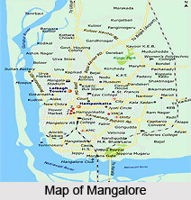
Mangalore, the city of trade and commerce, is located at 12.87 degree North to 74.88 degree East in the Dakshina Kannada district of Karnataka.
Mangalore has an average elevation of 22 metres above mean sea level. It is the administrative headquarters of the Dakshina Kannada district, the largest urban coastal center of Karnataka, and the fourth largest city in the state.
Mangalore, the place of forts, palaces and the temples is situated on the west coast of India, and is bounded by the Arabian Sea to its west and the Western Ghats to its east. Mangalore city, as a municipal entity, spans an area of 200 square kilometres. Mangalore experiences moderate to gusty winds during day time and gentle winds at night.
Climate of Mangalore
Mangalore has a tropical monsoon climate and is under the direct influence of the Arabian Sea branch of the southwest monsoon. Mangalore receives about 95 per cent of its total annual rainfall within a period of about six months from May to October, while remaining extremely dry from December to March. The annual precipitation in Mangalore is 3,479 millimetres. The humidity is approximately 75 per cent on average, and peaks during May, June and July. The maximum average humidity is 93 per cent in July and average minimum humidity is 56 per cent in January.
 From December to February, the temperatures during the day time ranges below 30 degree Celsius and drop to about 19 degree Celsius at night. This season is soon followed by a hot summer, from March to May, when temperatures rise as high as 38 degree Celsius. The summer gives way to the monsoon season, when the city experiences more precipitation than most urban centres in India, due to the Western Ghats. The rainfall is about 4,000 millimetres. The rains subsided in September, with the occasional rainfall in October.
Topography of Mangalore
The topography of the city of Mangalore is plain up to 30 km inside the coast and changes to undulating hilly terrain sharply towards the east in Western Ghats. There are four hilly regions with natural valleys within the city. The geology of the city is characterised by hard laterite in hilly tracts and sandy soil along the seashore. Mangalore is defined as the earthquake prone zone.
Rivers of Mangalore
Mangalore lies on the backwaters of the Netravati River and Gurupura River. These rivers effectively encircle the city, with the Gurupura flowing around the north and the Netravti flowing around the south of the city. The rivers form an estuary at the south-western region of the city and subsequently flow into the Arabian Sea. Mangalore is often used as a staging point for traffic along the Malabar Coast. The coastline of the city is dotted with several beaches, such as Mukka, Panambur, Tannirbavi, Suratkal, and Someshwara.
Demography of Mangalore
 Demography of Mangalore or Mangaluru is directly related with its culture and heritages. Mangalore, the city of Mughal and Hindu cultural combination has a population of 484,785. It was recorded according to the 2011 census of India. The sex ratio of Mangalore city, done by the population census is 1014 per 1000 males. The child sex ratio of girls is 930 per 1000 boys.
Urban Population of Mangalore
The urban area of Mangalore has a population of 619,664, while the Mangalore city, with both rural and urban areas, has a population of 484,785. The number of males in urban areas was 240,651. It constitutes 50 per cent of the population, while the numbers of females were 244,134. The decadal growth rate of Mangalore was 45.90.
Literacy Rate of Mangalore
The male literacy rate of Mangalore was 96.49 percent, while female literacy was 91.63 percent. About 8.5 per cent population in Mangalore was under six years of age. The literacy rate of Mangalore is 94.03 per cent, which is significantly higher than the national average of 59.5 percent. The birth rate was 13.7 per cent, while death rate and infant mortality rate were at 3.7 per cent and 1.2 per cent respectively. The Mangalore urban area had 32 recognised slums, and nearly 22,000 migrant labourers lived in slums within the city limits.
Languages of Mangalore
The four main languages in Mangalore are Tulu language, Konkani language, Kannada language, and Beary basse language. The Tulu language is the mother tongue of the majority of Mangalore population. Malayalam language, Hindi language, Urdu language and English language are also spoken in the city.
Religion in Mangalore
Hinduism is the largest religion in Mangalore, with Devadiga, Mogaveeras, Billavas, Ganigas, Bunts, Kota Brahmins, Shivalli Brahmins, Havyaka Brahmins, Sthanika Brahmins, Goud Saraswat Brahmins (GSBs), Chitpavan Brahmins are the major communities in Hindus. Christians form a sizeable section of Mangalorean society. Mangalore has one of the uppermost proportions of Muslim community as compared to other cities in Karnataka. Most of the Muslims in Mangalore are Bearys, who speak a dialect of Malayalam called Beary basse dialect of Mangalorean regional language.
Culture of Mangalore
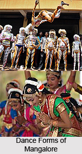 Culture of Mangalore deals with the South Indian dance-drama, dances theatres, and last but not the least is cuisine which are globally famous. The most famous dance-drama in Mangalore and its adjacent area is Yakshagana. Yakshagana is a theatre form that combines dance, music, dialogue, costume, make-up, and stage techniques with a unique style and form. This theatre style resembles the Western opera. Yakshagana is traditionally presented from dusk to dawn.
Dances of Mangalore
The Yakshagana is a night-long dance and drama performance, is held in Mangalore. while Pilivesha, which is known as the tiger dance, a folk dance unique to the city, is performed during Dussehara and Janmashtami.
Karadi Vesha, the bear dance is another well known dance performed during Dasara. Paddanas, the ballad-like epics passed on through generations by word of mouth are sung by a community of impersonators in Tulu and are usually accompanied by the rhythmic drum beats. The Beary dance is unique dance showcasing the folk traditions. Beary Dances are reflected in such folk songs as Kolkai, which is sung during Kolata, a valour folk-dance during which sticks used as properties, Unjal pat, a traditional lullaby, Moilanji pat, and Oppune pat, sung at weddings. The Evkaristik Purshanva is an annual Catholic religious procession led on the first Sunday of each New Year.
Festivals of Mangalore
 Most of the popular Indian festivals are celebrated in the city, the most important being Dussehra, Diwali, Christmas, Easter, Eid-ul-fater, and Ganesh Chaturthi. Kodial Theru, also known as Mangaluru Rathotsava (Mangalore Car Festival) is a festival unique to the Goud Saraswat Brahmin community, and is celebrated at the Sri Venkatramana Temple. The unique festivals of Mangalorean Catholics community include Monti Fest or Mother Mary`s feast, which celebrates the Nativity feast and the blessing of new harvests. Aati, a festival worshiping Kalanja, a patron spirit of the city, occurs during the Aashaadha month of Hindu calendar. The festivals in Mangalore such as Karavali Utsav and Kudlostava are highlighted by national and state-level performances in dance, drama and music. Bhuta Kola is usually performed by the Tuluva community at night. Nagaradhane is performed in the city in praise of the serpent king, who is said to be the protector of all snakes. Hindu Kori Katta, a religious and spiritual cockfight, is held at the Hindu temples of Mangalore and also allowed if organised as part of religious or cultural events.
Cuisine of Mangalore
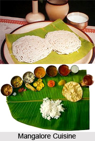
Cuisine of Mangalore is largely influenced by the South Indian cuisine. There are several cuisines being unique to the diverse communities of the city. The coconut and curry leaves are common ingredients to most Mangalorean Curry. The people of Mangalore use ginger, garlic and chilli for cooking. The vegetarian cuisine of Mangalore, also known as Udupi cuisine, is known and liked throughout the state and region.
Temples in Mangalore
 This port city, whose original name was Mangalapura, has been mentioned in 7th century inscriptions. The city, known for its scenic beauty, is situated at the confluence of Netravati and Gurpur rivers. The presence of the religious places provides an aesthetic charm to Mangalore. The city is linked by flights from Bangalore, Mumbai and other important cities. It is well connected by train and bus services as well.
Mangaladevi Temple is situated 3 kilometers away from Mangalore city. The Shakti Temple, which gives Mangalore its name, was originally built by the Ballalas and rebuilt in 968 AD by Kundavarma II, an Alupa ruler. The present temple is said to have been constructed by one of the Nayak kings.
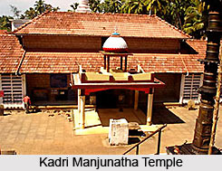
Sri Manjunatha Temple is situated on Kadri hills and is dedicated to Lord Manjunatha. It is located 5 kilometers away from the city.
River Nandini flows round the beautiful shrine in Katil. The temple, located 30 kilometers away, is dedicated to Devi Durga Parameswari. The river is considered the daughter of the Divine Cow Kamadhenu. She was cursed by Rishi Japali for refusing to come to Bhooloka with him to relieve it of a drought prevailing at that time.
Several legends are associated with this temple. One of them concerns Devi Parashakti. It is said that she came here to annihilate Arunasura. When he was enamored of the beauty of the Goddess, She took the form of a bee and killed the asura in the midst of the river.
According to Hinduism Devi Durga is a Swayambu Lingam. An image of the Devi in sitting posture holding Shankha and Chakra is also installed. Devotees throng the temple on Fridays and during Navaratri festival.
 There are several temples of Mangalore district set on the panorama of palm-fringed beaches, luxuriant green fields and enchanting forests. The temples of Mangalore district are sheltered by the soaring Western Ghats on the east and the mighty Arabian Sea roaring along its western shores.
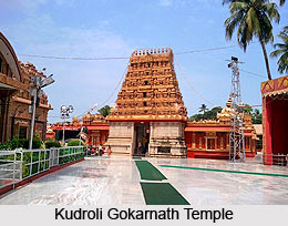
Kudroli Gokarnanatha Temple is one of the important temples of Mangalore district that is situated in the city of Mangalore. This beautiful temple is the abode of Lord Gokarnatha, another name for Lord Shiva. Compared to the other temples of Mangalore district, this temple was built pretty recently but reflects the traditional pattern of architecture. Shri Narayana Guru, the great saint and philosopher, who had visited Mangalore in the year 1912, uttered his wish that the Billavas (a caste of people) should build a temple for Lord Shiva in the city. The Navarathri Utsava is a famous annual festival of this temple.
Kadri Manjunatha Temple is also one of the beautiful temples of Mangalore district, situated on the hills of Kadri. There is however route number 44h, 60, 61, which halt just about half a kilometer away from the temple. The temple was built during the 10th or 11th century. Later, it was converted to a complete stone structure during the 14th century. The idol of Lord Manjunathaswamy of the temple is called as oldest among the South Indian Temples.
Mangaladevi Temple is possible one of the most recognised temples of Mangalore district built by the Ballal family of Attavar in memory of a Princess of Kerala. Various pujas and rituals are performed by Vedic brahmins regularly. During Navarathri (dussera) special pujas are performed in this temple on all the nine days. On the seventh day, Godess Mangaladevi is worshipped as Sharadamba and on the eight day the goddess is worshipped as Maarikamba.
Shree Parivara Panchalingeshwara Temple, Shree Shanmukha Subramanya Temple, Shree Sita Ramachandra Devasthana, Shree Vasuki Subrahmanya Temple, Shree Venkatramana Temple, Shri Adishakthi Brahmalinga are some of the main temples of Mangalore district. Majority of the population here following Hinduism ardently visits the temples of Mangalore district like Shri Durgadevi Temple, Shri Lakshmi Venkatesh Temple and Shri Mangaladevi Temple. The temples of Mangalore district have become popular tourist destinations over the year.
Tourism in Mangalore
 Tourism in Mangalore, Karnataka, is immensely refreshing for the variety of essence it offers. Referred as the gateway to Kartnataka, the city is very picturesque and exhibits the beauty of blue Arabian Sea and lofty hills of Western Ghats covered with lush greenery. The strategic location of this port city had allured the rules of various powers and most of them have left their imprints and relics in the city. An amalgam of diverse cultures can be witnessed in Mangalore which owes to its verve. Many religious refuges stand in the city, which appease the spiritual needs of different communities. Being a combination of diverse flavours, this beautiful city has invited a plethora of tourists from far of places over years.
Pilgrimage Tourism in Mangalore
Pilgrimage tourism in Mangalore is quite popular among the people belonging to all religions as the place provides diverse religious refuges. These gather a number of devotees and tourists from far off regions not only for their religious significance but also for exploring the architectural wonders and unique traditions prevailing in the city.
Kadri Manjunath Temple
Kadri Manjunath Temple is located at the foot of the highest hill of the city. The temple belongs to 11th century. It exhibits a square structure along with nine tanks. It houses the idol of Lokeshwara which is regarded as the best bronze statue of the country.
Mangaladevi Temple
Mangaladevi Temple is another temple of Mangalore. It was constructed by the Ballal family of Attavar as a tribute to a Princess of Kerala.
St. Aloysius Church
 St. Aloysius Church stands in the city of Mangalore as a religious refuge of Christians. The church walls showcase paintings of the Italian artist Antony Moshaini. It was constructed between the period of 1899 and 1900. The architectural grandeur of the church invites a number of tourists too and has often encountered comparison with the famous Sistine Chapel of Rome.
Ullal Dargah
Ullal Dargah is a prominent mosque of the city and is also the centre of the grand Uroos fair. It was structured in the year 1958. Uroos festival which is celebrated in the mosque once in five years allures devotees from far off regions across the country.
Dharamasthala
Dharamasthala is a temple village nestled along the bank of the Nethravathi River. It is located towards the east of Mangalore at a distance of 75 kilometres. The village is famed for a Shiva temple where the Lingam is worshipped.
Gorkarna
Gokarna is another pilgrimage destination near the city which is visited by a number of Hindu devotees. The village also serves as a tourist destination as it nurtures a number of beaches and temples.
Nature Tourism in Mangalore
Nature tourism in Mangalore is immensely pleasing owing to its plethora of beaches and places embraced by exquisite natural beauty. The port city exhibits a unique charm and is bestowed with some of the most beautiful landscapes.
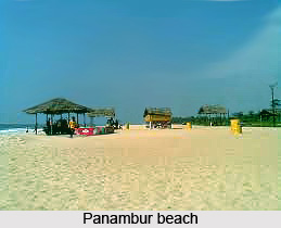
Mangalore Beach
Mangalore beach lies near the backwaters formed owing to the confluence of Netravathi and Gurupur Rivers. The beach has an enchanting natural beauty. It also hosts a special night long performance of Yakshagana which is worth witnessing. It is also the site for Kambala or Buffalo event.
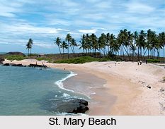
St. Mary Beach
 St. Mary beach is located at a distance of 58 kilometres from the city of Mangalore. The magnificent beach offers an invigorating time to the visitors. Crystallized basalt rocks are scattered over the beach which form another attraction. Due to the rocky terrain, the beach is not favourable for strolling and swimming.
Suratkal Beach
Suratkal beach is another popular beach, situated at a distance of 15 kilometres from the city. The beach hosts a temple along its shore which is dedicated to Sadashiva.
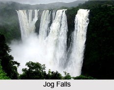
Jog Falls
Jog Falls is another natural charm located near Managlore. It is popular for being the second highest plunge waterfalls in the country after Nohkalikai Falls in Meghalaya.
Leisure Tourism in Mangalore
Leisure tourism in Mangalore provides an opportunity to explore many intrinsic aspects of the city and offers a refreshing time to the visitors. The history as well as the lifestyle of the city peeps out through these places.
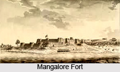
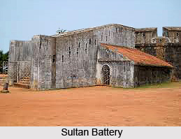
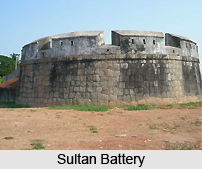
Sultan Battery
Sultan Battery is a historical monument located at a distance of 6 kilometres from the city of Mangalore. This black stone structure was constructed by Tipu Sultan for preventing the entry of warships to the Gurpur River. Presently it is in ruins and is often referred as Tipu`s well. The relics stands in a deserted place, however there is a watchtower which gives the impression that the monument was once a miniature fortress.
Light House Hill Garden
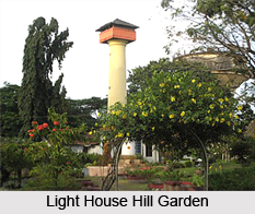 There is an ancient lighthouse in Mangalore which belongs to 18th century and was built by Hyder Ali. A beautiful garden is set near the lighthouse which offers panoramic view of the vast sea and the ships and boats sailing on it.
Seemanthi Bai Government Museum
Seemanthi Bai Government Museum is an excellent place for leisure tourism in Mangalore. It hosts a huge assortment of idols and artefacts of historical significance.
Kadri Park
Kadri Park is cherished by the children and adults alike. It shelters snakes and animal zoo, a wonderful garden and a toy train.
 Shri Yogishwar Mutt
Shri Yogishwar Mutt is known to be one of the prominent Jogi Mutts of the country. Kala Bhairava is its presiding deity who is a frightening form comprised of the features of Lord Shiva, Goddess Durga and Agni. The deity is greatly revered and worshipped by the Sadhus of the mutts.
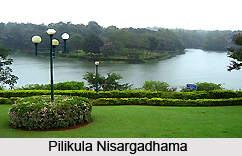
Pilikula Nisargadhama
Pilikula Nisargadhama is another tourist attraction of Mangalore which is known as a mystic spot where tigers roam freely. Spanning over an area of 350 acres, the name of the park refers to the pond of tigers. This integrated nature park is also popular as Pilikula Park and Golf Course. It is located over a hillock and comprises Pilikula Lake, Science Centre, Boating, Animal Park, Manasa Water Park and a Golf Course.
Light House Hill Garden
 The city also hosts a light house belonging to the 18th century which was constructed by Hyder Ali. Near the lighthouse, a garden has been set up which offers magnificent view of the sea along with sailing boats and ships. Mesmerizing views of sunsets can also be obtained from the garden, which has also been renovated to augment its beauty.
Kadri Hill Park
Kadri Hill Park is credited to be the largest park of the city which comprises an animal conservatory. It is under the administration of the Government Horticulture Department. Various faunal species can be seen in the animal conservatory. Other attractions of the park include a snake zoo, a toy train and a wonderful garden. Every year the Horticulture Department organizes flower show in the garden. The place serves as an enjoyable hangout spot.
Mahatma Gandhi Museum
Mahatma Gandhi Museum is another attraction of Mangalore city which hosts collection of anthropology, manuscripts, coins, art and sculpture. It was established in the year 1930. This educational museum also organizes informative lectures and film shows occasionally.
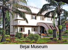
Bejai Museum
Bejai Museum stands at the heart of the city. It is also referred to as Seemanthi Bai Government Museum. The museum is well known for providing a link between the history of 16th century and the modern India. It hosts a huge collection of ancient as well as foreign coins.
Sultan Battery
Sultan Battery is an ancient monument structured in black stone standing in a deserted region. It was built by Tipu Sultan for preventing the warships from entering the Gurpur River. The monument is presently in ruins but its relics along with a watchtower and arrangements for mounting cannons all-round suggest that it was once a miniature fortress.
Sammilan Shetty`s Butterfly Park
 Sammilan Shetty`s Butterfly Park is located in Belvai village near Mangalore. It is an open air butterfly park which has been set up with the purpose of conserving the butterflies. It encompasses an area of 7.35 acres of land. It is the home to more than 100 species of butterflies including many endemic ones. A visit to the butterfly park dazzles the visitors with the vibrant and colourful butterflies.
New Mangalore Port
New Mangalore Port lies at a distance of 10 kilometres from the city and is credited as the ninth biggest port of India. Commodities like containerized cargo, cashew, coffee, granite stones, manganese, iron ore fines, Iron ore concentrates and pellets are mostly exported through the port. Prime products of import include liquid chemicals, phosphoric acid, liquid ammonia, finished fertilizers, timber logs, LPG, wood pulp, petroleum products and others.


