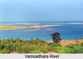
 Vamsadhara River is a significant east flowing river between Godavari and Mahanadi which meanders between north-eastern Andhra Pradesh and southern Odisha. It is also known as Bansadhara in the state of Odisha. The origin of the river lies in the border of Kalyansinghpur in Rayagada district and Thuamul Rampur in Kalahandi district of Odisha. The river flows for a length of 254 kilometres after which it joins the Bay of Bengal at Kalingapatnam in Andhra Pradesh. The catchment area of the river comprises an area of 10,830 square kilometres. Kalingapatnam and Mukhalingam, the famed tourist attractions of Srikakulam district are situated along the banks of Vamsadhara River.
Nomenclature of Vamsadhara River
The name of Vamsadhara River has been derived from the words `bansa` which means bamboo and `dhara` which means water flow. The river in fact originates from the forests covered with bamboo trees. Thus the river received the name of Bansadhara in Oriya which was transliterated as Vamsadhara in Telugu.
Features of Vamsadhara River
Vamsadhara river basin covers an area of 8015 square kilometres in the state of Odisha and 2815 square kilometres in Andhra Pradesh. The average annual rainfall received by the river basin is 1400 millimetres. The portion of the river basin in Rayagada district of Odisha primarily comprises hilly areas with tribal population.
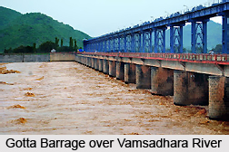 It has been estimated that around 115 thousand million cubic feet water from the river is available for use by the two states. However the states made an agreement to utilize the total available water in 50:50 ratio. Neredi barrage and Gotta barrage projects have been taken up by Andhra Pradesh for making use of their share of water. Odisha has however not involved in any new project and is diverting the water from the river to adjacent Rushikulya river basin by building Harabhangi reservoir near Adaba town. A peculiar feature of Vamsadhara River is that all the possible storage reservoirs are situated in the state of Odisha while the major portion of land to be irrigated lies in Andhra Pradesh.
Tributary of Vamsadhara River
One of the major tributaries of Vamsadhara River is Mahendratanaya which originates in Gajapati district of Odisha. It joins the main river in the state of Andhra Pradesh, upstream of Gotta barrage. For diverting the river for irrigation purpose, the construction of Regulapadu barrage has been started.
Vamsadhara Project
Vamsadhara River forms the prime river of Uttarandhra region which comprises three north coastal districts in Andhra Pradesh. Vamsadhara River hosts the Boddepalli Rajagopala Rao Project, also known as the Vamsadhara Project, which has been designed to provide irrigation facilities to Uttarandhara. The project constitutes two canals namely the left main canal (LMC) which irrigates around 148,000 acres and the right main canal (RMC) which irrigates 62,280 acres of land. The right main canal is fed by the Gotta Reservoir.


