Introduction
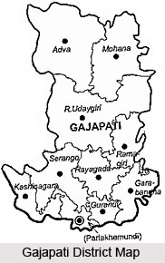 Gajapati District of Orissa was formed from Ganjam District in the year 1992 with its headquarters at Paralakhemundi. This district of Orissa is named after Maharaja Sri Krishna Chandra Gajapati who extensively contributed to the social and educational development of the region. Paralakhemundi and Kashinagara are two largest towns of Gajapati District. Gajapati District is bounded by Andhra Pradesh in south, by Ganjam District in its east, by Rayagada District in the West and by Ganjam and Phulbani districts in the North. Gajapati District occupies a total area of 3,850 sq km.
History of Gajapati District
 The history of Gajapati still echoes the long gone days of the history of Gajapati rulers in the district. Since the tract of the Gajapati was the part of the old Gondowana land, the district existed even in the prehistoric ages. But the historical documents of Gajapati are accounted from the time when, Krushna Chandra Gajapati Narayan Deo ascended the throne of the Gajapati district. Due to the non-existence of any archeological evidences, the authentic historical documents of the prehistoric ages are unavailable
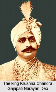
The king Krushna Chandra Gajapati Narayan Deo of Paralakhemundi had the kinship of the majestic Gajapati rulers, who continued to be the supreme authority of Orissa for more tan seven centuries. The boundary of Orissa, during that time was extended from the Ganga in the North to Udoyagiri in Nellore district in the South including the entire district of Ganjam. When Kolahomee, one of the sons of Kapilendra Deo, at the later half of the 15th century conquered this part of Orissa, he installed the kingdom and the Raj family of Paralakhemundi.
As the past history of Gajapati relates, Paralakhemundi was a zamindary estate at that time, situated at the western nook of the southernmost part of the Ganjam district. At that time the Maliya tribals dominated the land. The entire tract of Paralakhemundi was bordered by Vizagpatnam in the north and Eastern Ghats in the South.
The history of Gajapati is not apparent enough to indicate the origin of the district or the contemporary socio-economic life. The available historical records depict that the Gajapati district has been named according to the Maharaja Sri Krushna Chandra Gajapati Narayan Deb, the ex raja Sahib of Paralakhemundi (he was even the first Prime Minister of Orissa, after the independence). It was Gajapati Narayan Deb, who constituted Orissa as a separate province in the Indian Union and finally merged the Paralakhemundi estate to the province of Orissa. The present district of Gajapati came to be existed as a separate functioning unit from 2nd October 1992.
Geography of Gajapati District
Major part of Gajapati District has a hilly terrain and undulated topography, which is inhabited by the tribal people. The highest mountain of the district Mahendragiri lies at an altitude of 4,923 feet above the sea level. The soil quality is alluvial, brown, land Lateritic, clay loam, sandy loam and red soil. The geographical formation of the district is Alluvial, brown land Laterite, Newer Dolerites and Archon comprising igneous and metamorphic rocks. The main soil types are clay loam, sandy loam and red soil. The normal rainfall received in the district is 1403.30 mm. The soil and climate is suitable for plantation crops and there is a great potential of horticulture development in Gajapati District. More than 60 per cent of lands are situated in hilly terrain, which has been treated as high lands, mainly suited for horticulture plantation and other cultivable land belongs to the category of medium lands and low lands.
The mountains contain no exploitable mineral of economic value. However, the major economic minerals in the district are granite decorative stones found in some part of the Paralakhemundi Tehsil. Vansadhara River and Mahendratanaya River are two important rivers of Gajapati District. River Vansadhara originated from Lanjigarh area of Kalahandi district and passes through Kashinagar block and flows southwards along the border of Gajapati District. Mahendratanaya River originated from the Mahendragiri range and flows in the westward direction through Rayagada block and then to southward direction through Gosani block. Another river Badanadi flows through western part of Mohona block. Geography of Gajapati District also comprises huge forest land. The major forest products are Timber, Bamboo, Hill Broom, Patala Garuda, etc.
Culture of Gajapati District
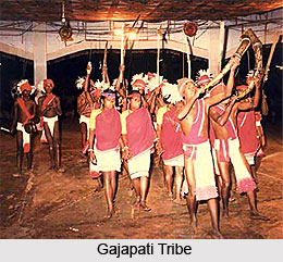 Gajapati is the dissected part of the erstwhile Ganjam district. Therefore the inhabitants of the Gajapati district belong both from the former Ganjam district and the present Gajapati. However the culture of Gajapati, in spite of being multi-ethnic , represents a culture dominated mainly by the tribals. The Saouras who are considered the oldest tribes in India are the native inhabitants of the Gajapati district.
The cultural traditions of Gajapati district are evident from the socio-economic life of the traditional native Saouras in the district of Gajapati. The Saouras are primarily the hunter community. It is believed that that the name of the tribes has a close affinity with the occupation of the tribes. The term saora is supposed to have derived from the Scythian word "Saggoriss" meaning axe that conforms to their primitive occupation of hunting. Though in the recent times most of the areas of the Gajapati district are urbanized , in the suburban areas, the tribes predominate, hence the culture of Gajapati has the essence of tribal culture.
Following the economic set up, the Saouras are categorized into two economic classes- The Saouras of the hilly areas practicing shifting and the terrace cultivation around the hilly slopes and the Saouras of the plain land depending on the wet cultivation or wage earning and selling firewood. The socio-economic foundation and their cultural habits are significantly different from one another, which dominates the Culture of Gajapati to a large extent. The Saouras of the plains in some cases are subservient to the affluent community of the hilly areas and provides labor to them and the non-tribal communities at the time of weeding, transplanting, harvesting and other agricultural operations and sell firewood and leaf plates in the local markets.
The tribal culture of Gajapati is evident from the linear pattern of the village planning. Each of the village is consisted of two rows of houses facing each other separated by a long narrow village street .
The religious beliefs of the Saouras influenced the cultural life of Gajapati to a large extent. The spirits mainly dominates the religious life of the Saouras and their culture is marked with elaborate ceremonialism and ritualism. To control the curses of the spirits and the and to protect themselves from the evil spirits they worship various aspects of nature, they believe as the controller of those spirits.
The art and craft symbolizing the family deity, sun and moon are of anthropromorphic form. The art and craft at the same time symbolized the rural culture of Gajapati. The tribal dance is also an important facet of the cultural traits of Gajapati. Men Women and the children flocked and dance together during the ceremonies and the marriages. Except during the marriage ceremony, the religious dances are hardly accompanied with music. in some cases the dance of the Saouras, also becomes a source of earning livelihood. The dress habits of the Saouras are very simple and are supplied by the Dama caste. The dress of a lady consists of a waistcloth with a gray borders hardly reaching the knee. The men`s dress consists mainly of a loincloth. The bangles, necklace of glass, clay, kaincha or gunja laced with thread or wire plastic or horn beads, wooded and metal ear rings, brass hair pins, brass rings, little rings of nose, metal bangles and anklets etc are the principal jwellery of the Saouras. The cultural life and characteristics of the Saouras mainly constitute the cultural life and habits of Gajapati district.
Economy of Gajapati District
Economy of Gajapati District is agrarian in character. The geography and the climate are favorable for production of crops like paddy, sugarcane, sunflower, oilseeds, etc. This town behaves as a nodal point for accumulation and marketing of such products. Except a few agro-processing units, there is no major industry in this district. However, some activities of cottage industries like Horn work, Jaikhadi bag, Cane and Bamboo work, Ganjappa Card and Pattachitra Mukha, Broom work and Siali leaf plate making and Tibetan Woolen Carpet contribute to the economy of the district.
Tourism of Gajapati
 The tourism of Gajapati is popular enough for the historical significance of the place. Moreover the place is profused with immense interesting sites, which are profitable to the tourism industry of Gajapati. Presently the tourism industry is one of the significant contributors to the State`s economy.
5 km from Paralakhemundi towards Gumma below the forest of Deva Giri is located the Adarsh Krushi Farm. Maharaja Krishna Chandra Gajapati founded it as the member of Royal Agricultural Commission, which is presently one of the key interests in the tourism industry of Gajapati especially because of the immaculate freshness of the surrounding area. Presently the hybrid varieties of plants are brought and planted on the agricultural firm on an experimental basis. The Adarsh Krushi Farm has now converted into a mango orchard where a variety of hybrid mangoes are grown.
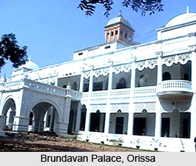
Brundavan Palace, made by the Gajapati king for their recreation during the leisurely summer, surrounded by the thick teak trees on the bank of Mahendratanaya, in the recent times constitute to be one of the important sites in the tourism of Gajapati. The chief attraction about the palace is the structural pattern and the beautiful fabrications and the artistic tapestry around the palace building. The three storeyed palaces with an underground floor, which is directly connected with the main chamber of the king represents the traditional building patterns and the interior decorations were in practice during that period. The key interest in the tourism industry of Gajapati, the Brundavan Palace is now maintained by the Government in Education Department. The P.G classes of the S.K.C.G College are held in the building and the administrative office of the IGNOU, Orissa has its functioning body in the building. The place is ideal as a picnic spot especially during the winter.
The health resort of Serango is significant in the tourism industry of Gajapati especially because of its scenic beauty and the historical significance of the place. Serango murmurs the historical "Paik unrest" during the British imperialism in India. For the immaculate freshness surrounding it, Serango is considered as an important health resort. Serango is popular with he name of "Kashmir of Gajapati" in the tourism industry.
Mahendragiri is a pilgrim center, 4500 ft above the sea level. It is the temple of the presiding god of Gajapati, Lord shiva. It is visited by a vast chunk of tourist including the pilgrims during the occasion of Mahashivaratri. The tourism, though centers round the Mahendragiri temple, the historical relics that are found in plenty in the surrounding regions of the Mahendragiri temple are no less important. The temple of Kuni, Judhisthir and Bheema are located at the hilltop are also of profound interest, offered by the tourism industry of Gajapati.
Among the other sites of worth seeing, mention may be made of Gandahati, the famous waterfall, surrounded by the dense forest. Tourist arrives here throughout the year. Chandragiri, locally known as the Tibetan colony is another important center in the tourism industry of Gajapati. The scenic beauty of the place is mainly due to the horticulture cultivation adopted by the Government. The cultural activities of the Tibetans are an added attraction to the exquisite beauty of the place. The irrigation project and the Pisciculture, which is in operation in the recent times with the government intervention, have made the place an ideal picnic spot specially during the winter.
However the tourism industry of Gajapati has a lot to offer to the visitors, throughout the year.


