 Rivers in Korea District thrives to add to the physiographical topography of the place. Korea District is an erstwhile princely state of British India was carved out from Surguja District on 25th May 1998. Three rivers adorn the valley of Korea.
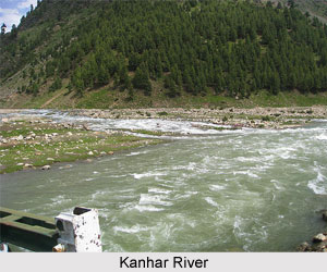
Kanhar River
Kanhar River starts its journey from Gidha-Dhodha on the Khudia plateau in Jashpur tahsil of Raigarh district and flowing northward, forms the eastern boundary of district with Palamau district of Bihar state. This river flows for 100 Kms in district. It is fed by small tributaries - Suria, Chana, Sendur and Kursa on it`s left bank and Galphulla, Semarkhar, Riger and the Cherna nallah on it`s right bank. A number of waterfalls are located along the track of the river. Pavai fall near Kothali village (Balrampur District) is of about 61 meters. A plan for massive Hydro-electricity project was set up here since last two decades.
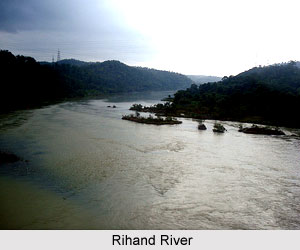 Rihand River
Rihand River has as Rend or Rehar, rises in the region southwest of the Mainpat plateau, which is about 1,100 meters above mean sea level, from Matiranga hills. The river flows north roughly through the central part of the district for 160 Kms. The Rihand and its tributaries form a fertile plain in the central district stretching around Ambikapur to Lakhanpur and Pratappur. It`s principal tributaries are the Mahan, the Morana(Morni) ,the Geur ,the Gagar ,the Gobri ,the Piparkachar , the Ramdia and Galphulla. A medium irrigation project is working on Ghungutta River, since 1981, near Darima Air Strip under taken by World Bank, Which is about 15 kms from Ambikapur. The Mahan is a perennial river, on which medium Multipurpose project is under implementation as well as consideration by Central water Commission.
Hasdeo River
The Hasdeo is the largest river flowing towards the South that rises from 23§30` North by 82§30` East on the Sonhat Plateau and drains the South-Western part of the District. As witnessed in this region the river course resembles an upturned `S` and flows for about 95 km. After a course of about 72 km, it enters Bilaspur District at 23§ north. The river is nourished by further body of waters of the Gej and the Chornai on the left bank and the Tan and the Ahiran on the right as and when it is on it way of mating with Mahanadi. The total length of the river is 245 km. The valley is narrow. Important settlements along the river are Sonhat River, Ghugra River, Manendragarh River, Kosgain River, Korba River and Atem River.
Gej River
Gej is another river that supposedly rises from the Hills west of Central Plateau. It flows post Baikunthpur and receives the Jhink and the Atem from the left. It drains into the Mahanadi River through the Hasdeo. Rising from the North-Eastern slopes of the Mainpat, the Mand flows in the South-Eastern part of the District and further it flows in Raigarh and Bilaspur Districts. It drains into the Mahanadi.
Gopad River
Gopad River rises from the Northern slopes of Sonhat Plateau (23§32`North, 82§31`East) in Surguja. It flows to the North and the West in stages. In Sidhi District, the Gopad flows first to the west along the common boundary of Bharatpur Tehsil with Sidhi District. The river then meanders to the North and North-West and final North-West and finally to the North-East. The river is joined by the Goini and the Neur in Surguja, and the Sehra, the Kandas and the Mohan in Sidhi. The stream meets the Son near Bardi.


