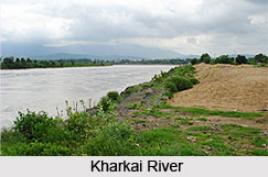
 Kharkai River is a rain fed river in eastern part of India. It is one of the major tributaries of the Subarnarekha River. Kharkai River originates in the Chhota Nagpur Plateau. The river flows through the regions of West Singhbhum, Seraikella, East Singhbhum and Bokaro and finally reaches Sakchi at Jamshedpur where it merges into the Subarnarekha River. The meeting point of the rivers is popularly known as the Rivers Meet, nearby which lies the Tata Steel Zoological Society of Jamshedpur. The river bank is one great spot for tourists and the people of Seraikella to visit. One can spend hours watching the scenic sunsets and sunrise on its banks.
The valley of the Lower Kharkai River is quite wide and the soil of that region is very fertile. The soil is rich in alluvial soil. The cultivation of rice is the primary job in this region. The Iron ore is mined in the mountains of the headwaters of the Kharkai, and there is a steel plant established at Jamshedpur. The Kharkai Dam is located on the Kharkai River at Ichha, Orissa.
Source of Kharkai River
The source of the Kharkai River is in the Mayurbhanj district of Orissa. The spot is situated on the north slopes of Darbarmela Parbat and the western slopes of Tungru Pahar of the Simlipal Massif. The tributaries of Subarnarekha River in Orissa include the Kharkai River, on the left part of Orissa; the Kandria River, Nusa River and Barhai River on the right part of the state; and the Karanjia on the left.
Etymology of Kharkai River
The name Kharkai is derived from the Sanskrit word "Kharakaya" meaning "fast flowing river".
Course and Tributaries of Kharkai River
For about 9 km below, the junction with the Karanjia River, the Kharkai River forms the boundary between Orissa and Jharkhand State. After entering in Jharkhand, the distributaries of Kharkai River include the Torlo River and Ili Gara River on the left portion of the State. The major distributory of the Kharkai River is the Sanjai River. After that the Kharkai River is entering from the left that is 17 km, as the river flows, above its mouth. The middle course of the Kharkai River is that the river flows past through the Rairangpur and heads north to about Seraikella and then east. After that the Kharkai River is entered in the Subarnarekha River in north-western part of Jamshedpur.