Introduction
 Korea is one of the North-West District of Chhattisgarh State. The District came into existence on 25th May 1998 in Madhya Pradesh. Its parent District was Surguja. After the formation of New State of Chhattisgarh on 1st November 2000, the district came under the Chhattisgarh State. Korea District has derived its Name from the Korea State, the former princely State Korea.
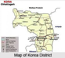
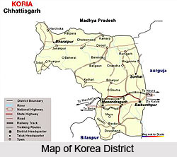
Korea district is bordered by Shidhi District of Madhya Pradesh on the North, Bilaspur Districts on the South, on the East by its parent Surguja District and on the West by Shahdol District of Madhya Pradesh. Koriya District lies between 22degree 56 minutes and 23 degree 48 minutes North and 81degree 56 minutes and 82 degree 47 minutes East.
History of Korea District
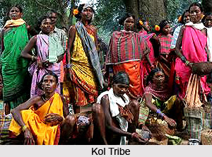 The History of Korea District dates back to 1600. According to Dalton, Balands were the actual rulers of Korea who had their capital in Sidhi. There are still remnants of the ruins of the works accomplished by them. However, later a united force of the Kol Raja and Gonnd Zamindars overthrew the Baland rulers from Korea. The Kols also known as Konch Kols ruled for Eleven Generations. According to one view the Kols had their Capital at Koreagarh while others suggest that it was village Bachra near Podi.
In early 17th century, two cousins of the Agnikul Chauhan Raja of Mainpuri, Dalthmban Sahi and Dharamal Sahi were returning after pilgrimage to Jagannath Puri along with a small force. While returning they stopped at Bishrampur, the Capital of Surguja State. During their stay some rebel sardars of the State attacked the place. The king was away hence the queen sent the traditional Rakhi to the Chauhan brothers asking for help. The brothers came to her rescue and drove away the bagi sardars. After the Maharaja returned, he thanked the Chauhan brothers for their act and offered them the Jagirdari of the area on the Eastern part of the State known as Jhilmili. A part of Jhilmili Area was under control of Baland Rajas.
The Chauhan brothers settled at Kaskela village on the banks of the River Rehar. They drove away the Baland from the area. They paid an Annual Tribute to the Surguja State. The title of Bhaiya was bestowed upon the family by Maharaja Amar Singh since after the tying of the Rakhi, the brothers had become bhaiyas of Rani. This was later known as Bhaiyathan. The younger brother Dharamal Sahi stayed with his brother at Kaskela but later decided to build his own kingdom. He gathered a force and moved westward beyond the boundary of Surguja District into Korea State, which was ruled by a Kol Raja.
He defeated him in a battle and took over the Kingdom of Korea. Dharamal Sahi drove away Balands from the Northen territory of Korea State. Dharamal Sahi had three sons Deoraj Sahi, Adhorai Deo and Raghorai Deo. On the death of Dharamal Sahi his eldest son Deoraj Sahi ascended to the throne. As the eldest son had no child his younger brother`s son Raja Narsingh Deo became the next king. He was succeeded by his son Raja Jeet Rai Deo. He was followed by his son Raja Sagar Sahi Deo. On his death, his son Raja Afhar Sahi Deo ascended the throne. His son Raja Jahan Sahi Deo succeeded him. He was succeeded by his son Raja Sawal Sahi Deo. On his death his son Raja Gajraj Singh Deo became the King. He was issueless and was succeeded by his nephew Raja Garib Singh son of Lal Dilip Singh Deo. Raja Garib Singh`s younger brother Lal Man Singh was given a Jagir, which was named Changbhakar. He became the Jagirdar of Changbhakar, which had its capital at Bharatpr. Raja Garib Singh was born in 1745 at Nagar. Near about 1765 the forces of Bhosle`s of Nagpur attacked Nagar and forced Raja Garib Singh to pay Chauth. He paid the Chauth for some time and then stopped paying the same to the Marathas. He moved his Capital to Rajauli and then to Sonhat. The capital was moved to the interior for fear of Maratha attacks.
In 1797 the Marathas under Subedar Gulab Khan attacked Sonhat and forced Raja Garib Singh to pay Chauth. Gulab Khan who was the Maratha Subedar came with 200 soldiers and ravaged the countryside. On their return journey at Latma Village, the forces of Patna Zamindar attacked them. The Marathas beat a hasty retreat into Surguja State. After the defeat of Modeji Bhosle of Nagpur by the British East India Company, the Chhattisgarh States came under the suzerainty of the East India Company. In the Kabuliat executed on 24th December 1819 by Garib Singh, it was decided that Korea State will pay an annual tribute of Rs. 400. Raja Garib Singh was succeeded by Raja Amol Singh but he proved to a weak Raja. Hence the State was virtually ruled by his wife Rani Kadam Kunwar. After the death of Amol Singh in 1864 his son Raja Pran Singh became the next king.
As Pran Singh Deo was issueless after his death Raja Sheomangal Singh Deo became the next king. Raja Sheomangal Singh Deo moved his capital from Sonhat to Baikunthpur in the year 1900. He also constructed the two tanks and a temple, which are near the new palace. After his death his eldest son, Raja Ramanuj Pratap Sing Deo became the king. As he was a child the State was put under court of wards with Gore Lal Pathak Superintendent of Korea State. He continued till 1916. Pandit Gangadin Shukla took over from him and continued till 1918. He was followed by RaghubirPrasad Verma. Finally In January 1925, Raja Ramanuj Pratap Singh Deo was invested with full ruling with full ruling powers and continued till the merge the Korea State in to independent India. Raja Ramanuj Pratap Singh Deo represented the ruling Chief, in the second Round Table Conference held in London in 1931. Under his rule the income of the Korea State rose from 2.25 lakhs to 44 lakhs in 1947-1948, and there was a reserve of over rupees one crore when the State was merged with Central Provinces and Berar. In this duration so many works were done. In 1928, construction of Bijuri - Chirimiri Railway Line started and completed on 1931. In 1928 Chirimiri Colliery opened by Bansi lal Abirchand. In 1928 Khurasia collery is started. In 1929, Jhagarakhand Colliery is opened. In 1930 railway communication to Manendragarh is started. In 1935 Ramanuj High School opened. On 15th December 1947, Raja Ramanuj Pratarp Singh Deo signed the merger agreement by which the state was merged to the Central Provinces and Berar and finally 1st January 1948, State is merged with Central Provinces and Berar.
Geography of Korea District
 Korea is a North-West District of the Indian state of Chhattisgarh. The District came into existence on 25th May 1998 in Madhya Pradesh State. Its parent District was Surguja. After the formation of New State of Chhattisgarh on 1st November 2000, the District came under the Chhattisgarh State. The District has derived its name from the Korea State, the former princely State Korea.
Korea district is bordered by Shidhi District of Madhya Pradesh on the North, Bilaspur Districts on the South, on the East by its parent Surguja District and on the West by Shahdol District of Madhya Pradesh. Koriya District lies between 22degree56` and 23degree48` North and 81degree56` and 82degree47` East. The area covered by the district is 5978 kms, of which 59.9% is forest area. The height from Sea Level is 700 metres. The general height of the lower tableland is 550 m (1800 feet) above sea level. The Sonhat Plateau has a maximum elevation of 755 m (2477 feet). The highest peak in the Deogarh District is 1027 m (3370 feet) high. The district receives an average rainfall of 1410.9 mm. The climate is mild with a bountiful monsoon, a mild summer and a bearable winter.
Resources of Korea District
Korea District has vast resources that form the basic asset of the district. The different types of resources of the district are:
Minerals of Korea District
Korea District has vast reserves of Coal. The main coal belts are in the Hasdo basin. Major deposits of these coals are in Chirimiri, Jhagrakhand, Curcha, Katkona, Pandavpara and Sonhat, Nagar, Amritdhara, Gutra, Kilhari, Pathargaon and Damuj-Labji. There are also small deposits of limestone, fire clay and red oxide in Korea District.
Drainage of Korea District
Small portion of Korea District lies in the Ganga basin and the remaining part is in the Mahanadi basin. The Ganga basin starts from the North of Sonhat beyond Mendra village and from Mendra Southward is the Mahanadi basin. The major tribute of Son is Gopad that originates about 10 miles North of Mendra village. It drains the Northern portion of the District. A major tributary of Mahanadi, Hasdo has its origin in Mendra village. The main tributaries of Hasdeo are Gej, Jhumka and Bania. The Eastern Area of the District comes in the Son basin and is drained by Gobri River which meets the Rehar in Surguja District. Gobri has its origin in the hills North of Patna.
 Forests of Korea District
District Korea has vast range of forests. These forests play a very important role in the economy of District. There are different types of flora available in the district like Saja, Sal, Mango, Mhua, Sisham, Gamhar, Harra, Jamun, Tendu, Khair, Kusum, Imli, Bija, Aurjun, Sandan, Palas and others.
Coal Fields of Korea District
The District is very rich in Coal. The main Coal fields are as follows:
Chirimiri Coalfields: Seven main Coal mines are situated under this area. They are Chirimiri, Kurasia, N.C.P.H., Korea, Domanhill, Gelhopani (North Chirimiri) and West Chirimiri. Basically two methods are used by S.E.C.L (South Eastern Coal fields Limited under Govt. of India) for the production of coals are Open Cast and under ground Mining Systems. Grade of Coal is A and B.
Baikunthpur Coalfields: Main coal mines in this area are Charcha, Pandavpara, Katkona under the Baikunthpur coalfields.
Jhagrakhand or Hasdev Coalfields: This is another important coal mine in Korea district.
Rivers of Korea District
There are various types of rivers in Korea District that are mentioned below:
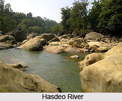
1. Hasdeo River: The Hasdo is the largest river flowing towards the South. It rises from 23degree30` North by 82degree30` East on the Sonhat Plateau and drains the South-Western part of the District. In this District, the river course resembles an upturned `S` and flows for about 95 km. After a course of about 72 km, it enters Bilaspur District at 23degree north. It receives the waters of the Gej and the Chornai on the left bank and the Tan and the Ahiran on the right before it meets the Mahanadi. The total length of the river is 245 km. The valley is narrow. Important settlements along the river are Sonhat, Ghugra, Manendragarh, Kosgain, Korba and Champa.
2. Gej River: The Gej rises from the Hills west of Central Plateau. It flows post Baikunthpur and receives the Jhink and the Atem from the left. It drains into the Mahanadi through the Hasdo. The Mand flows in the South-Eastern part of the District. Further it flows in Raigarh and Bilaspur Districts. It drains into the Mahanadi River.
3. Gopad River: The Gopad rises from the Northern slopes of Sonhat Plateau (23degree32`North, 82degree31`East) in Surguja. It flows to the North and the West in stages. In Sidhi District, the Gopad flows first to the west along the common boundary of Bharatpur Tehsil with Sidhi District. The river then meanders to the North and North-West and fina North-West and finally to the North-East. The river is joined by the Goini and the Neur in Surguja, and the Sehra, the Kandas and the Mohan in Sidhi. The stream meets the Son near Bardi.
Culture of Korea District
Culture of Korea District delineates uniform spirit of merriment within the region of Korea District. They also portray the culture of Korea District. There are basically three community dances which are celebrated mainly in the District during different festivals and functions are Karma, Suga and Saila Dance.
Suga Dance
This is basically a dance of the women folk. Like the saila, the women use small stick in the same way expects that there is no down ward movement of the stick. They move in circle dancing and singing. A pot containing rice with a few wooden parrots coloured with paint is placed in the centre. Ganga Dashera is celebrated on Bhim Seni Ekadashi which heralds the sowing of Kharif crops. There are folk dances in which men, women, boys and girls dance together singing romantic songs. Liquor is taken by the dancers and this leads to spirited and vigorous dancing. It is especially of festival of rejoicing.
 Charta Dance
Charta dance is celebrated on the Purnima (Full moon day) in Pausha month. At this period of the year, the cultivator brought home his Agricultural produce. Every family has a sumptuous mid day meal according to their financial status. Children go out in the village and collect rice from every household. In the evening, the young maids of the village cook the collected food near the village tank or on the banks of river or rivulet and then they have a community feast. Charta is celebrated by all the communities. It is essentially a festival to celebrate the harvest.
Saila Dance
Saila dance is performed with many variations in dancing style and pattern. Sometimes the dancers stand in forming a circle, where each one is standing on one leg and taking help for support by holding on to the man in front. Then they all dance together taking round and round. Sometimes, they pair off or go round in a single or double line, occasionally, climbing on each other`s back. Saila dance can be performed in number of ways. Some of them are named as the Baithiki Saila Dance, the Artari Saila Dance, the Thadi Saila Dance, the Chamka Kunda Saila Dance, the Chakramar Saila Dance (lizard`s dance) and the Shikari Saila Dance. Each form of variation is based on a certain theme and distinctive feature as its own identity.
Saila Dance in its simplest form is performed as the Dasera dance that is always performed by the Baigas before festival of Diwali. Some of the post-harvest dances like Saila reach the climax towards the festivities of Diwali. Such dances of the Ahir Tribe and Rawats of Bilaspur and Raipur districts of the state have a vital appeal.
Festivals of Korea District
 Festivals of Korea District are infested with the clouds of merriment and mirth and bring out the spirit of the people. As and when the month of September rolls around, the temperatures commences to drop one can hear from the surrounding ambience a collective sigh across the nation as people ubiquitously ultimately sense relief from the summers sickly sweet scorching heat.
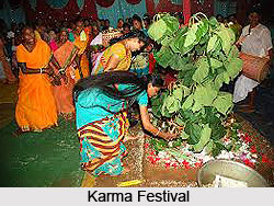
Karma Festival
Karma Festival is celebrated on Bhadrapad-Suklapaksh Ekadashi. And in the auspicious festival the Karma dance is attuned to the rhythmic vibrations of the festival. This festival comes after the Agriculture operation of Kharif is completed. It is one of the main festivals of all Korean. After the completion of the agriculture operations, the community prays to God named "Karma Dev" for the bumper harvest.
It also signifies a celebration after the hard labour they have gone through the Agricultural operations. Young boys and girls fast during the day and in the evening bring a branch of the tree "Karam Tree" and plant it in the varandah of the house of the head of their community. Java and wheat is germinated a few days earlier and the small plants are put in a small bamboo basket and placed before the branch of the Karam Tree. This branch represents Karam Deo. A lamp is lit and placed before Karam Deo.
In the month of Aghran, the villagers go to the adjoining villages to perform the Saila Dance. According to Dalton, it is a dance of the Dravidian Community. They have small sticks of their hand and this stick is struck at the stick of the person dancing next to him. They move in circles in clockwise direction, and then they turn around and move Anti-clockwise. The "Mandar" gives the beat to the dancers. When the beat becomes fast, the dancers also move faster. The sticks are once hit against each other when the arms are stretched upwards and then when the arms come down.
Navakhai Festival
Navakhai is the festival which is celebrated by Agriculturists of all communities. When the paddy harvest starts, the new rice is offered to the family Deity on the Navmi preceding the Vijaya Dashmi. There is a religious ceremony and after this the family takes the "Prasad". After this the family starts consuming the rice. In the evening some communities perform dances and take liquor.
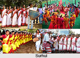
Sarhul Festival
Surhul is celebrated when the Sal Tree starts flowering. Only some communities celebrate this festival. Mother earth is worshipped on this day. It is prohibited to plough the fields or do any form of digging of the Earth. Villagers go to the village "Sarna" (A small patch of forest within the village) and worship there. The Oraon tribe celebrate the marriage of the Sun God to Mother Earth.
As autumn spreads its wings in Korea, with mild temperatures and gentle breezes, is an ideal time to indulge in a voyage. Festivals are among the most unique events in Korea, and from September to November they seem to pop up almost everywhere. The Crops ripen to the brim and are harvested during this time, giving festival-goers a chance to sample fresh, delicious treats and local delicacies.
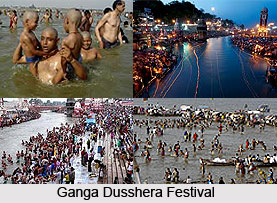
Ganga Dashera Festival
Ganga Dashera is celebrated on Bhim Seni Ekadashi that heralds the sowing of Kharif strops. There are folk dances in which men, women, boys and girls dance together singing romantic songs. Liquor is taken by the dancers and this leads to spirited and vigorous dancing. It is especially of festival of rejoicing. It is celebrated on the Purnima (Full moon day) in Pausha month. At this period of the year, the cultivator has harvested and brought home his Agriculture produce. Every family has a sumptuous mid day meal according to their financial status. Children go out in the village and collect rice from every household. In the evening, the young maids of the village cook the collected food near the village tank or on the banks of river or rivulet and then they have a community feast. Charta is celebrated by all the communities. It is essentially a festival to celebrate the harvest.
This is the festival which is celebrated by Agriculturists of all communities. When the paddy harvest starts, the new rice is offered to the family Deity on the Navami preceding the Vijaya Dashami. There is a religious ceremony and after this the family takes the "Prasad". After this the family starts consuming the rice. In the evening some communities perform dances and take liquor. This festival is celebrated when the Sal Tree starts flowering. Only some communities celebrate this festival. Mother earth is worshipped on this day. It is prohibited to plough the fields or do any form of digging of the Earth.
 Villagers go to the village "Sarna" (A small patch of forest within the village) and worship there. The Oraon community celebrate the marriage of the Sun God to Mother Earth.
Festivals in Korea district combine some of the most fascinating elements of History of Korea District and culture, arts, and food, making each festival a unique reflection of each region`s local flavour. In Korea, there seems to be a festival for just about everything. There is a ginseng festival, a fireworks festival, a festival celebrating the country`s UNESCO World Cultural Heritages, a herbal medicine festival, a drum festival, and of course, a Kimchi Festival- not to mention many others happening all across the peninsula.
Rivers in Korea District
 Rivers in Korea District thrives to add to the physiographical topography of the place. Korea District is an erstwhile princely state of British India was carved out from Surguja District on 25th May 1998. Three rivers adorn the valley of Korea.
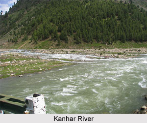
Kanhar River
Kanhar River starts its journey from Gidha-Dhodha on the Khudia plateau in Jashpur tahsil of Raigarh district and flowing northward, forms the eastern boundary of district with Palamau district of Bihar state. This river flows for 100 Kms in district. It is fed by small tributaries - Suria, Chana, Sendur and Kursa on it`s left bank and Galphulla, Semarkhar, Riger and the Cherna nallah on it`s right bank. A number of waterfalls are located along the track of the river. Pavai fall near Kothali village (Balrampur District) is of about 61 meters. A plan for massive Hydro-electricity project was set up here since last two decades.
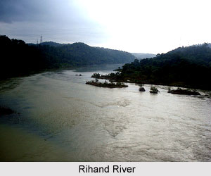 Rihand River
Rihand River has as Rend or Rehar, rises in the region southwest of the Mainpat plateau, which is about 1,100 meters above mean sea level, from Matiranga hills. The river flows north roughly through the central part of the district for 160 Kms. The Rihand and its tributaries form a fertile plain in the central district stretching around Ambikapur to Lakhanpur and Pratappur. It`s principal tributaries are the Mahan, the Morana(Morni) ,the Geur ,the Gagar ,the Gobri ,the Piparkachar , the Ramdia and Galphulla. A medium irrigation project is working on Ghungutta River, since 1981, near Darima Air Strip under taken by World Bank, Which is about 15 kms from Ambikapur. The Mahan is a perennial river, on which medium Multipurpose project is under implementation as well as consideration by Central water Commission.
Hasdeo River
The Hasdeo is the largest river flowing towards the South that rises from 23§30` North by 82§30` East on the Sonhat Plateau and drains the South-Western part of the District. As witnessed in this region the river course resembles an upturned `S` and flows for about 95 km. After a course of about 72 km, it enters Bilaspur District at 23§ north. The river is nourished by further body of waters of the Gej and the Chornai on the left bank and the Tan and the Ahiran on the right as and when it is on it way of mating with Mahanadi. The total length of the river is 245 km. The valley is narrow. Important settlements along the river are Sonhat River, Ghugra River, Manendragarh River, Kosgain River, Korba River and Atem River.
Gej River
Gej is another river that supposedly rises from the Hills west of Central Plateau. It flows post Baikunthpur and receives the Jhink and the Atem from the left. It drains into the Mahanadi River through the Hasdeo. Rising from the North-Eastern slopes of the Mainpat, the Mand flows in the South-Eastern part of the District and further it flows in Raigarh and Bilaspur Districts. It drains into the Mahanadi.
Gopad River
Gopad River rises from the Northern slopes of Sonhat Plateau (23§32`North, 82§31`East) in Surguja. It flows to the North and the West in stages. In Sidhi District, the Gopad flows first to the west along the common boundary of Bharatpur Tehsil with Sidhi District. The river then meanders to the North and North-West and final North-West and finally to the North-East. The river is joined by the Goini and the Neur in Surguja, and the Sehra, the Kandas and the Mohan in Sidhi. The stream meets the Son near Bardi.
Hunting in Korea District
 Hunting in Korea District is the chief source of livelihood of the people and thus portrays the essence of the tribal culture and life in totality.
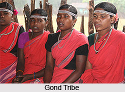
The Bhuinhar (Known as Pando), the Gond Tribe and the Cherwas were the traditional hunters. They used bows and arrows. Some arrows were poisoned. The poison was applied on the lower portion of the arrow. They either sat on water holes of wild animals or arranged small Hakas (beats). The good bowmen would sit at selected places. The others would drive the animals and when the animals came within twenty yards the bowmen would release their arrows. The bow used to have a thin bamboo strip connecting the two ends of the bow. This was pulled by the second and third finger, the legend goes that Eklavya (One character of Mahabharata) had lost his thumb as Guru Dronacharya had demanded his thumb as Guru Dakshina, so ever since then the tribal community do not pull the bow with the help of the thumb. Dogs were also used in the Haka or beat.
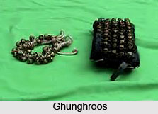
They were used to locate animals and search for the wounded animals. Rabbit hunting was done in small fields. Three sides of the field were barricaded by small branches of trees. The rabbits were driven in to it through the open side and then they were beaten to death. A special way of hunting was practised by the use of musical sounds. A Jhumka, which makes a musical sound, was used. It consists of an iron rod at the end of which are a number of small chains with Ghunghroos and rings.
In the night a group of people formed a party, and went to the forest where they could find deer and rabbit. In place of torch, they kept a small pitcher which had a three inch circular hole in the centre. In the pitcher they placed burning bamboo sticks, the flames threw a light which was projected through the hole in the pitcher. This acted like a torch. One person played the Jhumka, the rhythmic music attracted rabbits and deer. They came near and were sort of hypnotised by the music. When they were within reach one or two persons of the party kept in front and beat those sticks. It is said that some times even panthers and tigers were attracted by the music. In such cases the group gradually slowed down the music of the Jhumka and gradually withdrew from the forest.
Wild partridges were caught with the help of a tamped partridge. The tamed partridge was kept in a cage near a tree. The cage was camouflaged with leaves. A net was placed encircling the cage. The owner of the tamed partridge sat on the top of the tree. The partridge was trained to perch when the owner started whistling. Once the partridge started perching, the wild partridges from nearby bushes moved towards the place from where the perching sound was coming. Then they got snared in the net, sometimes eight to nine partridges were caught at a time. The tame partridge was known as Kutni.
Some communities went to the rivers in the night with flares made of Bamboo sticks. The light of the flares attracted the fish to the surface and then the villagers used a three pronged spear to kill the fish. In shallow streams bows and arrows were used to shoot the fish that came to the surface.
Birds sitting on tree were caught by what is known as Lasa. The sticky milky sap of Mahua, Bar, Peepul was mixed and kept in a small bamboo container. Very thin 18 inches long Babool sticks were dipped in the milky liquid and kept on the branches of trees where birds sat. When the birds sat on the branches, the sticky milk liquid got transferred to their wings. The stick clung to their wings. They were unable to fly and fell down. Green Pigeon, wild Peen Pigeon, wild Pigeon, Doves, Maina, Parrot etc were all brought down in this way.
Another technique practised for killing birds was by shooting birds with bow and arrow in the night. The villagers watched the birds when they came to roost in the trees for the night. In the night, they lighted a bundle of dry Bamboo sticks below the tree. The light of the fire gave them enough light to locate the bird. It was then shot with a bow and arrow. The arrow didn`t have a metal piece. It had a small wooden stump at the end. Birds were shot with this type of arrow. The wooden piece at the end of the arrow is known as Thepa.
Wild boars were killed during the Kharif season when they come to the village. Three feet wide and six feet deep long trenches were dug and the villagers drove the pigs towards this and they fell in the trench and were subsequently killed with spears. The Sambhar stag was an easy prey for the village hunters. They chased it with the help of dogs. It can not run fast in the thick forest as the long antlers get entangled in the branches or trees. It was run down and then shot with arrows.
When poison was used on the arrows then the hunters had to be careful in eating the flesh of the animal. The flesh around the arrow was thrown away. In some cases there had been casualties when they had taken flesh of animals killed by poisoned arrows.
Settlements in Korea District
Settlements in Korea District in actuality points towards the various types of populace of the Korean region and the various types of culture present owing to the fact that various types of people inhabit together.
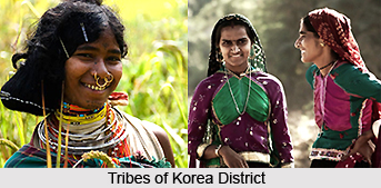
Cherva the oldest migrants may have been the Cheros of Palamau District who are known as Chervas in Korea District. According to the elders of their family, they came some four hundred years ago. Some Chervas had migrated from Palamau and settled in Changbhakar and came to Korea subsequently. They gradually settled all over the District and most of the villages had settlement of their community. Baiga or the village priest was from their community.
 The villages which did not have a village priest persuaded Cherva families to settle in their village so that the village had the services of a Baiga. Being social and helpful their community members were welcome in all the villages. Thus the Cherva community settlements sprang up all over the District. They were associated with the ruling family and received their patronage. This also led to their economic development.
Rajwars are not able to throw any light on their past history. They had a Zamindari in Korea State known as Gugra where they trace their ancestry to about Twelve Generations. So it can be assumed that they have been here for more than Twelve Generations. Probably they came two hundred to two hundred fifty years ago. Very first they came in Surguja and after some time they came in Korea. Being close to the ruling family of Korea they were given facilities to settle wherever they wanted. Originally they settled near the Rajdhani and shifted with the Rajdhani. When their population increased they cleared forests and developed new settlements. Being intelligent and hard working they became more affluent than the local people. Their earliest settlement was in Kharbet, Odgi, Bishnupur, Jampara, Bardia, Kudeti, Kathgodi, Gurga, Latma, Sardi, Kasra, Bodar etc.
Ahir and Gwalas` percentage in the population in the State is small. Their migration must have begun in the late Nineteenth Century. According to them they have mostly migrated from Singrauli, and some from Surguja.
According to the elders of their family, they have migrated from Waidhan and Singrauli in Sidhi District in the last decade of the Nineteenth Century. The original settlements were in Baikunthpur, Shadi Kharbet, Talwapara etc.
Oraon Tribe are originally from Chota Nagpur. According to their elders their ancestors came to excavate a Tank in Bishnupur village. According to Historical Records, this tank was excavated by Bai Kadam Kunwar Rani of Raja Amol Singh. The period was approximately the middle of the 19th century. It is not known if some of their ancestors had come earlier. From Bishunpur they moved to Bodar, Kudeli, Amgaon, Kasra and other areas.
Administration of Korea District
Korea District has altogether 5 subdivisions and 5 Tehsil. The district has 1 Nagar Nigam, known as Chirimiri and 3 Nagar Palika, Baikunthpur, Manendragarh, Shivpur Charcha. Jhagarakhand, Khongapani, Nai ladri forms the Nagar Panchayat. The district also has 5 blocks. There are 236 Garam Panchayat and 653 villages.
Tourism in Korea District
The Tourism in Korea District attracts many tourists to this place. Few of the tourist places in Korea are, Gangirani Jogi Math Rock Painting of Badara Ghaghara. These are the famous Archeological Places in this district. Apart from these there are many other places like Guru Ghasidas National Park, Amrit Dhara Waterfall, Korea Palace, Ramdaha Waterfall, Gaurghat Waterfalls.


