Introduction
 Kanker District is situated in the southern region of Chhattisgarh. Previously Kanker was a part of old Bastar District. But in the year 1999 Kanker District got its identity as an independent district. This district is surrounded by four districts of Chhattisgarh, namely Bastar, Dhamtari, Durg and Rajnandgaon. Kanker District is situated within the longitudes 20.6 to 20.24 and latitudes 80.48 to 81.48. The total area of the district is near about 5285 sq kms.
History of Kanker District
History of Kanker District can be traced back to the stone era. According to the Ramayana and Mahabharata, there was a dense forest area named Dandakaranya and Kanker state belonged to Dandakaranya. According to myths, Kanker was the land of monks. In the 6th century BC, Buddhism prevailed in the region. The ancient history of Kanker District reveals that it always remained an independent state.
Further, history of Kanker District shows that in 106 AD, Kanker state was under the Satvahan dynasty. After Satvahans the state was under the control of Nags, Vakataks and Gupta dynasties time to time. After the Vakataks the Kanker state came under control of Nal dynasty. After the downfall of Nal kings the state was won by famous king Pulkeshin II of Chalukya Dynasty. During his kingdom a lot of temples were constructed in Kanker state. After Pulkeshin, Vikramaditya, Vinayaditya, Vikramaditya II, Kirtiverman II were the other kings who ruled the state up to 788 AD. After Chalukya the state was ruled by several other dynasties up to 1100 AD.
As per the historical accounts, Kanker province was ruled by Som Dynasty from 1125 AD to 1140 AD. Further, after the downfall of Som Dynasty this region was ruled by Kandra Dynasty followed by Chandra Dynasty. According to some historians, Chandra Dynasty was related to Som Dynasty. They ruled the state up to 1802 AD. During the kingdom of Shyam Singh Dev, the last king of Chandra Dynasty, Marathas had started attacks on Kanker and Bastar states. Since, Kanker and Bastar were neighboring states, therefore they affected each other. Marathas won the Kanker state and eventually this province came under the control of British from Marathas. In the year 1882, control of Kanker state was handed over to the commissioner of Raipur.
In the year 1904, Komal Dev became the king of Kanker. He controlled the state with the help of his minister Anand Rao. During his kingdom, several educational institutes and hospitals were established. He established a new town near Kanker named Govindpur. He also tried to make capital Govindpur instead of Kanker. After his death, Bhanupratap Dev became the king. He was the last king of Kanker before independence of India. After the independence of the country, he was elected as the MLA from Kanker constituency twice. In 1999, Kanker was declared as an independent district.
Geography of Kanker District
 Geography of Kanker District spreads over a vast area dotted with different types of hills. These hills are ancient and can be divided in three main groups. These are Vindhyana Hill Groups, Archian Hill Groups and Dharwar Hill Groups. Vindhyana Hill Groups are spread in the south eastern part of Kanker District. Archian Hill Groups cover around 95 per cent area of Kanker District. Granite is vastly spread over almost the total geographical area of the district. Dharwar Hill Groups are considered as rough. These hills are spread over the north of Bhanupratappur. Land structure of Kanker District is not the same everywhere, it is mostly hilly.
Geography of Kanker District includes around 80 per cent plane surface that can be divided in two parts - Mahanadi plane and Kotri plane. North eastern part of Kanker District comes under Mahanadi plane. The altitude of this plane is less than 500 meters. The main river of this area is Mahanadi River. Hatkul, Chinar, Doodh, Sendoor, Nakti and Doori are the other rivers of the area. Kotri plane comes under Bhanupratappur area. Kotri River is the main river of this area. The height of this plane is less than 400 meters.
Amongst the natural resources plants have greater importance. In Kanker District, mainly Saul, Teak and mixed forests are found. Saul forests are found in the eastern part of the district, Teak forests are found in the Bhanupratappur region and mixed forests are found almost throughout the region. The forest resources are also rich in several medicinal plants.
Mainly red soil is found in this district of Chhattisgarh. In the higher region faint color soil are found and smooth and fertile soil is found in river valleys. Soils of this district can be divided into four sections.
Kanhar: This type of soil is black in color and oily. The power of water absorption in this soil is greater and this is very useful in growing of Kharif and Rabi crops in the region.
Dorsa: This type of soil is medium in nature and it is very much similar of Matasi and Kanhar type soil. This type of soil is found in north east Kanker and Bhanupratappur region.
Matasi: This type of soil is found at higher land surface than Kanhar and less than Bhata. This soil is appropriate for cultivation of rice. This type of soil is found in the maximum area of Kanker region.
Bhata: Bhata soil is appropriate for crops like Kodo, Kulthi, Maize, Bhadia and Kutki.
Development of agriculture, industries, transport and communication depends on the status of mineral resources of the region. Kanker District is poor in minerals resources. Iron Ore quartzite and garnet mines are found in the region.
Administration of Kanker District
Administration of Kanker District includes seven tehsils named Kanker, Charama, Narharpur, Bhanupratappur, Antagarh, Durgukondal and Pakhanjoor and seven blocks named Kanker, charama, bhanupratapur, Narharpurn Antagarh, Durgukondal and Koyali beda. The total number of villages is 1004. The number of revenue villages is 995, whereas forest villages are nine. The number of Gram Panchayats is 389.
Culture of Kanker District
 Culture of Kanker District includes the indigenous religion and beliefs of the local people. The culture of Kanker District is predominantly tribal as this region is mainly inhabited by several tribal communities. There were around 62 castes in Bastar and Kanker provinces. The major tribes of this district are Maria, Muria, Bhatra, Parja, Gadva, Halba Tribe, Mahra, Chandal, Ghuruva, Dom, Lohar, Matrigond, Rajgond, Dorla, Nahar, Naikpod, Kuduk, Andkuri, Kumhar, Kosta, Chamar, Kenvat and Dhakad tribes.
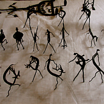
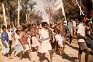
 Joint family structure is the prominent family structure in Kanker District of Chhattisgarh. Families are basically male dominant. The main languages spoken in this district are Hindi language, Chhattisgarhi language, Gondi language and Halbi language. Other languages like Bengali language, Telugu language and Oriya language are also popular in the district. There is an important festival of the tribes of Kanker District which is known as `Madai`. The festival is celebrated in January. Madai festival is celebrated for seeking the blessings of goddess Kesharpal Kesharpalin Devi. This festival is basically a moving festival and moves throughout Kanker District, Bastar District and Dantewada regions from December to March. This festival is celebrated in a big ground where thousand of peoples gather. Firstly, tribes arrange a procession of local god and goddess that is followed by prayers and then the celebration of the festival starts. A lot of shops, crafts, dances and other cultural programmes can be seen in this festival. Several people from other regions come to that place and enjoy the festival. Other festivals like Mati-tihar, Gobar-boharani, Ramnavmi, Navakhani, Dussehra, Diwali and Holi are celebrated as usual like in the other parts of India. In all the tribal communities of Kanker District, customs of death are a bit complicated. In Maria tribe dead bodies are buried.
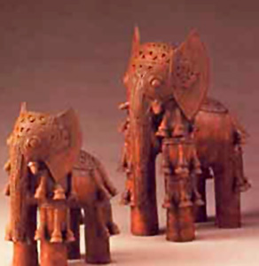
The tribal society of Kanker District is famous for its excellence in making exotic handicrafts with a variety of designs and shapes. These handicrafts include wood-carvings, bell-metal items, terracotta items, bamboo items etc. Kanker District has huge area under forests containing good qualities of woods. Attractive wooden-carving crafts and various types of furniture are being made by the skilled hands of the region. These items attract locals as well as outsiders. Wood craft is one of the most famous, beautiful and unique art forms of the tribes. These wooden crafts are made out of the finest teal wood and white wood. The wooden crafts include models, idols, wall panels and furniture items. These handicrafts are generally exported to different places of the country and it has demand even from foreign countries also. Moreover, another wonderful aspect of the culture of Kanker District is bamboo craft. The tribes are excellent in making handicrafts of bamboo. Bamboo crafts include products like wall hanging, table lamps, table mats, etc.
Economy of Kanker District
Economy of Kanker District is agrarian in character. The land is not plain surface and is mostly covered by forests. So, the farmers firstly cut the trees before the rainy season and plough the land for agriculture. This type of agriculture is called as Marhan or Dippa. After one and two years they prepare a new farm and leave the old one. People divide their farms by constructing small partitions. Rice is the main crop of the area but wheat, sugarcane, chana, Moong and bhutta are the other important crops. People also grow many types of vegetables. A lot of fruits like Mangoes, Bananas, etc. are also produced.
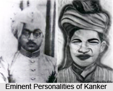
Eminent Personalities of Kanker District
Eminent Personalities of Kanker are the various luminaries who have attained a certain position in certain fields from Sports to Politics to Social activity. They are namely Gen Singh, Ram Prasad Potai, Bhanu Pratap Dev, Pandit Vishnu Prasad Sharma and Tribhuwan Nath Shah Deo. Gen Singh is the identity that Kanker banks upon when it comes to the revolutionary and independent map of Kanker. In ancient India Paralkot was an independent state when the Kanker and Bastar state were under control of British and Marathas at the same time the local abysmal Aboojhmarias were afraid of the fact that their culture may be destroyed due to presence of British and Marathas and as an obvious result these local persons gathered under leadership of Gen Singh as they desires to take revenge from those foreigners. They started to gather in Paralkot for revolution and after that they elected their leader Gen Singh. First they fought against Marathas and British in Paralkot. They started to murder of Marathas and British one by one. Their aim was to establish independent Bastar. Then an English caption Mr. Agnue ordered to abolishment of this revolution and in end they got success on 12 January. Gen Singh was arrested and hanged till death on 20 January1825. Though with his death the revolutionary saga died down yet the contribution of Gen Singh is written in history with golden words.
 Ram Prasad Potai
Ram Prasad Potai was one personality who was famous for his leadership quality and for bringing social awareness. He was born in 1920 in a wealthy family. His childhood name was Pharso. He got his primary education from Kanhar and Kanker. He went to Nagpur for graduation. In 1944 he passed the L.L.B. examination. He was the first one from the tribe of the region who had passed the L.L.B. In his student life he was a very good athlete in high jump and race. He won the hundred of medals in sports. After being advocate he inspired to new generation fro studies. He used his income for the study of poor students. He always supports them financially. In 1944 he met Thakur Pyare Lal Singh a great leader of Chhattisgarh. Then he participated in politics. In 1945 Mr. Jawaharlal Nehru elected him as a member of constitution preparation committee. In 1950 he became a member of parliament. In 1962 he won the election of M.L.A as an independent candidate from Bhanu Pratap pur. He had very good knowledge of Hindi and English. He was affected by the notion of Karl Marx and therefore opposed to British policy as and always. He expired in October 1962.
Pandit Vishnu Prasad Sharma
Pandit Vishnu Prasad Sharma is one of the eminent personalities of Kanker district whose active participation in the Quit India Movement and Indian Struggle for Freedom has left a mark in history. In 1944 he became a member of Indian National Congress. He had been the first elected President of Nagar Palika Kanker (1952 to 1957) and during that time he was youngest President in C.P. and Berar. He had been also president district co-operative bank, Raipur. He was elected in lot of education committees as president like Danteshwari College Jagdalpur Bastar, Gramya Bharti College Kanker, Bharati H.S.School Kanker and Bastar Shiksha Samiti. He also elected the president of Bar Association of Kanker three times. He was honoured as "Vidhi Purush" of kanker Distt. He was Marxist in young age but his life style was totally Gandhian. He was very spokesman, writer, thinker and Freedom fighter. Pt. Vishnu Prasad Sharma declared "Swadheenta Sangram Senani" on 2nd January 2009. He expired after a short illness at Raipur on 18th July 2009. He was cremated on 19th July 2009 at Kanker by "Rajkiya Sammaan" with all Formalities of an Indian Freedom Fighter.
Bhanu Pratap Dev
Bhanu Pratap Dev was another eminent personality who earned a niche for himself when it came to the betterment of humanity and social welfare. After independence Maharajdhiraj Bhanu Pratap Dev participated in the democratic system and was elected as member of the legislative assembly from congress as well as an independent candidate from 1952 to 1957 and thereafter from 1962 to 1967. Maharajdhiraj Bhanu Pratap Dev established a degree college in Kanker in the year 1962 by the name of Gramya Bharti College inviting participation from the public at large and also donated agricultural lands for financial support to the college, in addition to a large number of books and furniture and initially started the college adjacent to the palace premises, the first of its kind in the region benefits of the college are there for all to see as many persons of Kanker and adjoining areas after receiving college education are well placed in service in Chhattisgarh.
Maharajdhiraj was also a gifted photographer and an automobile connoisseur and had a pair of Rolls Royces, in addition to other cars he also patronized sports and club activities of Komal Deo Club Kanker. A man for ahead of his times Maharajdhiraj Bhanu Pratap Dev also started Kanker Bus Service (now Kanker Roadways) and established Mahavir Talkies at Kanker and was also a path breaking member of the governing body of Rajkumar College, Raipur. Maharajdhiraj Bhanu Pratap Deo breathed his last untimely and unfortunately on 14th August 1969 at an early age.
Ram Prasad Potai
Ram Prasad Potai was one personality who was famous for his leadership quality and for bringing social awareness. He was born in 1920 in a wealthy family. His childhood name was Pharso. He got his primary education from Kanhar and Kanker. He went to Nagpur for graduation. In 1944 he passed the L.L.B. examination. He was the first one from the tribe of the region who had passed the L.L.B. In his student life he was a very good athlete in high jump and race. He won the hundred of medals in sports. After being advocate he inspired to new generation fro studies. He used his income for the study of poor students. He always supports them financially. In 1944 he met Thakur Pyare Lal Singh a great leader of Chhattisgarh. Then he participated in politics. In 1945 Mr. Jawaharlal Nehru elected him as a member of constitution preparation committee. In 1950 he became a member of parliament. In 1962 he won the election of M.L.A as an independent candidate from Bhanu Pratap pur. He had very good knowledge of Hindi and English. He was affected by the notion of Karl Marx and therefore opposed to British policy as and always. He expired in October 1962.
Pandit Vishnu Prasad Sharma
Pandit Vishnu Prasad Sharma is one of the eminent personalities of Kanker district whose active participation in the Quit India Movement and Indian Struggle for Freedom has left a mark in history. In 1944 he became a member of Indian National Congress. He had been the first elected President of Nagar Palika Kanker (1952 to 1957) and during that time he was youngest President in C.P. and Berar. He had been also president district co-operative bank, Raipur. He was elected in lot of education committees as president like Danteshwari College Jagdalpur Bastar, Gramya Bharti College Kanker, Bharati H.S.School Kanker and Bastar Shiksha Samiti. He also elected the president of Bar Association of Kanker three times. He was honoured as "Vidhi Purush" of kanker Distt. He was Marxist in young age but his life style was totally Gandhian. He was very spokesman, writer, thinker and Freedom fighter. Pt. Vishnu Prasad Sharma declared "Swadheenta Sangram Senani" on 2nd January 2009. He expired after a short illness at Raipur on 18th July 2009. He was cremated on 19th July 2009 at Kanker by "Rajkiya Sammaan" with all Formalities of an Indian Freedom Fighter.
Bhanu Pratap Dev
Bhanu Pratap Dev was another eminent personality who earned a niche for himself when it came to the betterment of humanity and social welfare. After independence Maharajdhiraj Bhanu Pratap Dev participated in the democratic system and was elected as member of the legislative assembly from congress as well as an independent candidate from 1952 to 1957 and thereafter from 1962 to 1967. Maharajdhiraj Bhanu Pratap Dev established a degree college in Kanker in the year 1962 by the name of Gramya Bharti College inviting participation from the public at large and also donated agricultural lands for financial support to the college, in addition to a large number of books and furniture and initially started the college adjacent to the palace premises, the first of its kind in the region benefits of the college are there for all to see as many persons of Kanker and adjoining areas after receiving college education are well placed in service in Chhattisgarh.
Maharajdhiraj was also a gifted photographer and an automobile connoisseur and had a pair of Rolls Royces, in addition to other cars he also patronized sports and club activities of Komal Deo Club Kanker. A man for ahead of his times Maharajdhiraj Bhanu Pratap Dev also started Kanker Bus Service (now Kanker Roadways) and established Mahavir Talkies at Kanker and was also a path breaking member of the governing body of Rajkumar College, Raipur. Maharajdhiraj Bhanu Pratap Deo breathed his last untimely and unfortunately on 14th August 1969 at an early age.
Tourism in Kanker District
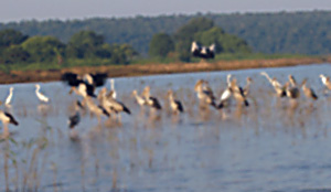
 Tourism in Kanker District consists of various sightseeing options that transform the travelling experience into a memorable one. The scenic beauty of the region enhances the charm of tourism. The travellers can explore the true beauty of this district of Chhattisgarh through its various tourism options. Kanker District attracts travellers from various parts of the world. Here, one can experience enriching nature as well as religious tourism.
Shivani Temple: This temple is situated in Kanker city. There is an amazing statue of Goddess Shivani Maa. In this temple the Navratri festival celebrated grandiosely. The people of all religions have faith in this temple.
Gadiya Mountain: Gadiya Mountain came into light at the time of Kandra dynasty. When the Kandra king Dharma Dev won the Kanker, he declared his capital on Gadhiya Mountain, which is a natural form of a fort. On the mountain there is a tank which never dries. One part of this tank is called as Sonai and the other part of this tank is called as Rupai. Actually Sonai and Rupai were the two daughters of Kandra king Dharma Dev. On the southern part of this tank there is a cave named Churi pagar. The entry of this cave is quite narrow. The exit door of this cave is towards west direction. In the south east part of Gadhiya mountain there is another cave called Jogi cave. The length of this cave is 50 meters. In ancient time a lot of monks lived here for meditation. Interesting, there is a small pond inside this cave. The water of this cave flows on the rock like a water fall. On the bottom of Gadhiya Mountain the Doodh River flows. Shivaratri is celebrated on this mountain. On that day thousand of people climb on the mountain. There is a concrete leader available for climbing the mountain.
Malanjhkudum Waterfall: Towards South direction and 15 kms away form Kanker, there is a small mountain. On this mountain there is a spot named Neele Gondi from where the Doodh River takes its shape. After crossing 10 kms there is a place named as Malanjhkudum from where the river produces three water falls, the heights of these water falls are 10 meters, 15 meters and 9 meters respectively. The slope of this water fall is like a leader. The waves of this water fall are very attractive and challenging. This spot is ideal for exploring.
Charre-Marre Waterfall: This is another beautiful waterfall situated in Kanker District. This water fall is situated 17 kms away from Antagarh a block of Kanker District. There is a place named Charre-Marre on the way from Antagarh to Aamabera. The height of this water fall is 16 metres. The slope of this water fall is of jig jag shape. Without viewing this waterfall travelling experience of any tourist will be considered incomplete.
Kanker Palace
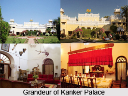 Kanker Palace is an exceptionally beautiful palace located in the district of Kanker. Kanker is a district headquarter town, which was earlier a part of the famous Bastar district of Chhattisgarh. Kanker District is situated in the southern region of Chhattisgarh. Previously Kanker was a part of old Bastar District but in the year 1999 Kanker District got its identity as an independent district. Kanker district has been a popular tourist spot for it`s is scenic beauty, unique tribal villages and for its Royal Kanker Palace along with some fine century-old colonial buildings.
The magnificent and elegant Kanker Palace was constructed as a mansion for the British Agent. Presently the Palace is owned by the Royal family, who trace their ancestors back to the 12th century AD. Still the residential home of the Royal family of the late Maharajadhiraj Udai Pratap Deo, the Kanker Palace has developed a part of it into a hotel for tourists. The palace maintains an informal elegance amid many mementoes of their royal past, since 2002. The palace welcomes its guests who receive a homely hospitality, a royal ambience within a green rural backdrop. Built in the first quarter of the last century, and rebuilt and set in a garden in 1937, Kanker Palace was earlier known as Radhanivas Bagicha. With its Colonial style architecture, the Palace is majestic, elegant, and has an old world charm and ambience.
The splendid architecture of the palace is designed with spacious rooms, exquisitely decorated windows and ventilators, high ceiling and a cosy sitting overlooking the beauty of the surrounding. Set amidst the beautiful landscaped gardens, Royal Palace Kanker has three modern and well-equipped suites. The Palace has a large dining room serving delicious Indian cuisines. Besides, there is a small sitting area on the verandah that offer a breathtaking view of the lush surroundings. The main essence of the palace is the ambience that is preserved here since years. The main essence of the palace is the ambience that is preserved here since years.
The ideal season to visit the Kanker Palace is form October to March, as most of the festival like Narayanpur mandi (February-March), Baster Dussehra (October), Kanker mandi (January) and others are celebrated during this period. One can also visit the weekly haat or the market organized at Bahaigaon and Narayanpur, on Sundays and Thursdays. The backyard of the Palace consists of mango orchard, paddy farm and vegetable garden adding to its natural beauty and charm. Kanker Palace in Kanker is very well connected by rail, road and air.


