 Tourism in Changlang district provides the tourists the splendid natural beauty that will bring the ecstasy in the mind. Changlang district in Arunachal Pradesh has wide range of altitudinal variation ranging from 200 metre to 4500 metre from sea level sprawling over lush evergreen forests overhauling beautiful hills and rivulets over the Patkai Hills Or Purvanchal Ranges, range in the Myanmar border of northeast corner of India. There are some places, which are situated in beautiful locations. These places are very attractive for seasonal visitors. Seasonal visitors are an important factor in economic well being source of income for the local people. While tourists enjoy their visit, the local people can have the chance of getting a good price for their products and their services.
Nature Tourism in Changlang District
Namdapha Tiger Reserve, a true wilderness and enchanting beauty of lush green vegetation, is an impenetrable pristine and virgin forest and covers an area of 1985.23 square kilometres. It has diverse flora and fauna lies in the international border between India and Myanmar (Burma) within Changlang District in the state of Arunachal Pradesh in the northeast India.
Besides these the famous lake called The Lake of no Return in Myanmar side which can be viewed from Pangsau pass is 12 Km away from Nampong in Arunachal Pradesh. During World War II, large numbers of Aircrafts were reported to have perished into this lake. Perhaps, the lake served the Allied Pilots for soft landing into the lake water during return mission when the Aircrafts hit by enemy or out of mechanical snags in the Aircrafts. The Lake of no return, near Pangsau pass international border between India and Myanmar the Pilots had chosen this lake for emergency landing in case of imminent Air crush and therefore, many aircrafts were reported to have crashed in to the lake.
Leisure Tourism in Changlang District
The Changlang district is dotted with a number of pictorial places for the tourist to explore. Foremost of them is the town of Miao. This small town is also the headquarter of the sub-division with the same name. It is situated at bank of River Noa-Dehing. The interesting things to see in Miao are Mini zoo, museum, Tibetan refugee settlement where colourful woollen carpets of various designs are produced, oil drilling at Kharsang and Manabum.
Another place of interest is the Tibetan Refugee Settlement Camp in Miao. Choephelling Tibetan Refugee settlement camp located at a distance of four kilometers from Miao Township under Changlang district is one of the oldest settlements for Tibetan refugees. The camp boasts of producing superior quality carpets, a larger portion of which goes to the global market. The raw materials mainly cotton yarn and wool, procured from Panipat District in Haryana and some quantum from New Zealand, are exotically weaved to international standard and sold in the global market. A beautiful Buddhist monastery in the mid of camp is one of the major attraction for the tourist.
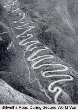
The historic Stilwell`s Road, which was constructed by the Americans during the Second World War from Ledo in Assam, India, which is one of the rail-heads of the Bengal-Assam railway in the valley of the Upper Brahmaputra River during that time, to Burma Road connecting to Kunming, China passes through Lekhapani, Jagun, Jairampur, Nampong and Pangsau pass, India-Burma (Myanmar) border. It winds up the passes of 9000 feet Patkai Range and emerges at Shindbwiyang and then Myitkyina. It crosses the broad bowl of the Upper Chindwin, threads the Hukawng and Mogaung valleys, and goes down to Bhamo and to the Burma Road which connects Kunming, Yunnan province, China.
The recently unearthed large burial-ground with about 1,000 graves of allied soldiers believed to be mostly of Chinese, Kachins, Indian, British and Americans soldiers who died in Second World War is located at Stilwell Road or Ledo Road in the Jairampur-Nampong road, Changlang district.
The hidden cemetery covered with thick jungles midst of the bank of Namchik River and on the Stilwell Road, 6 km from Jairampur town, 39 km from Ledo and 24 Km before reaching Pangsau Pass (Hell Pass), India - Burma (Myanmar) border. The Army has cleared the area and found about 1,000 graves within an area of about three acre. Concrete posts with entrance on three sides enclosed the boundary. The graves are arranged in five lines and several rows. A large grave, possibly a mass burial, is in the centre.


