 Birbhum District is defined with the red soil as Noble Laurate Rabindranath Tagore says about Birbhum "Gram chara oi ranga matir poth....." The architectural trappings of the Stone Age have been unearthed in several parts of the districts. It has been recorded that, Mahavira and Gautam Buddha had navigated the "Rarh" region (Vajjabhumi and Subbhabhumi) of the district. Therefore it can be ascertained that the civilization of Birbhum dates back to the 5th century B.C.
History of Birbhum District
Birbhum district was dominated by different dynasties for centuries. It was once a part of Mauryas and the majestic Guptas. After the extinction of Harshavardhana`s empire, the region was under the Palas till 12th century when the Senas overpowered them. The truly contemporary Pala kings were a great patron of art and culture and initiated the propagation of the Vajrayana cult of Buddhism. Chinese traveler Wang Chung alludes to some of the monasteries he visited in the 7th century. But Buddhism ceased to exist when the Senas rose in ascendancy. As they were the staunch Hindus, only ensured the supremacy of Hinduism. The 13th century witnessed the Muslim uprising in the region & they wiped out all the institutions of the preceding civilization. Minhaj-us Siraj, in his Tabaqat-i-Nasiri mentioned about Lakhnur (a part of Birbhum), as the "thanah" (or headquarter) of the Muslims and an important frontier post. Mythologically the forests of Bajrabhumi (west Birbhum) were the hot spots of the "tantric" activities of the Hindus. The impenetrable, isolated jungles were the ideal place for the sacred Hindu rituals. There was some hermitage in the interior, where the sages performed "tantra sadhana" or "Shakti" Worship. Several temples or "Shakti Peethas" were established by the tantrics (performer of the Shakti rituals) for performing the act of tantra sadhana. Tarapith, Bakreswar, Nalhati, Labhpur, which are now the famous tourist spot once were the notable Shakti peethas. Prior to 1856, Baidyanath Dham (Deogarh) was within the territory of Birbhum. During the reign of the British East India Company, any administrative unit with the name "Birbhum" hardly existed. Till 1787 it was ruled as a part of the Murshidabad administrative unit. The name Birbhum came to be recognized as an administrative unit only after the Santhal rebellion of 1855-56, which was overwhelmed with the martyrdom of Sidhu and Kanu.
Geography of Birbhum District
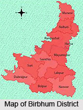
Birbhum District is situated between 23 degree and 32 minutes 30 seconds and 24 degree 35minutes 0 second north latitude and 87 degree 5 minutes 25 seconds and 88 degree 1 minutes 40 seconds east longitudes, and about 4,545 square kilometers in area. The Ajay River forms the southern base whereas the apex of the triangle points to the north. The river forms the boundary between the Birbhum district and Bardhaman district. Jharkhand is located at the northern and the western border of Birbhum and Murshidabad is located at the east. This area lies at the north eastern end of the Chota Nagpur Plateau, as it slopes down and merges with the alluvial plains of the Ganga River. The western portion of the Birbhum District is historically known as Vajjabhumi or Bajrabhumi.
 Demography of Birbhum District
According to the 2011 census of Population in India, Birbhum district has a population of 3,502,387. This gives it a ranking of 84th in India (out of a total of 640). The district has a population density of 771 inhabitants per square kilometers. Its population growth rate over the decade 2001-2011 was 16.15%. Birbhum has a sex ratio of 956 females for every 1000 males and a literacy rate of 70.9%.
Economy of Birbhum District
Birbhum, studded with bushy shrubs offers an undulating landscape. The region is a dual blend of rolling plateau made up of laterite and Gangetic alluvial plains, which is highly conducive for cultivation. Hence the economy of the district is mainly agriculture based and about 3,329.05 square km of land is cultivated. The dry weather of Birbhum district is highly adverse to the agriculture (as excepting the monsoon, the dry weather prevails mainly), therefore the irrigation projects ( Mayurakshi River Project and Hinglow River Project) have been undertaken to induce the agricultural development, which is the backbone of the rural economy. As most of the land is dry and the rivers are only rainfed, the agriculture is supported neither by rain nor by rivers. Hence irrigation is the only way out of this problem. Land with irrigation facilities in 2001-02 was 2,763.9 square kilometers. There are five barrages providing the irrigation facilities. Rice is the major crop, and occupies about of the gross area, is produced in the eastern alluvial plains which are suitable for retaining waters. Apart from rice, legumen, wheat, corn etc are also produced. In recent times, the government has opened up a number of avenues for the expansion of horticulture (E.g.- vegetables, fruits, and flowers, spices, medicinal & aromatic plants), thereby making it an important source of the district`s gross income. As the district is not a rich storehouse of mineral, the industries, which have been developed here, are all agriculture or forest based. The major industries include cotton & silk harvesting & weaving, rice & oilseed milling, lac harvesting, metal ware & pottery manufacture. Other agriculture-based industries are textiles, industries, art & crafts. Shriniketan is a famous dairy & forestry center. In spite of being an important tourist center and a prosperous economy based on agriculture, the standard of living in the district in comparison to the other parts of Bengal is substantially very low. Recently Government has adopted measures and insisted on the educational & economic developments of the district.
So far the Bakreswar Thermal power Station has been established an ample investigation has been made which indicates to the extensive storage of geo-thermal resources here, which extended to the area of about 35 km. Government is about to set up a Mineral Water Plant, Refrigeration Unit, Green House Cultivation GSI & SWID by utilizing the hot water reserve here. Ceramic & other allied industries are under construction by exploiting the enormous deposit of quartz & feldspar. Hydrological survey in the district has reported that the suitable exploitation of the groundwater structure & the optimum use of that will preserve the groundwater at the desired level, thereby supplement the irrigation process of the district.
Culture of Birbhum District
Birbhum District was inhabited by a number of people belonging from different civilization, which makes the land as the blend of both indigenous & alien culture. The diverse culture of Birbhum district from the prehistoric times inspires the poet and its rural society was the focus for the poets of Vaishnava & Shakta Padavali. However it was the folk culture, which gets prominence in the post-independence period. The folk culture or rather the native culture of Birbhum district was specially augmented by the contribution of the bauls, their philosophy & their music. The concept of Baulism emerged as a religiously liberal philosophy & lifestyle which conforms to the ideals of Sahajyan movement, a refined form of Vajrayan movement, also supplemented by the influence of Vaishnavism & Sufism. The bauls who earn their living by singing & collecting alms, accommodate people from all castes & creed. "Baulism" is the true replica of the mixed culture of the land and the truly modern bauls upheld a broader yet liberal perspective of life & culture.
 Tagore was immensely influenced by the bauls and some of his works are endowed with the "baulian" philosophy. Birbhum is the hub of Bengal`s folk culture. In addition of being a confluence of Vaishnav, Shakta & Shaiva culture, Birbhum villages also observes the worship of "gramadevata" or the god of village popularly known as the "Dharma Thakur", symbolized by a stone& mainly the tribals like bagdi, dome, hari, bauri worship "Dharma Thakur." The folks of Birbhum are the clear representation of the spirit of rural Bengal.
Education in Birbhum District
Government also aided the primary and high schools over here and at the same time the establishment of the Birbhum Institute of Engineering & Technology, a renowned Institute of vocational training has added a feather to the cap of the district`s heritage. However Birbhum district is recently acknowledged as a magnificent seat of the academics.
Cottage Industry of Birbhum District
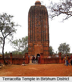
Birbhum is the heart of cottage industries in Bengal. "Amar Kutir", a nonprofit rural organization is a brand name in the vicinity of cottage industries. However a major part of cottage industry include textile -especially cotton and locally harvested tussar silk, jute works, batik, kantha stitch, macrame (weaving by knotting threads), leather, pottery and terracotta, solapith, woodcarving, bamboo and cane craft, metal works and various tribal crafts.
Some low grade minerals, like coal, iron ore of inferior quality and granite are mined in the western section. Mohammed Bazar block contain china clay & laterite mines. There are laterite & china clay industries in Panchami villge which contribute to the district`s economy to some extent. Bakreswar thermal Power station is the only heavy industry of the region which accounts for the power supply of the local region and also the neighboring parts.
Tourism in Birbhum District
"The land of the red soil", Birbhum is also quoted as "a land of brave"(land- "bhumi"; brave-"bhumi") because the land was dominated by several brave kings since its advent . Remnants of those civilizations once colonized in the region, adds profound historical importance to the immense worth of the land. The district is mainly famous as a heritage place. Bolpur- Shantiniketan, Nannor, Joydev-Kenduli, Amar Kutir etc. are the principal sites of attraction here.
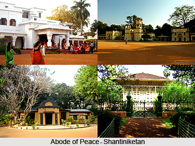
By far the most famous tourist spot here, and in fact a top draw in all of West Bengal, is Shantiniketan. It is the place where Rabindranath Tagore lived and composed some of his most famous literary pieces. It is now a University town, and the famous Visva- Bharati University is also found located here. A number of seasonal festivals are celebrated here with great pomp and vigour. Apart from this, places of pilgrimage, called piths are also found in the district. The piths are said to be the places where one of the many dismembered parts of Sati fell. These piths in the Birbhum district are located at Tarapith, Bakreshwar, Kaklitala, Labpur etc.


