 Sabari River
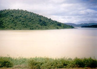
Sabari River, a major tributary of the Godavari, holds significant ecological and economic importance in the states of Odisha, Chhattisgarh, and Andhra Pradesh in India. Originating from the Sinkaram hill ranges in Odisha, this river meanders through diverse landscapes, forming the boundary between states and joining the mighty Godavari. With its tributaries, such as Sileru River, and hydroelectric power projects, Sabari River contributes to clean energy generation and irrigation facilities, benefiting agriculture and the local economy. Its rich biodiversity and occasional floods add to its allure and challenges, making it a lifeline in the region`s ecological and economic tapestry.
Origin and Course of Sabari River
Sabari River originates from the Sinkaram hill ranges, situated at an elevation of 1374 meters above mean sea level (MSL), in the state of Odisha. Also known as Kolab River in Odisha, it traverses a distance of approximately 200 kilometers, forming the boundary between Odisha and Chhattisgarh. The river then enters Andhra Pradesh and eventually merges with the Godavari near Kunavaram.
Tributaries of Sabari River
Sileru River, also known as Machkund in its upper reaches, is one of the major tributaries of Sabari River. It joins Sabari River at the tri-junction boundary point of Andhra Pradesh, Chhattisgarh, and Odisha. The Sileru River has immense hydroelectricity generation potential, which has been harnessed through projects.
Ecological Significance of Sabari River
The Sabari River basin receives an average annual rainfall of nearly 1250 mm. This abundant rainfall contributes to the ecological significance of the river by maintaining a diverse range of flora and fauna in the region. The river and its surrounding areas serve as a habitat for various species of plants, animals, and birds, making it an ecologically important region. The river supports a rich aquatic ecosystem, providing sustenance to a variety of aquatic organisms.
Economic Significance of Sabari River
Sabari River holds immense economical importance in the regions it flows through. This makes the river an important source of livelihood to millions in three Indian states.
Irrigation:
The Upper Kolab project, a major dam located in Odisha across the Sabari River, plays a pivotal role in providing water for irrigation. This ensures the availability of water for agricultural activities, benefiting farmers in the region and contributing to the agricultural economy.
Hydroelectric Power Generation
: The Sabari River and its tributaries, such as Sileru River, support several hydroelectric power generation projects like Machkund, Balimela, upper Sileru, Donkarayi, and lower Sileru. These hydro power projects provide a significant source of clean and renewable energy for the region. The generated electricity not only caters to the local needs but also contributes to the overall power supply of the states.
Transportation:
While the Sabari River brings occasional challenges in the form of floods, it also serves as a means of transportation. The river facilitates the movement of goods and people through boat transportation in certain areas, providing a cost-effective and efficient mode of travel.
Floods and Challenges of Sabari River
The course of Sabari River encounters heavy rainfall, leading to periodic flooding. During flood times, the water level in the river rises significantly, reaching from 21 feet to 28 feet. This poses challenges to road transportation, particularly between Chintoor and Vararamachandrapuram mandal. The floods often cause devastation in low-lying Chintoor villages, washing them away and necessitating the implementation of flood management measures.
Sabari River, with its origin in the Eastern Ghats and its journey through Odisha, Chhattisgarh, and Andhra Pradesh, plays a crucial role in the ecological and economic landscape of the region. Its tributaries and the hydroelectric power projects associated with them contribute to the generation of clean energy, while irrigation facilities support agriculture and food production. The river`s rich biodiversity and natural beauty make it an ecological hotspot. However, the challenges posed by periodic floods call for effective flood management measures. The sustainable management of Sabari River is essential to ensure the well-being of both the environment and the communities that rely on it.


