 Nilkantha peak is an amazing Himalayan peak nestled in the state of Uttarakhand which is often referred to as the "Land of the Gods". The peak is also spelled as Nilkanth and Neelkanth. Nilkantha is one of the major peaks of the Garhwal division of the Himalayas. Frank Smythe, the British mountaineer, author, photographer and botanist, described the peak as "second only to Siniolchu in Himalayan beauty." Nilkantha is build with steep ridges and faces, which resisted several climbing attempts, beginning with Frank Smythe in 1937. On the basis of peakery data, Nilkantha peak ranks as the 18th highest mountain in India. The peak was first scaled in the year 1961, by an expedition led by Col. Narinder Kumar.
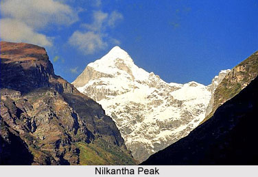
Location of Nilkantha Peak
The peak is located in the Garhwal division of the Uttarakhand state of India. It is situated at an altitude of 6596 metres (21,640 feet) above mean sea level. It towers dramatically over the valley of the Alaknanda River and rises 3,474 metres above the Hindu sacred town of Badrinath.
Attractions of Nilkantha Peak
Nilkantha Peak is surrounded by various beautiful glaciers and other peaks. The Satopanth Glacier lies in the northwest direction of Nilkantha below 2,500 metres (8,200 feet) face of the peak. The Panpatia Glacier lies in the southwest of Nilkantha and provides water to the Khirao Ganga. The Khirao Ganga stream flows under the south side of the peak. In the western direction of the peak lies the famous Gangotri Glacier along with its associated peak. Across the Alaknanda valley lie the Kamet and Nanda Devi mountain peaks.
Mythological Story of Nilkantha Peak
As per the mythological story, there was no mountain on the spot where Nilkantha stands in the present day. It is believed that an adage route passed between Kedarnath and Badrinath. The worshiper of the two temples worshiped them one day and after that day it continued for a long time. But one fine day, due to some sins of the worshipper, Lord Shiva became displeased with him. As a result, he stood blocking the way as huge Sky-Kissing Mountain which is said to be the modern Nilkantha.