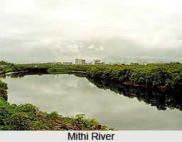
 Mithi River is located in Salsette Island on which the Mumbai city is situated. It is also known as the Mahim River. The river is actually the merging of the tail water that is discharged from the Powai and Vihar Lake. It is a seasonal river, which feeds on the monsoons.
Geography of Mithi River
The river rises from the valley near the Sanjay Gandhi National Park at Powai and merges with the Arabian Sea at Mahim Creek. During its course, the river flows through residential and industrial complexes of Powai, Saki Naka, Kurla, Kalina, Vakola, Bandra-Kurla complex, Dharavi and Mahim for fifteen kilometres. The river is narrow in its initial course, which is nearly ten metres in width, but it widens gradually and is wide at the Bandra Kurla complex. The river is fourteen kilometres in length. The average width of the river in the upper reaches is 5 m. It has been widened to 25 m in the middle reaches and up to 70 m in the lower reaches after the 26 July 2005 deluge.
Ecology of Mithi River
The Mahim bay area where the Mithi River merges with the Arabian Sea is a bird sanctuary, which is called Salim Ali Bird Sanctuary. Many migratory birds visit the area. A dam has been constructed across this river along the upstream side of Vihar Lake. The river is a natural drainage channel, which carries the surplus waters during the monsoon.
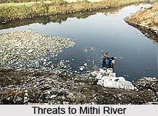 Threats to Mithi River
There are many threats to the water of Mithi. The dumping of raw sewage, industrial waste and municipal waste into the river highly pollutes the water. To make it worse, the barrel cleaners, scrap dealers and others dump sludge oil, effluent and garbage in the river. The water with mixture of sewage and industrial waste is a threat to marine life.
Efforts to Save Mithi River
Many young entrepreneurs in and around Mumbai are putting effort to create awareness and save the river. In the year 2009, environmentalist and Magsaysay Award winner, Rajendra Singh lead a yatra, of a group of environmentalist and NGOs, through Mumbai city along the endangered Mithi River to emphasize its problems.