
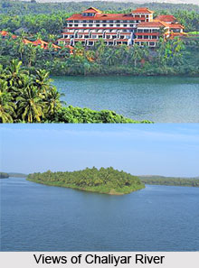
 Chaliyar River is a river that flows in the Kerala state of India. It is the fourth longest river in Kerala with a length of 169 km. It is also known as Beypore River. The specialty of this river is that it does not get dried up in the drought season. The river was extensively used for business purposes in the 19th-20th century. Presently, the bank of Chaliyar shelters various towns and villages namely Nilambur, Edavanna, Areekode, Kizhuparamba, Cheruvadi, Mavoor, Peruvayal, Feroke and Beypore. A few kilometers away from the Kondotty Hill, the Kavanakallu Regulator cum bridge is constructed over the Chaliyar River. And few kilometers from Nilambur, beyond the Chaliyar there is Valamthode.
Etymology of Chaliyar River
It got names like Chaliyar and Beypore River as it meets the Lakshadweep Sea at an `azhi` (estuary), the southern part of which is known as Chaliyam and northern part as Beypore. However, it is more popular as Chaliyar.
Origin and Flowing of Chaliyar River
It originates in the Western Ghats range at Elambalari Hills in the Wayanad Plateau of Kerala. From there, it flows through Malappuram district for most of its length. Then for around 17 km, it forms the boundary between Malappuram district and Kozhikode district. Next, it enters the city of Kozhikode for its final 10 km journey. It finally empties into the Lakshadweep Sea.
Tributaries of Chaliyar River
The drainage system of Chaliyar River is constituted by six streams including Chaliyarpuzha, Punnapuzha, Kanjirapuzha, Karimpuzha, Iruvahnipuzha and Cherupuzha. The other tributaries of this river are Kurumanpuzha, Pandipuzha, Maradipuzha, Kuthirapuzha and Karakkodupuzha. Most of these rivers have their origin in the Nilgiri hills in the east and Wayanad hills in the north.
Economical Significance of Chaliyar River
During the 19th -20th century, this river was extensively used for trade purposes. It was used as a waterway for carrying timber from the forest areas in and around Nilambur to the various mills in Kallai of Calicut city. At that time, Calicut city was one of the most important timber business centers in the world. However, towards the second half of the 20th century, the activity came down drastically as tree felling was strictly controlled in order to stop deforestation.









