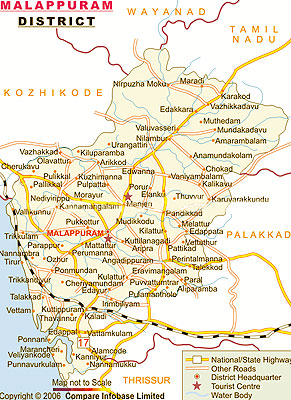
About Mallapuram District
 Mallapuram district was born on 16th June 1969. It is situated on the Calicut - Madras road that is at 12 km. southwest of Manjeri and 52 km. southwest of Calicut. Mallapuram is the head quarters of the district. In earlier times, Mallapuram was the headquarters of European and British troops and later it became the headquarters of the Malabar Special Police, which is known, as abbreviation is M.S.P.
This place has still the ruins of an ancient fort built by Tipu Sultan. Mallapuram was also the scene of the Malabar rebellion of 1921, which was suppressed by the Malabar Special Police. In 1957 and 1969 large-scale changes in the territorial jurisdiction of this tract took place. On 1st January 1957, Tirur taluk was newly formed taking portions of Ernad and Ponnani taluks. Another portion of Ponnani taluk was transferred to the newly formed Chavakkad taluk, while the residuary portion was known as Ponnani taluk.
Perinthalmanna was a new taluk formed out of the former Valluvanad taluk. Of these, Ernad and Tirur continued under Kozhikode district and Perinthalmanna as well as Ponnani under the Palakkad district. The new district of Mallapuram was formed with four taluks, Ernad, Perinthalmanna, Tirur and Ponnani, four statutory towns, fourteen developmental blocks and ninety-five panchayats. Two more taluks namely Tirurangadi and Nilambur were formed later by diverging Tirur and Ernad taluk.
At present Mallapuram District consists of 2 Revenue Divisions, 6 Taluks, 135 Villages, 14 blocks, 5 Muncipalities and 100 panchayats.
History of Mallapuram District
 The historical legacy of the Malappuram district is one of a rich culture and tradition. Malappuram district took its birth on 16-6-1969. It is situated on the Calicut - Chennai road, 12 km. south - west of Manjeri and 52 km. south - west of Calicut. Malappuram is the head quarters of the district. In the early days, Malappuram was the headquarters of the European and British troops. Before Indian independence in 1947, Malappuram was a part of Malabar District in the Madras Presidency of British India. The area covered by the present district was administered as a part of Kozhikode, Ernad, Valluvanad and Ponnani taluks. Malabar District remained part of Chennai state for some time after Indian independence.
The district has long been a part of Indian history, by means of the support it gave in terms of participation in the Indian national movement. Malappuram has been a part of the Khilafat movement as well as the Moplah rebellion. The latter was a protest by the Muslims of Malabar against the abolition of the Islamic Caliphate in Turkey by the British. Malappuram was also the scene of the Malabar rebellion of 1921 which was suppressed by the Malabar Special Police (M.S.P)
On 1 November 1956, Malabar District was merged with Travancore-Cochin to form the state of Kerala. Large-scale changes in the territorial jurisdiction of this tract took place in 1957 and 1969. On 1 January 1957, Tirur taluk was newly formed, taking portions of Ernad and Ponnani taluks. Another portion of Ponnani taluk was transferred to the newly formed Chavakkad taluk. The residuary portion constitutes present-day Ponnani taluk. Perinthalmanna was a new taluk formed out of the erstwhile Valluvanad taluk. Of these, Ernad and Tirur continued under Kozhikode District and Perinthalmanna as well as Ponnani under the Palakkad District.
The new district of Malappuram was formed with four taluks, Ernad, Perinthalmanna, Tirur and Ponnani, four statutory towns, fourteen developmental blocks and 95 panchayats. Two more taluks, namely Tirurangadi and Nilambur, were formed later by bifurcating Tirur and Ernad taluks. At present Malappuram District consists of 2 Revenue Divisions, 6 Taluks, 135 Villages, 14 blocks, 5 Municipalities and 100 Panchayats.
Geography of Mallapuram District
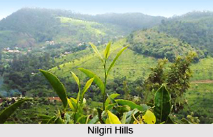
Mallapuram is a hilly terraced region. The innumerable streams that wander these hills reach the coconut fringed and picturesque seacoast. In many places, these streams are linked with backwaters, which facilitate a network of inland waterways. The midland region is fertile with thick coconut groves. These are the source of innumerable streams and rivers.
The names and height of some of the hills are as follows:
Vavil or Vayutmala is 2339.73 m, Vellarimala is 2335.58 m, Chakkumala hills are 600.46 m, Urothmala is 477.60 m and Pandalur hills are 610.20 m.
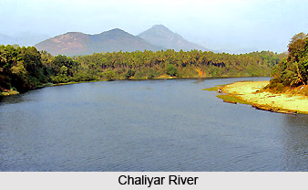
Important rivers :There are some important rivers that flow through the Mallapuram district. These are as follows:
Chaliyar or Beypore River: Chaliyar or Beyore River is one of the major rivers of the State, which takes its origin from Elembileri hills of Waynad taluk.
Kadalundi River: Kadalundi River is also known as Karimpuzha or Oravanpurampuzha River. It originates from the Silent Valley reserve forests at an elevation of 1219 metres above the sea level. This river forms a part of the west coast navigation system from Palathigal in the south to Mannur in the north. It has a length of 130 metres with a catchment area of 1114 sq. km.
Purapparamba River: Purapparamba is a small river whose length is 8 Km. It originates from the tail end of Purapparamba scratch. It flows in the western direction and crosses the Madras - Mangalore railway line between Tanur and Parappanangadi station. This river is connected with other rivers in the districts by canoli canal.
Tirur River: Tirur River whose length is 48 Km. raises from the Athvanad village of Tirur taluk, flows South-west up to Thiruvnavaya and flows upto Elamkulam in the north western direction. Then it turns southwest and finally joins Bharathapuzha to reach the sea near Ponnani. This river is navigable and motorboat can play between Tirur and Ponnani. It also forms part of west coast water transport system.
Bharathapuzha: Bharathapuzha is also known as Nila nadi or Ponnani River. It has its source in the Anamalai hills at about 982 metres above the main sea level. After flowing through Pollachi taluk of Coimbatore District, it enters the Palakkad district of Kerala state. During its course, it forms the boundary between Palakkad and Trissur Districts.
Sea - Coast: Sea - Coast of the district extends to 70 Km with a minor port at Ponnani. The Port is tidal since it is very shallow; most of the vessels have to be anchored out in the sea. There is large number of fishing centers on this coastline.
Backwater and Canals: There are no major backwaters in this district. The Veliyancode Lake, which is situated at 5 km, South-east of Ponnani, opens to the sea at Veliyancode. A regulator is installed there to prevent the influence of salt water in to the lake. Some of the other minor backwaters of ponnani taluk can be mentioned as Maniyar kayal, Valancherry Kayal and Maravancherry kayal.
Different departments of Mallapuram district
 Revenue: Mallapuram district is consisting of two Revenue Divisions, six Taluks, and 135 villages. Some of the important functions of revenue department are revenue recovery, building tax, assignment of Government Land, assignment of surplus land, lease, citizenship registration, explosive license and magisterial powers, election, etc.
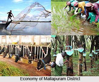
Agricultural activities: The Agriculture Department in Malappuram District is taking sincere effort for carving out a dynamic and vibrant agriculture sector. This is responsive to the needs of local farming community.India`s first food technology park is at Kakkancherry in Mallapuram.
The role and responsibility of Krishi Bhavan and the basic contact point of the farming community is very significant in planning, formulation and execution of viable and need based programme. Krishi Bhavan also acts as an effective transfer of technology agents in the agricultural sector. The following are some of the important schemes implemented by the department: State sector scheme for rice and paddy, Central sector scheme for coconut, intensive vegetable development programme, etc.
Fisheries: The Mallapuram district has 70 km of seacoast. It extends from Kadalundi Nagaram in the north to Palappetty in the South. The coastal belt is in many places. The main fishing centers are at Ponnani, Koottayi, Parappanangadi, and Tanur. Out of these centers Ponnani is a major fisheries port with about 350 mechanized boats. High sea fish catching operations are centered in Ponnani and Parappanangadi. There are Fisheries guide lights, at Ponnani and Tanur to help night fishing.
There are various schemes to provide fishing equipments, houses, latrines and other amenities to fishermen. There are also educational assistance schemes, financial assistance for the benefits of fishermen during off-season. A Fish Farmer Development Agency or FFDA is there to promote inland fishing.
Animal husbandry: The functioning of Animal Husbandry can be classified into 7 groups. Viz. artificial insemination, treatment facilities, remedial measures for resisting diseases, schemes, production centers, is some of them.
Health services: A good network of health care units are functioning under the Government Sector. Modern medicines, Ayurveda and Homeopathy services are also available.
Co-operatives: The district has a good network of Co-Operative societies. All types of Co-operative activities ranging from ration shops to hospitals are undertaken under Co-operatives.
Scheduled caste development: The District has a scheduled caste population of 25,573. Some of the main communities are Pulaya, Paraya, Kanakka Panan, Mannaan, Perumannaan, Kalladi, Cheruma etc. In some of the developmental programmes Education is given priority for the Scheduled Castes.
The scheduled caste development department undertake various social welfare measures like house construction, providing land and house to the landless and houseless people, thatching and filling grants, sanitation latrine construction, lump sum grant and stipend to SC students, etc. This department also gives educational Assistance to Other Backward Communities, Other Eligible Communities, and financially backward students of forward communities.
National informatics center: The organizational structure of NIC comprehends its Headquarters at Delhi; Regional centre at Pune, Bhubaneshwar and Hyderabad; State units in all the state Capitals and Union Territory Headquarters; and Offices in over all Districts of the country, respectively.
 Mass communication: : Malayala Manorama published from Malappuram, Mathrubhumi published from Kottakkal and Madyamam published from Perinthalmanna are the three newspapers published from the district. The evening daily Prehalika, is published from Tirur. A few periodicals, monthlies, fortnightlies and weeklies, which are devoted to this religion and culture, are also published. Since 1981 a capsule cultural monthly magazine Innu is being published from Malappuram. All the important daily newspapers published from other districts, have wide circulation in Malappuram district.
Education: : The Mallapuram district has achieved tremendous progress in the filed of education during the last decade. Great development has been made in the field of female education. There are various numbers of schools, colleges, B.Ed centers, polytechniques, teaching training institute, engineering colleges, oriental title colleges, etc present in this district. The Calicut University present in Tenhippalam in Malappuram district was established in 1968.Malapuram is India`s first fully e-literate district.World`s only teak meuseum is at Nilambur in Mallapuram.
Transportation of Mallapuram District
According to available sources, this district has 4086 km of roads, which connects district headquarters, taluk headquarters, towns and important centers. The State highway from Kozhikode to Guddalore passes through Kondotty, Nediyiruppu, Narukkara, Manjeri, Trikkalangod, Karakurrssi, Edavanna, Nilambur and Edakkara villages of Ernad taluk. The Calicut-Madras road touches Malappuram, Angadippuram and Perinthalmanna before it leaves for Mannarghat, Another road connects Perinthalmanna with Shoranur via Pattambi. The Trichur-Kozhikode road, which forms part of National Highway, passes through Tirurangadi and Thenjhipalam and joins the Madras-Kozhikode road at Ramanattukara.
Railway : On 12th March 1861 the Madras Railway Company first opened the Railway line connecting Kadalundi and Tirur for traffic. This was extended to Kuttippuram on 1st May 1861. The Shoranur-Nilambur section was opened for traffic in February 1927. The total length of railways in this district is about 91 km. Angadippuram, Nilambur, Kuttippuram, Tirunavaya, Tirur, Tanur and Parappanangadi are the important stations of which Tirur and Tanur are important fish exporting stations.
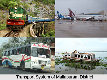 Airport : The Calicut airport is one of the most beautifully designed airports in India, which is situated at Karippur in Malappuram District. It is 26 Km away from Malappuram and 28 Km away from Kozhikode. It has a runway of 6000 x I 50 feet with night landing facilities. A huge project of extending the runway by 3000 feet with a view to facilitate landing of airbuses is under completion. Regular flights to Bombay, Bangalore, Madura, Coimbatore, Madras and gulf countries are operated presently. From 2002 onwards Calicut airport in Malappuram district has been recognised as the embarkation point for Haj pilgrims.
Helipad : A well-developed helipad at Kottakunnu is available for safe landing of all types of helicopters in all seasons through out the year. It is placed at 12 Nautical miles from Calicut VOR.
Port : Ponnani is the only port at the mouth of the river Bharathapuzha that is tidal and very shallow. The ships have to anchor far off in the sea and traffic of this port will have to be improved. The important places connected by waterways are Ponnani, Tirur and Tirurangadi. They are mainly used for transporting timber.


