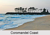
 Coromandel Coast is the southeastern coast region of the Indian Subcontinent. It is nestled between the Eastern Ghats and the Bay of Bengal of the Indian Ocean. The coast stretches from the Point Calimere (Kodikkarai), near the delta of the Kaveri River to the mouth of the Krishna River. Tamil Nadu, Andhra Pradesh and the union territory of Pondicherry share the Coromandel Coast.
Etymology of Coromandel Coast
The name Coromandel Coast stems from the Tamil phrase "Chola Mandalam". It means the region was ruled by the Cholas, an ancient dynasty of southern India.
History of Coromandel Coast
The Coromandel Coast was the seat of rivalry among European powers in the seventeenth and eighteenth centuries. The French established themselves at Pondicherry, Karaikal and Nizampatnam; the Danish at Dansborg at Tranquebar; the Dutch at Pulicat and Sadras and the British at Fort St George (Chennai) and Masulipatnam. Finally, it was the British who emerged victorious. However, the French retained a tiny portion of the coast at Pondicherry (now known as Puducherry) and Karailal till 1954. Many Chinese exports like Chinese lacquer, boxes, screens and chests were consolidated at the Coromandel port in the eighteenth century and they came to be known as "Coromandel" goods. It was the tsunami of December 26, 2004 which devastated the Coromandel Coast killing and sweeping away many coastal communities.
Geography of Coromandel Coast
Generally, the Coast is low and interrupted by the deltas of several large rivers, including the Kaveri (Cauvery), Palar, Penner and Krishna, which rise in the highlands of the Western Ghats and flow across the Deccan Plateau to drain into the Bay of Bengal. The rivers deposit alluvial soil and create alluvial plains which favour cultivation.
Climate of Coromandel Coast
The Coromandel Coast falls in the rain shadow of the Western Ghats. On an average the region receives 800 millimeter per year, most of which falls between October and December. This coast of Bay of Bengal is hit by cyclones and hurricanes every year between October to January.
Flora and Fauna of Coromandel Coast
This coast is the abode of the East Deccan dry evergreen forests. The trees of the East Deccan dry evergreen forests have leathery leaves throughout the year unlike most other tropical dry forests of India where the trees lose their leaves during the dry season. The Coromandel Coast also has many mangrove forests along the low lying coast and river deltas and several important lowlands like Kaliveli Lake and Pulicat Lake that are the home of several migrating and resident birds.
Economical Significance of Coromandel Coast
The coast is known for its ports and harbours. They are Pulicat, Chennai, Sadras, Pondicherry, Karaikal, Cuddalore, Tranquebar, Nagore and Nagapattinam. The region is also rich in natural and mineral resources. The Golconda and the Kolar gold mines are located in this belt.


