 Buxar District is an administrative district of Bihar. The district has its headquarters at Buxar. The total area occupied by the district is 1624 sq km. Buxar is located at 25 degree 34 minutes north and 85 degree 58 minutes east. It has an average elevation of 56 metres (183 feet) above the sea level. The rivers flowing through the district are Ganga River and Karmnasha River. The present district of Buxar consists of areas under Buxar Sadar and Dumraon Sub-Division of the old Bhojpur district and came in existence in the year 1991. Buxar District is bounded on the north by Ballia district of Uttar Pradesh, on the south by Rohtas district, on the west by Ghazipur district and Ballia districts, and on the east by Bhojpur district.
History of Buxar District
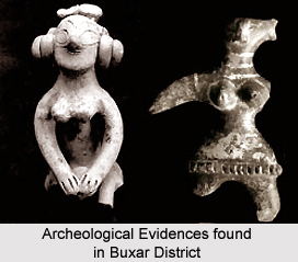
Buxar District has close linkage with that of its parent district Bhojpur and has an old and an interesting history. Buxar is famous since the epic period for being the seats of eminent saints, battlefield of Gods and Demons as per Indian Puranas and a combat zone between foreign invasion and compatriots in modern history. The remains from archaeological excavations have established the link of Buxar with ancient civilizations of Mohenjodaro and Harappa. History of Buxar dates back even prior to the period of Ramayana. During the Mughal period, the historic battle between Humayun and Sher Shah Suri was fought at Chousa (Battle of Chausa) in 1539 AD.
Geography of Buxar District
Geography of Buxar District is characterized by a moderate climate. The hot weather begins from the middle of March when hot westerly winds begin to blow during the day. The months of April and May are extremely hot; normally the monsoon sets in by the third week of June and continues till the end of September. The cold weather begins from November and lasts till the beginning of March, January is the coldest month when the temperature comes down as low as 10 degree Celsius. The district experiences maximum rain during the months of July and August. Due to deforestation, the forest area of this district is very thin. Firewood is the most important among the forest products. The mineral resources of this district are negligible.
The important wholesale markets in the district are at Buxar and Dumraon. Further, there are different types of small scale and cottage industries located in Buxar District.


