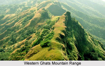
Western Ghats mountain ranges constitute the beautiful array of mountains along the western coast of India that separates the Deccan Plateau from a narrow coastal strip along the Arabian Sea. It is a virtual mountain range as it is a fractured extension of the Deccan Plateau possibly formed during the break up of the super continent Gondwana. This particular mountain range starts from the southern part of the Tapti River near the border area of the states of Gujarat and Maharashtra. Western Ghats mountain ranges cover a length of around 1600 km running through the states of Maharashtra, Goa, Karnataka, Tamil Nadu and Kerala finally culminating at Kanyakumari District, in the southern-most tip of the Indian peninsula. Covering an area of around 60,000 sq kilometres they form the catchments area for a large number of rivers draining almost 40 percent of the Indian sub-continent.
Mountains, Gaps and Passes of Western Ghats
Western Ghats have an average elevation of 1200 metres. However, in certain places they rise abruptly to a height of over 2440 metres. The Western Ghats of Maharashtra, extending from the Satpura Mountain Range to the north, travels towards the south past Goa to Karnataka. The principal hill range of the segment is the Sayadhri range. The two main peaks here are Kalsubai, having a height of 1646 metres and Salher with a height of 1567 metres. There are a number of gaps and passes in the Western Ghats, notable among them being the Thal Ghat and the Bhor Ghat. The southern part of the Western Ghats mountain ranges harbour the Nilgiri hills, which serve as the meeting point of the Western and Eastern Ghats. The Nilgiris show a steep rise from the plains and enclose between them the Karnataka Plateau.
 There are two highest peaks in the Nilgiri Hills Dodabetta, having a height of 2637 metres and Makurti, having a height of 2554 metres. To the south of the Nilgiri Hills is located the Palghat gap, extending from the east to the west of the mountain ranges. With a width of 24 km, the Palghat gap is an easy passageway across the Western Ghats. To the south of the Nilgiris are the Anaimalai, Cardamom and Palni hills. The Anaimudi is the highest peak in Peninsular India. It is situated in the Anaimalai hills and has a height of 2695 metres. The narrow coastal plain between the Western Ghats and the Arabian Sea is known as the Konkan Coast in the north and the Malabar Coast in the south. The largest city amidst these mountains is Pune.
Climate and Rainfall in the Western Ghats Mountain Ranges
The lower parts of the Western Ghats mountain ranges record humid and tropical type of climate. The elevated regions (around 1,500 metres and above in the north and 2,000 metres and above in the south) have a more moderate climate. Mean temperature varies from 24 degree Celsius in the north to 20 degree Celsius in the south. However, the Western Ghats have a climate largely modified by the winds as they play a significant role in the seasonal cycle. In the summer season, they are responsible for ushering the monsoons while in the winter season these winds offer a calming effect. During the monsoon period that is in between June and September, the path of heavy, eastward-moving rain bearing clouds is interrupted by the Western Ghats. This results in more rain on the windward side, an average of near about 3,000 mm to 4,000 mm with occasional extremes of 9,000 mm. On the other hand the eastern region of the Western Ghats, which is the rain-shadow region, records an average of 1000 mm. The Coromandel Coast falls in the rain shadow of the Western Ghats, and receives less rainfall during the summer southwest monsoon, which contributes heavily to rainfall in the rest of the country.
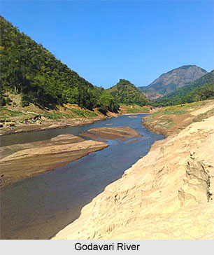
Rivers in Western Ghats Mountain Ranges
The drainage system of the Western Ghats constitutes the perennial rivers of peninsular India. Westward flowing rivers like the Godavari River, Krishna River, and Kaveri River drain into the Arabian Sea. Moreover, rivers like the Zuari River, Mandovi River and Periyar River that flow eastwards drain into the Bay of Bengal. Some of these rivers feed the backwaters of Maharashtra and Kerala. The Chittar River, Kabini River, Kallayi River, Bhima River, Malaprabha River, Kundali River, Pachaiyar River, Manimuthar River, Pennar River, and the Tambaraparani River are other relatively smaller rivers. Prominent reservoirs in the Western Ghats comprise the Koyna Dam in Maharashtra, the Parambikulam Dam in Kerala, and the Linganmakki Dam in Karnataka.
 The Western Ghats is considered as one of the most cherished ecological destinations. The chief ecosystems of the Western Ghats include the tropical wet evergreen forests in Amboli and Radhanagari, the montane evergreen forests in Mahabaleshwar and Bhimashanker, the moist deciduous forests in Mulsi and the scrub forests in Mundunthurai. The vegetation all along the Western Ghats mountain ranges offers much variety ranging from grassland, scrub jungles along the lower altitudes, dry and moist deciduous forests, to semi-evergreen and evergreen forests. There are two major centres of multiplicity, the Agashyamalai hills and the Silent Valley. The many-sided landscape and the heavy rainfall have made certain areas inaccessible and have helped in preserving the diversity of the region. A large range of flowering plant species of the country are found in this region. Of the 450 plants found in this region, 40 percent are prominent because they have been totally acclimatised to the climate.
The wildlife provides an equal diversity. The Nilgiri biodiversity reserve, the only biodiversity reserve in the Western Ghats, promotes conservation of endemic and endangered species. In the Western Ghats, some national parks have also been built. The Borivali National Park and the Nagarhole National Park harbours many kinds of birds while the Bandipur National Park is home to many tigers, leopards, sloth bears, barking deer and mouse deer. Anamalai Wildlife Sanctuary located in Tamil Nadu has evergreen forests as well as temperate grasslands. Animals that are mostly found here include Nilgiri langur, rare lion-tailed macaque, spotted deer, and the giant squirrel and birds like hornbills, fairy bluebirds and racket tailed drongos. The famous Periyar National Park in Kerala harbours a large number of elephants, gaur, lion-tailed macaque and a variety of birds.
However, as is the case for many ecosystems, modernisation has taken its toll on this region. This has led to the extinction of many species and more are in danger of becoming extinct.
Western Ghats Mountain Range in India
Western Ghats Mountain Ranges constitute the beautiful array of mountains along the western coast of India. Western Ghats Mountain Ranges, with an average altitude of 1200 metres, occupies around 60,000 sq kms.


