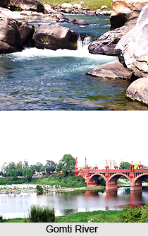
 The Gomti River starts off from the east of Pilibhit town at a height of 200 meters. The river is also known by the names as Gumti or Gomati. The Gomti River is a tributary of the Ganges River. The river drains the area between river Ramganga and Sharda. After flowing southwards through the districts of Lucknow, Barabhanki, Sultanpur, Faizabad and Jaunpur, it joins with the River Ganga.
Geography of Gomti River
The Gomti River originates from the Gomat Taal, otherwise called as Fulhaar Jheel which is found near the Madho Tanda in Pilibhit district in Uttar Pradesh, India. The river extends to about 900 km. The river appears to be a thin stream till it reaches Mohammadi Kheri, which is at a distance from 100 km, and is a small tehsil of the district of Lakhimpur Kheri, and small tributaries such as the Choha, Sukheta and Andhra Choha join Gomti River. From here onwards, it is joined by other small tributaries such as Kathina at mailani and Sarayan at a village in Sitapur district. The other major tributary is the Sai River. Then it reaches the Lucknow city and meanders through the city.
Major Cities of Gomti River
There are various cities that are situated on the banks of River Gomti such as Sultanpur, Lucknow, Jaunpur and Lakhimpur Kheri. These are the major cities that are prominent in the region, out of the total 15 cities in the catchment land. The river cuts the Jaunpur city into two equal half and becomes wider in Jaunpur. Gomti River has 22 tributaries and Sai River is considered as its major tributary.
Mythological Story of Gomti River
In Hindu Mythology, the river is considered as the daughter of Sage Vashistha. It is believed that bathing in the Gomti River would wash away ones sins. And as per the major religious work of Srimad Bhagavatam which is quite sacred, the Gomati is one of the many transcendental rivers in India.
Threats to Gomti River
According to the research conducted by CFSD, 2/3rd water of Gomti has depleted since 1950 and the aquatic animals have also been affected. If proper steps are not taken then the remaining water might dry up in the next 31 years. Besides aquatic animals, livelihood of around one lakh families depends on Gomti. Efforts are on to preserve the purity of this age old river.
Gomti River
The Gomti River originates from the east of Pilibhit town at a height of 200 meters.


