 Rising at an elevation of 914 m, the Indravati River rises in the Kalahandi district of Odisha on the western slopes of the Eastern Ghats. It is a River Godavari River">tributary of the Godavari River and is known to be the largest river in the Bastar district of the state of Chhattisgarh. The Indravati River flows for 535 km and has a drainage area of 41, 665 sq. km.
Myth behind origin of Indravati River
The formation of the Indravati River is based on an ancient Hindu mythological tale, involving Lord Indra and Indrani, who descended from the Heaven to stay in the forest of the fragranced Champa and Chandan trees. The 2 deities were deeply enthralled by the beauty of the place and wandered the forest blissfully. But things changed when Lord Indra went to the village of Sunabeda in the Nuapada district, where he met a beautiful maiden named Udanti and instantly fell in love.
Indra no longer wanted to return to Indrani and struck by the grief of separation she roamed the forest woefully. Eventually, Indrani came to know about Indra"s betrayal and enraged she turned herself as the Indravati River so that the two lovers suffer through the tides of separation. Even today, the two rivers of Indra and Udanti flow in the area but separately.
Course of Indravati River
With a catchment area of 7, 435 sq. km in Odisha, the Indravati River starts from the hills of Kalahandi and joins the Godavari River near the Bhadrakali village in the Bijapur district of the state of Chhattisgarh. The course of the river is well defined from its origin to its confluence with the Godavari River.
 Starting as a rivulet in Odisha, the Indravati River flows in a westerly direction through Bastar district of Chhattisgarh until it is deflected and runs north- west and then again takes a turn to the south- west. The Bastar district is one of the greenest and eco- friendly districts in India. The Indravati River at a variety of stages of its course is known to form the boundary between Chhattisgarh and Maharashtra.
The two main tributaries of the Godavari River, Indravati and Sabari are interconnected naturally in the Odisha area and the waters from the Indravati overflows into the Sabari through Jaura Nallah during floods.
Tributaries of Indravati River
The major right bank tributaries of the Indravati River are Bhaskel River, Narangi River, Nimbra River, Kotri River and Bandia River. The Nandiraj River is the only important left bank tributary of the Indravati River.
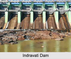
Indravati Dam
A total of 5 hydroelectric projects were planned but only one came through, the Indravati Dam or the Upper Indravati Hydro Power Project was built near the town of Mukhiguda in the Kalahandi district. It is one of the largest dams in India as well as Asia and produces 600 MW of electricity. The Upper Indravati Project envisages diversion of water, of the Indravati River in its upper reaches into the Mahanadi valley for power generation and irrigation.
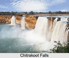
Ecology of Indravati River
The Indravati River forms the Chitrakoot Falls, which is located about 40 km from Jagdalpur in Chhattisgarh. Adjoining the region of Chhattisgarh, there is the Indravati National Park and Tiger Reserves.


