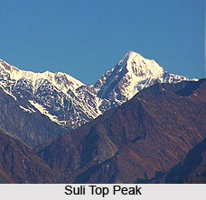
 Suli Top Peak is a Himalayan peak which is part of the Kumaon Division. It is situated over the eastern flank of the Kalabaland Glacier in the east of the Milam Valley. The Suli Top is situated at an altitude of 6,300 meters above mean sea level. The geographic coordinates of the mountain are 30 degree 24`00 North, 80 degree 19`12 East. The first climb to the summit was accomplished in the year 1986.
The other peaks on this geological formation are Chiring Ve at a height of 6,559 meters above mean sea level, Trigal at a height of 6,983 meters above mean sea level and Bamba Dhura at a height of 6,334 meters above mean sea level. This ridge is a divide between Lassar and Kalabaland valley.
This article is a stub. You can enrich by adding more information to it. Send your Write Up to content@indianetzone.com


