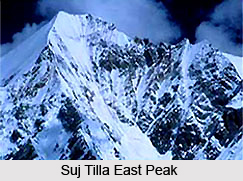
 Suitilla or Suj Tilla East Peak is a mountain peak in the Himalayas which is a part of the Kumaon division. Ralam Dhura Pass which connects Ralam valley to Darma valley is situated in the south of this peak. This peak has earned the sobriquet `peak of needles` because the peak is characterised by sharp ridges and cornices.
Location of Suj Tilla East Peak
It is located in the eastern part of Uttarakhand in the Pithoragarh district. It is situated above the junction of Kalabaland, Sankalp and Yankchar glaciers. Suj Tilla East is situated two hundred metres from Suj Tilla West. Perched at a height of 6,394 metres (20,978 feet) above mean sea level, Suj Tilla East Peak is twenty metres higher than Suj Tilla West. The geographic coordinates of the peak is 30 degree 19`48 North, 80 degree 22`48 East.
Connectivity of Suj Tilla East Peak
The most suitable route to the peak is through the south west face. It is situated 200 m away from Suj Tilla West. Suj Tilla East is 21 m higher than Suj Tilla West. This peak is yet to be climbed.
This article is a stub. You can enrich by adding more information to it. Send your Write Up to content@indianetzone.com


