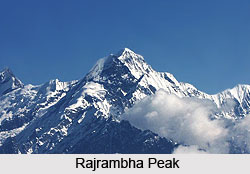
Rajrambha Peak , Uttarakhand - Informative & researched article on Rajrambha Peak , Uttarakhand
  Indianetzone: Largest Free Encyclopedia of India with thousand of articles Geography of India


in  
Art & Culture | Entertainment | Health | Reference | Sports | Society | Travel
Forum  | RSS Feeds  | Free E-magazine
Geography of India : Indian Climate l Indian Mountains l Indian Forests l Indian Soil l Indian Vegetation l Animal Husbandry in India l Resources in India l Indian Demography l Indian Industries l Indian Islands l Indian Airports l Zoos in India l Indian Mines & Minerals l Indian Physiography l Indian Transport l Indian Geology l Communication in India l Indian Trade l Indian Astronomers l Indian Telecommunications
Home > Reference > Geography of India > Indian Mountains > Mountain Peaks of India > Rajrambha Peak
Rajrambha Peak , Uttarakhand
The Rajrambha Mountain is a part of the Himalayan mountain ranges, which lie in the Kumaon region.

The Rajrambha peak is situated in the Pithoragarh district of Uttarakhand. It is a part of the Himalayan mountain ranges, which lie in the Kumaon region. The literal meaning of the term Rajrambha means ` celestial nymph` or Apsara in Hindi. This peak is situated I the south of the Kalabaland Glacier which is in the eastern Kumaun in the Ralam Valley. The peak is situated at an altitude of 6,537 metres above mean sea level.

The other peaks located in the vicinity which form the north south massif are Suitilla at an average elevation of 6,373 metres, Chaudhara at a height of 6,510 metres and Ngalaphu at a height of 6,410 metres above mean sea level. The Rajrambha peak forms a boundary between Lasser Yankti and Ralam Valley. It is easily accessible from Uttari Balati glacier passing the Balati plateau. Dhakar situated near Tawaghat in Pithoragarh district is the base camp from where one can climb the Rajrambha peak.

(Last Updated on : 21/01/2009)
  More on Mountain Peaks of India...
 
Anamudi Peak Arwa Group Avalanche Peak
Burphu Dhura Peak Changabang Peak Changuch Peak
Chembra Peak Chiring We Peak Dunagiri Peak
Guru Shikhar Peak Hardeol Peak Kamet Peak
Kodachadri Peak Nagalaphu Peak Nanda Pal Peak
Nilkantha Peak Om Parvat Peak Panchchuli Peaks
Phalut Peak Rajrambha Peak Rimo I Peaks
Saltoro Kangri Peak Suj Tilla East Peak Tadiandamol Peak
Teram Kangri Peaks Trisuli Peak Abi Gamin
Agastya Malai Mountain Balakun Bamba Dhura
Chaudhara Nanda Kot Nanda Devi
Rishi Pahar Kanchenjunga Peak Mount Mawma Peak
Suitilla Peak Siniolchu Peak Suli Top
Doddabetta Peak Chhiplakot Peak Sandakphu Peak
Swargarohini Anginda Peak K12 Peak
Kalsubai Peak Mount Abu Peak Nanda Devi East Peak
Nanda Gond Peak Nun Kun Peaks Sangthang Peak
Sispara Peak Trisul Peaks Badrinath Peak
Yamunotri Peak Moon Peak Kapilash Peak
Recently Updated Articles in Geography of India
  • Grand Trunk Road
    Grand Trunk Road is one of the oldest, longest and most important roads of South-Asia.
  •  
  • Types of Forests in India
    Elevation, topography, climate and soil type are the major factors which determine the type of forest.
  •  
  • Sispara Peak
    Sispara Peak is an Indian mountain peak, situated in the south Indian state of Tamil Nadu.
  •  
  • Indian Railway Zones
    Indian Railway network is classified into seventeen zones for administrative purposes.
  •  
E-mail this Article | Post a Comment
Free E-magazine
Subscribe to Free
E-Magazine on Geography of India

 
Rajrambha Peak , Uttarakhand - Informative & researched article on Rajrambha Peak , Uttarakhand
Sitemap
Contact Us   |   RSS Feeds
Copyright © 2008 Jupiter Infomedia Pvt. Ltd. All rights reserved including the right to reproduce the contents in whole or in part in any form or medium without the express written permission of Jupiter Infomedia Pvt. Ltd.