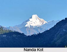
 Nanda Kot is a mountain peak nestled in the Uttarakhand state of India. It is situated at a height of 6,861 meters above mean sea level. On the basis of peakery data, it ranks as the 14th highest mountain in Uttarakhand and the 42nd highest mountain in India. Nanda Devi, Trisul, Changabang, Dunagiri, Hathi Parbat, and Rataban are the nearest peaks to Nanda Kot. This peak is well-known among the explorers and mountaineers.
Etymology of Nanda Kot
The literal meaning of the term Nanda Kot is `Nanda`s Fortress` which refers to the home of one of the sacred Hindu Goddess Parvati.
Location of Nanda Kot
It is located in the Pithoragarh district of Uttarakhand. It lies in the Kumaon Himalayan range outside the ring of peaks encircling the Nanda Devi Sanctuary. The Nanda Devi Sanctuary is in the southeast direction at a distance of fifteen kilometers from Nanda Devi.
Nanda Kot is connected to the Sanctuary wall through a high pass, which is known as the Pindari Kanda at a height of 5,269 meters. The Pindari Kanda, Nanda Kot and the ridge approaching south from the peak form a divide between the Pindar and the Ghori Ganga River valleys with Dana Dhura Pass connecting the two sides. There are several glaciers located in this region. The Kaphmi, Pindar, Lawan and the Shalang Glaciers drain the south, west, north and east sides of the peak respectively.
Climbing History of Nanda Kot
The first attempt to climb this peak was made in the year 1905 by explorer and mountaineer T.G. Longstaff. The peak was first successfully scaled in the year 1936 by a Japanese team led by Y. Hotta.
Presently, mountaineering expeditions to Nanda Kot generally follow the route through Loharkhet, Dhakuri Pass, Khati Village to Dwali base camp.
This article is a stub. You can enrich by adding more information to it. Send your Write Up to content@indianetzone.com


