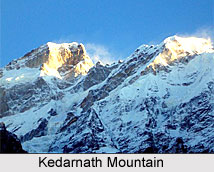
 Kedarnath Mountains are a group of two mountains in the Gangotri Group of peaks in the western Garhwal Himalayas namely Kedarnath peak or Kedarnath Main and Kedarnath Dome. Kedarnath is the highest peak on the south side of the Gangotri Glacier, and Kedarnath Dome is the third highest peak.
Location of Kedarnath Mountains
They are located in the northern Indian state of Uttarakhand, 15 kilometres (9 m) south of the Hindu holy site of Gaumukh, which is the source of the Bhagirathi River. Kedarnath peak lies on the main ridge that lies south to the Gangotri Glacier, and Kedarnath Dome is a sub-peak of the main peak, lying on a spur that is projecting towards the glacier, two kilometres northwest of Kedarnath.
First Ascent of Kedarnath Mountains
Both the peaks have relatively easy routes on their northwest sides, but the east face of Kedarnath Dome is a gigantic and very difficult rock climb. The Kedarnath Dome rises to an elevation of 6,831 m and is prominently viewed up to 100 m.
In the year 1947, both Kedarnath and Kedarnath Dome were first climbed together by a Swiss team led by André Roch. Their route on Kedarnath Dome, the northwest flank, is still considered as the standard route and is availed by most of the climbers. It is straightforward and relatively low-angle.The east face of Kedarnath Dome was first climbed in 1989 by a Hungarian expedition led by Attila Ozsvaith. Their climb involved sixty pitches of very rugged climbing.
Adventure at Kedarnath Mountains
Both the mountains are popular amongst the adventure enthusiasts. Its scenic beauty lures risk lovers from various places of the world. Kedarnath Dome is especially a popular ski ascent in the spring season. The adventure enthusiasts mainly follow the route on Kedarnath Dome, the northwest flank owing to its straightforwardness.
Nearby Attractions of Kedarnath Mountains
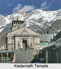
The nearby attraction of Kedarnath Mountains is Kedarnath town which is known for the Kedarnath Temple. It one of the holiest Hindu temples built in the honour of Lord Shiva. It is also one of the twelve Jyotirlingas, the holiest Hindu shrines of Shiva. The temple is nestled near the Mandakini River. It is said that the temple was built by Pandavas.


