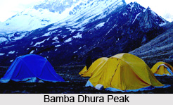
 Bamba Dhura is a mountain peak in the Himalayas situated in the Uttarakhand state of India. It is a part of the Kumaon division of the Himalayas. Bamba Dhura massif divides the Kalabaland and the Lassar Valley.
Location of Bamba Dhura Peak
Bamba Dhura is located in the Pithoragarh district of Uttarakhand. It is situated in the eastern part of the Pithorgarh district, which is in the left of the Milam Glacier. The peak is perched at a height of 6334 metres (20,781 feet) above mean sea level. Bamba Dhura is positioned on the northwest ridge at the end of the Kalabaland Glacier. The geographic coordinates of the peak are 30 degree 26 24 North, 80 degree 16 48 East.
Attractions of Bamba Dhura Peak
Bamba Dhura is surrounded by various beautiful peaks. `Kalabaland Dhura`, which is situated at an altitude of 6,105 metres above mean sea level is situated on the west of the peak and `Chiring We` situated at an altitude of 6,559 metres above mean sea level, is on the same massif.
The peak is remote and difficult to climb however it is well-known among the mountaineers and explorers. It was first climbed in the year 1977 from south by col between Bamba Dhura and Chiring We. Since then the peak is climbed through the south-eastern and western ridges between the two peaks.
This article is a stub. You can enrich by adding more information to it. Send your Write Up to content@indianetzone.com


